


Topic 53 of 92: Earth and Sun Digest
Wed, Aug 1, 2001 (01:50) |
Marcia (MarciaH)
This most excellent compilation comes out each Thursday. If Donald approves of this endeavor to include his publication, you will see it shortly. Otherwise this topic will be come a blank space in the index. Aloha Donald, and welcome to Geo!
85 responses total.
 Topic 53 of 92 [Geo]: Earth and Sun Digest
 Response 1 of 85: Marcia  (MarciaH) * Thu, Aug  2, 2001 (16:07) * 169 lines
Earth and Sun Digest for August 2, 2001
published free on Thursdays by Donald J. Boon
For those in fear of the End Times, a weekly look at the facts
".. a great earthquake, and a tenth of (Jerusalem) fell..." Revelation 11:13 (NRSV)
Week at a Glance
(All data are preliminary, details in tables below)
Earthquakes of 5 mag or greater thru Wed--18; quakes of 6M or greater: 6.5M Aegean Islands, 6.5 Alaska
California earthquakes in past week--477
(see http://groups.yahoo.com/group/World_Seismicity/message/429 )
Volcanic Ash over 5 mi (8 km)--Mexico, Ecuador, Italy
Sunspot No. High--115 on 26 July
Geomagnetic A-Index High--22 on 25 July, 23 on 31 July
Click-Date Maps (good to the day you click on them):
California map of 1.5M or greater in past week
at http://quake.usgs.gov/recenteqs/latest.htm
United States index map for regions
at http://earthquake.usgs.gov/activity/present.html
World map of 5M quakes for the past year
at http://www-seismo.hannover.bgr.de/ermos.html
Moon for August
4 full, 5 apogee, 12 last quarter, 19 new, 19 perigee, 25 first quarter
The apogee of the moon is on 5 August (252,444 miles far), while the perigee (221,927 miles near) is on 19 August.
The Perseid meteor shower peaks 12 and 13 August under the last quarter moon. Best viewing to see its spectacular fireballs is a
couple hours before dawn. The Kappa Cygnid shower with its slower meteors with yellowish tails peaks 17 August with the new
moon.
Dramatic color images from satellite of Kilauea's lava tubes are at:
http://earthobservatory.nasa.gov/Newsroom/NewImages/images. php3?img_id=5025
Recent Volcanic Ash Eruptions:
Ash data is summarized from the weekly GVN/USGS report
http://www.nmnh.si.edu/gvp/usgs/index.htm
Blue is mainland, Green is an island.
All ash elevations are in km above sea level.
Ash elevations of 5 mi/8 km are highlighted in red.
United States, Hawaii, KILAUEA, summit elev. 1222 m
small-to-moderate levels of lava entered the ocean
Montserrat, West Indies, SOUFRI�RE HILLS, summit elev. 1052 m
ash increased during 27 July through 29 July, to below 6 km;
see SPECIAL REPORT
Mexico, POPOCATEPETL, summit elev. 5426 m
Several small-to-moderate emissions of steam, gas, and small amounts of ash, on 24 July ash to 10.9 km
Ecuador, TUNGURAHUA, summit elev. 5023 m
Several small-to-moderate eruptions, ash on 25 July to 9 km
Japan, Ryukyu Islands:
KIKAI [SATSUMA-IWO-JIMA], summit elev. 717 m
ash fell during 19-21 July
SUWANOSE-JIMA, summit elev. 799 m
on 26 July ash to 1.3 km above the crater
Russia, Kamchatka,
BEZYMIANNY, summit elev. 2882 m
on 27 July an extrusive process at lava dome, on 23 and 24 July gas-and-steam to 3.6 km
SHIVELUCH, summit elevation 3283 m
Gas-and-steam plumes to 7 km
Philippines, Luzon, MAYON, summit elev. 2462 m
during 27-31 July occasional short-lived ash emissions
Italy, Sicily, ETNA, summit elev. 3315 m
eruptions continued, 31 July a cable car base station and a small tourist shop destroyed by lava, near-continuous ashfall south of
volcano, including town of Catania, highest cloud rising 8 km
EARTH
FIVE Index of Global earthquakes of 5.0 magnitude or greater
per U. S. Geological Survey:
(6.0 or greater are highlighted in red.), Others are
Japan Region, South Pacific,
DATE-(UTC)-TIME LAT LON DEP MAG Q COMMENTS
yy/mm/dd hh:mm:ss deg. deg. km
01/07/26 00:21:37 39.08N 24.33E 10.0 6.5M A AEGEAN SEA
01/07/26 00:34:56 38.94N 24.26E 10.0 5.0M A AEGEAN SEA
01/07/26 02:06:35 38.93N 24.31E 10.0 5.0M B AEGEAN SEA
01/07/26 02:09:48 38.92N 24.27E 10.0 5.0M A AEGEAN SEA
01/07/27 22:42:31 17.26S 72.51W 33.0 5.0M A NEAR COAST OF PERU
01/07/28 07:32:43 59.06N 155.12W 138.9 6.5M A SOUTHERN ALASKA
01/07/30 00:15:00 6.19S 152.95E 33.0 5.3M A NEW BRITAIN REGION, P.N.G.
01/07/30 04:34:43 4.07S 103.94W 10.0 5.2M A CENTRAL EAST PACIFIC RISE
01/07/30 19:50:09 3.30S 12.22W 10.0 5.2M A NORTH OF ASCENSION ISLAND
01/07/30 21:56:18 4.23S 102.10E 33.0 5.0M B SOUTHERN SUMATERA, INDONESIA
01/07/31 06:57:40 17.75S 178.81W 564.5 5.3M A FIJI ISLANDS REGION
01/07/31 09:43:14 5.28S 103.18E 33.0 5.5M A SOUTHERN SUMATERA, INDONESIA
01/07/31 12:24:04 51.18N 179.39E 33.0 5.3M A RAT ISLANDS, ALEUTIAN ISLANDS
01/07/31 15:08:04 15.12S 174.73W 33.0 5.0M B TONGA ISLANDS
01/07/31 15:11:18 1.57N 126.32E 33.0 5.8M A NORTHERN MOLUCCA SEA
01/07/31 22:22:22 26.90S 26.68E 10.0 5.1M B SOUTH AFRICA
01/08/01 03:00:16 34.92S 71.91W 33.0 5.0M B NEAR COAST OF CENTRAL CHILE
01/08/01 09:20:08 71.11N 12.88W 10.0 5.0M A JAN MAYEN ISLAND REGION
Note: A degree of latitude is about 69 miles. A degree of longitude falls to 0 mi at the poles.
United States Quakes 3.0 and greater:
01/07/26 05:26:44 35.94N 83.57W 5.0 3.2M A EASTERN TENNESSEE
01/07/26 15:56:46 53.54N 163.79W 33.0 4.8M A UNIMAK ISLAND REGION, ALASKA
01/07/28 01:09:28 36.05N 117.87W 2.7 3.7M CALIF-NEVADA BDR REG
01/07/28 07:32:43 59.06N 155.12W 138.9 6.5M A SOUTHERN ALASKA
01/07/29 19:50:23 56.67N 152.95W 33.0 4.5M A KODIAK ISLAND REGION, ALASKA
01/07/30 23:34:17 36.05N 117.88W 2.9 3.7M CALIF-NEVADA BDR REG
01/07/31 00:47:34 36.05N 117.88W 3.3 3.5M CALIF-NEVADA BDR REG
01/07/31 01:38:11 47.73N 117.45W 0.4 3.2M WASHINGTON
01/07/31 12:24:04 51.18N 179.39E 33.0 5.3M A RAT ISLANDS, ALEUTIAN ISLANDS
01/07/31 12:39:45 50.99N 179.33E 33.0 4.8M A RAT ISLANDS, ALEUTIAN ISLANDS
01/07/31 12:58:48 50.91N 179.42E 33.0 4.7M A RAT ISLANDS, ALEUTIAN ISLANDS
01/08/01 10:04:09 57.56N 155.30W 61.3 4.1M A ALASKA PENINSULA
01/08/01 16:19:37 49.39N 127.88W 10.0 4.4M A VANCOUVER ISL, CANADA REGION
SPECIAL REPORTS (3)
Montserrat's Rainy Eruption of 29 July
A torrential rainstorm in the West Indies blinded the eyes of the Montserrat Volcano Observatory during the eruption of Soufriere
Hills volcano, but the scars were too great to miss. They put it all together at
http://www.nmnh.si.edu/gvp/gvn/world/gvn00041.htm
The East Coast Fireball of 23 July
NASA has a special report on the widely seen fireball, entitled, "Meteorites Don't Pop Corn". Check it out by clicking on
http://science.msfc.nasa.gov/headlines/y2001/ast27jul_1.htm
Monthly Summary of Earthquakes of 6 or greater Magnitude
in the World, per United States Geological Survey Preliminary Global Report
YEAR: 93 94 95 96 97 98 99 00 01
June 1 11 12 12 3 3 3 22 10 with one 7M, one 8M
July 2 10 12 7 5 9 8 9 10 with one 7M
August 2 14 16 6 7 8 9 12, two 7M's
September 4 8 8 9 7 4 12 7
October 4 12 21 9 6 3 4 8
Yr total 19 110 160 109 76 63 103 109 (66)
Note: ( ) means the data is incomplete.
SUN
Sunspot numbers for the past week:
7/25 26 27 28 29 30 31 8/1
96 115 96 88 59 64 85 108
Planetary geomagnetic A Indices for same period:
22 14 9 5 8 9 23 12
"How long will the land mourn, and the grass of every field wither? For the wickedness of those who live in it the animals and the
birds are swept away, and because people said, '(God) is blind to our ways.'" Jeremiah 12:4
For additional references, click on
.. http://quake.usgs.gov/
Volcanic ash advisory reports and maps are available at:
.. http://www.ssd.noaa.gov/VAAC/washington.html
The Global Volcanism Network home page is at
.. http://www.nmnh.si.edu/gvp/gvn/notices.htm
Current events in our solar system are available at
.. http://www.spaceweather.com
Moon perigees and apogees are courtesy of
.. www.astronomy.com
Donald J. Boon, editor, pijskk24a@prodigy.net
 Topic 53 of 92 [Geo]: Earth and Sun Digest
 Response 2 of 85: Paul Terry Walhus (terry) * Thu, Aug  9, 2001 (16:58) * 1 lines
test
 Topic 53 of 92 [Geo]: Earth and Sun Digest
 Response 3 of 85: Marcia  (MarciaH) * Mon, Aug 13, 2001 (17:03) * 166 lines
Donald, I am afraid I would have to post your Earth and Sun Digest line by line with commands in,<> brackets to have it come out the way you send it to me, but it is still worthwhile having it. I had no trouble following the tables once I read the top line. Thanks! (I was not ignoring you, I simply could not post this till now.) Now I await the next one or go snitch it from world Seismology.
Earth and Sun Digest for August 9, 2001
published free on Thursdays by Donald J. Boon
For those in fear of the End Times, a weekly look at the facts
For those in fear of the End Times, a weekly look at the facts
focused with this observation on the "fives":
FIVE quakes of 5.x magnitude in FIVE Days
can cause a volcano to erupt ash FIVE miles
to the jet streams, where it can circle the globe in FIVE days.
Week at a Glance
(All data are preliminary, details in tables below)
Earthquakes of 5 mag or greater thru Wed--12; quakes of 6M or greater: 6.2 in Russia (Kamchatka), 6.5 in southern Pacific
Ocean
California earthquakes in past week--298
Volcanic Ash over 5 mi (8 km)--Montserrat (West Indies), Ecuador, Russia (Kamchatka)
Sunspot No. High--213 on 5 August
Geomagnetic A-Index High--23 on 5 August, 21 on 6 August
Click-Date Maps (good to the day you click on them):
California map of 1.5M or greater in past week
at http://quake.usgs.gov/recenteqs/latest.htm
United States index map for regions
at http://earthquake.usgs.gov/activity/present.html
World map of 5M quakes for the past year
at http://www-seismo.hannover.bgr.de/ermos.html
Moon for August
4 full, 5 apogee, 12 last quarter, 19 new, 19 perigee, 25 first quarter
The perigee of the moon (221,927 miles near) is on 19 August.
The Perseid meteor shower peaks 12 and 13 August under the last quarter moon Best viewing to see its spectacular fireballs
is a couple hours before dawn. The Kappa Cygnid shower with its slower meteors with yellowish tails peaks 17 August with
the New Moon.
According to Earthweek, Damascus, Syria, a city of over two million population, can deliver running water to its citizens
only four hours a day because ancient sources have dried up.
Recent Volcanic Ash Eruptions:
Ash data is summarized from the weekly GVN/USGS report
http://www.nmnh.si.edu/gvp/usgs/index.htm
Blue is mainland, Green is an island.
All ash elevations are in km above sea level.
Ash elevations of 5 mi/8 km are highlighted in red.
United States, Hawaii, KILAUEA, summit elev. 1222 m
moderate amounts of lava flow into the sea
Montserrat, West Indies, SOUFRI�RE HILLS, summit elev. 1052 m
on 4 August ash up in two different directions, to 4.6 km and NW; to 9.7 km and NE
Mexico, POPOCATEPETL, summit elev. 5426 m
several small emissions of steam, gas, and small amounts of ash
Ecuador, TUNGURAHUA, summit elev. 5023 m
during 2-3 August continuous ash emission, large ash eruptions on 5 August to 12.5 km and 8 August to 8 km
Russia, Kamchatka,
BEZYMIANNY, summit elev. 2882 m
on 7 August ash 10 km
SHIVELUCH, summit elevation 3283 m
on the night of 1 August ash fell 46 km from the volcano.
Philippines, Luzon, MAYON, summit elev. 2462 m
during 1-4 August ejection of lava fragments to 100 m above the rim.
Italy, Sicily, ETNA, summit elev. 3315 m
around 1 August to 5.5 km, during 2-5 August international airport in Catania closed for the fourth time due to ash
EARTH
FIVE Index of Global earthquakes of 5.0 magnitude or greater
per U. S. Geological Survey:
(6.0 or greater are highlighted in red.), Others are Japan Region, South Pacific.
DATE-(UTC)-TIME LAT LON DEP MAG Q COMMENTS
yy/mm/dd hh:mm:ss deg. deg. km
01/08/02 08:45:25 9.17S 122.06E 33.0 5.0M B SAVU SEA
01/08/02 23:41:07 56.37N 163.64E 26.9 6.2M A NEAR EAST COAST OF KAMCHATKA
01/08/04 01:44:53 2.83N 126.95E 33.0 5.8M A NORTHERN MOLUCCA SEA
01/08/04 18:55:08 15.85N 147.43E 33.0 5.2M A MARIANA ISLANDS REGION
01/08/05 05:16:16 12.24N 93.37E 96.0 5.6M A ANDAMAN ISLANDS, INDIA REGION
01/08/05 11:58:05 10.95S 165.03E 33.0 5.1M B SANTA CRUZ ISLANDS
01/08/06 03:52:59 55.59S 123.16W 10.0 6.5M A SOUTHERN EAST PACIFIC RISE
01/08/06 04:53:13 47.23N 142.81E 10.0 5.0M A SAKHALIN ISLAND, RUSSIA
01/08/06 07:55:24 2.13N 128.50E 233.9 5.1M A HALMAHERA, INDONESIA
01/08/06 17:08:45 8.48S 74.84W 137.3 5.5M A PERU-BRAZIL BORDER REGION
01/08/07 03:22:34 8.61S 113.81E 75.8 5.7M A JAWA, INDONESIA
01/08/08 13:08:03 10.86S 165.41E 33.0 5.4M A SANTA CRUZ ISLANDS
01/08/09 02:06:59 14.36S 72.63W 33.0 5.5M A CENTRAL PERU
01/08/09 03:33:44 18.07S 69.21W 112.7 5.5M A NORTHERN CHILE
01/08/09 13:08:36 51.45N 178.09W 33.0 5.2M A ANDREANOF ISL, ALEUTIAN IS.
01/08/09 13:20:17 7.33S 120.72E 33.0 5.2M A FLORES SEA
Note: A degree of latitude is about 69 miles. A degree of longitude falls to 0 miles at the North and South poles.
United States Quakes 3.0 and greater:
01/08/01 16:19:37 49.39N 127.88W 10.0 4.4M A VANCOUVER ISL, CANADA REGION
01/08/02 16:21:18 37.22N 117.79W 10.1 3.7M CALIF-NEVADA BDR REG
01/08/04 01:13:25 34.29N 93.21W 5.0 3.2M D ARKANSAS
01/08/04 19:05:55 35.73N 118.47W 4.5 3.2M CENTRAL CALIFORNIA
01/08/05 10:13:44 44.27N 129.28W 10.0 4.6M A OFF COAST OF OREGON
01/08/05 11:11:44 50.53N 129.72W 10.0 4.5M A VANCOUVER ISL, CANADA REGION
01/08/06 21:40:50 50.28N 178.88W 33.0 4.3M C ANDREANOF ISL, ALEUTIAN IS.
01/08/07 16:52:54 32.11N 116.42W 7.0 3.5M CALIF.-BAJA CALIF. BDR
01/08/09 13:08:36 51.45N 178.09W 33.0 5.2M A ANDREANOF ISL, ALEUTIAN IS.
SPECIAL REPORTS (2)
The Ash of Tungurahua
The Earth and Sun Digest has documented the weekly high eruptions of Mount Tungurahua in Ecuador since at least April.
What happens to this ash? The Global Volcanism Program from the Smithsonian archives answers such questions in a
program no longer funded, called "Ask a Volcanologist". Here is the answer to "How high can explosive eruptions go and
how far can the ash be spread?", with pictures and a comment on the effect of ash on global cooling:
http://volcano.und.nodak.edu/vwdocs/frequent_que stions/top_101/Eruption/Eruption6.html
The archive is at: http://volcano.und.nodak.edu/vwdocs/frequent_questions/top _101/Eruption.html
This report from Tuesday is an example of the distribution of ash after an eruption of Tungurahua to 26,000 feet:
http://www.nmnh.si.edu/gvp/gvn/aviation/sab00110.htm
The prevailing winds at the Equator are westerly, so ash from Ecuador and Indonesia goes west over the El Nino eastern
Pacific area, and can affect India, eastern Africa and the Middle East.
Monthly Summary of Earthquakes of 6 or greater Magnitude
in the World, per United States Geological Survey Preliminary Global Report
YEAR: 93 94 95 96 97 98 99 00 01
June 1 11 12 12 3 3 3 22 10 with one 7M, one 8M
July 2 10 12 7 5 9 8 9 10 with one 7M
August 2 14 16 6 7 8 9 12 (2)
September 4 8 8 9 7 4 12 7
October 4 12 21 9 6 3 4 8
Yr total 19 110 160 109 76 63 103 109 (67)
Note: ( ) means the data is incomplete.
SUN
Sunspot numbers for the past week:
8/1 2 3 4 5 6 7 8
108 113 140 182 214 182 177 191
Planetary geomagnetic A Indices for same period:
12 8 14 9 23 21 13 9
".. a great earthquake, and a tenth of (Jerusalem) fell..." Revelation 11:13 (NRSV)
"How long will the land mourn, and the grass of every field wither? For the wickedness of those who live in it the animals
and the birds are swept away, and because people said, '(God) is blind to our ways.'" Jeremiah 12:4
For additional references, click on
.. http://quake.usgs.gov/
Volcanic ash advisory reports and maps are available at:
.. http://www.ssd.noaa.gov/VAAC/washington.html
The Global Volcanism Network home page is at
.. http://www.nmnh.si.edu/gvp/gvn/notices.htm
Current events in our solar system are available at
.. http://www.spaceweather.com
Moon perigees and apogees are courtesy of
.. www.astronomy.com
Donald J. Boon, editor, pijskk24a@prodigy.net
 Topic 53 of 92 [Geo]: Earth and Sun Digest
 Response 4 of 85: Marcia  (MarciaH) * Mon, Aug 13, 2001 (17:05) * 1 lines
(At least I got the introduction centered. Next time I will work on colors...) Thanks, Donald, for your hard work. To see how truly spectacular this work of his is, see it in all its glory at http://groups.yahoo.com/group/World_Volcanism/
 Topic 53 of 92 [Geo]: Earth and Sun Digest
 Response 5 of 85: Marcia  (MarciaH) * Thu, Aug 16, 2001 (13:39) * 72 lines
I will post Dobald Boon's Earth and Sund Digest in the .txt form he sent as an alternative. It contains no tables. If anyone misses them, and can figure them out with the alignments being as they are, I will repost them as intact as I possibly can. Let me know!
Earth and Sun Digest for August 16, 2001
published free on Thursdays by Donald J. Boon
For those in fear of the End Times, a weekly look at the facts
focused with this observation on the "fives":
FIVE quakes of 5.x magnitude in FIVE Days
can cause a volcano to erupt ash FIVE miles
to the jet streams, where it can circle the globe in FIVE days.
Week at a Glance
(All data are preliminary, details in tables in full edition)
Earthquakes of 5 mag or greater thru Wed--19; quakes of 6M or greater: 6.4,
Japan
California earthquakes in past week--278
Volcanic Ash over 5 mi (8 km)--Ecuador
Sunspot No. High--196 on 12 August
Geomagnetic A-Index High--19 on 13 August
Click-Date Maps (good to the day you click on them):
California map of 1.5M or greater in past week
at http://quake.usgs.gov/recenteqs/latest.htm
United States index map for regions
at http://earthquake.usgs.gov/activity/present.html
World map of 5M quakes for the past year
at http://www-seismo.hannover.bgr.de/ermos.html
Moon for August
4 full, 5 apogee, 12 last quarter, 19 new, 19 perigee, 25 first quarter
The perigee of the moon (221,927 miles near) is on 19 August.
Today on www.SpaceWeather.com is this report:
"RADIATION STORM: The flux of high-energy protons around our planet soared
to 1000 times normal at ~0300 UT on August 16th. The ongoing S2-class solar
radiation storm is unusual because it was not triggered by a major flare on
the Earth-facing side of the Sun. Instead, it appears to be the result of a
backside explosion detected by SOHO coronagraphs on August 15th."
The Kappa Cygnid meteor shower has slower meteors with yellowish tails than
the Perseid. It peaks 17 August. The New Moon helps visibility. See
www.spaceweather.com
Recent Volcanic Ash Eruptions:
Ash data is summarized from the weekly GVN/USGS report
http://www.nmnh.si.edu/gvp/usgs/index.htm
All ash elevations are in km above sea level. (a.s.l.)
United States, Hawaii, KILAUEA, summit elev. 1222 m
lava continued to enter the ocean
Mexico, POPOCATEPETL, summit elev. 5426 m
small emissions of steam, gas, and small amounts of ash increased, on 9
August an ash cloud rose to 7.6 km
Ecuador, TUNGURAHUA, summit elev. 5023 m
since at least 6 August steam-and-ash clouds to 7.5-11.6 km, on 13 August
ash to 11.6 km and to 10 km
Russia, Kamchatka,
BEZYMIANNY, summit elev. 2882 m
on 7 August ash clouds to 4.9 km
SHIVELUCH, summit elevation 3283 m
Small gas-and-steam plumes rose to 3.5 m
Note 1: There is a map in the El Nino project from NOAA that appears to show
also the effect of volcanic ash distribution. See
http://psbsgi1.nesdis.noaa.gov:8080/PSB/EPS/SST/climo.html
Note 2: The last Indonesian report available was to July 15.
The full, color-coded Earth and Sun Digest can be found at
http://groups.yahoo.com/group/World_Volcanism/messages
 Topic 53 of 92 [Geo]: Earth and Sun Digest
 Response 6 of 85: Marcia  (MarciaH) * Thu, Aug 23, 2001 (14:36) * 45 lines
Earth and Sun Digest for August 23, 2001
published free on Thursdays by Donald J. Boon
For those in fear of the End Times, a weekly look at the facts
Week at a Glance
(All data are preliminary, details in tables below)
Earthquakes of 5 mag or greater thru Wed--7; quakes of 6M or greater: 7.0M
in New Zealand
California earthquakes in past week--243
Volcanic Ash over 5 mi (8 km)--Ecuador
Sunspot No. High--183 on 22 August
Geomagnetic A-Index High--29 on 17 August
Click-Date Maps (good to the day you click on them):
California map of 1.5M or greater in past week
at http://quake.usgs.gov/recenteqs/latest.htm
United States index map for regions
at http://earthquake.usgs.gov/activity/present.html
World map of 5M quakes for the past year
at http://www-seismo.hannover.bgr.de/ermos.html
Moon for August
4 full, 5 apogee, 12 last quarter, 19 new, 19 perigee, 25 first quarter
The apogee of the moon (252,482 miles far) is on 1 September, the following
perigee (222,531 miles near) is 16 September.
The major event of the week is a 7.0 magnitude earthquake northeast of New
Zealand, which to date has had 130 aftershocks in the 3 to 5 magnitude
range. The only transglobal quake reported to date is in Kazakhstan, but
quakes in the United States have followed big quakes in New Zealand within
ten days from Hawaii and Alaska to California and Maine. See SPECIAL REPORT
in full report at: http://groups.yahoo.com/group/World_Volcanism/messages
Recent Volcanic Ash Eruptions:
The weekly GVP-USGS Weekly Report is not available at press time.
All ash elevations are in km above sea level. (a.s.l.)
from
http://www.epn.edu.ec/~igeo/Vulcanologia/Volcanes/Tungurahua/Informet/inform
et.html, per Smithsonian's Volcano Listserv:
Ecuador, TUNGURAHUA, summit elev. 5023 m
ash to 8 km on 19 August
 Topic 53 of 92 [Geo]: Earth and Sun Digest
 Response 7 of 85: Marcia  (MarciaH) * Thu, Aug 23, 2001 (14:38) * 2 lines
As always, The full, color-coded Earth and Sun Digest can be found at
http://groups.yahoo.com/group/World_Volcanism/messages
 Topic 53 of 92 [Geo]: Earth and Sun Digest
 Response 8 of 85: Marcia  (MarciaH) * Thu, Aug 30, 2001 (17:21) * 81 lines
Earth and Sun Digest for August 30, 2001
published free on Thursdays by Donald J. Boon
Week at a Glance
(All data are preliminary, details in tables in full edition)
Earthquakes of 5 mag or greater thru Wed--19; four quakes of 6M or greater:
6.1M BISMARCK SEA (Papua-New Guinea, 6.0M PANAMA, 6.0M NORTHERN MOLUCCA SEA,
Indonesia, 6.0M NORTHERN CHILE
California earthquakes in past week--223
Volcanic Ash over 5 mi (8 km)--none
Sunspot No. High--194 on 23 August
Geomagnetic A-Index High--17 on 22 August
Click-Date Maps (good to the day you click on them):
California map of 1.5M or greater in past week
at http://quake.usgs.gov/recenteqs/latest.htm
United States index map for regions
at http://earthquake.usgs.gov/activity/present.html
World map of 5M quakes for the past year
at http://www-seismo.hannover.bgr.de/ermos.htm l
Moon for September
1 apogee, 2 full, 10 last quarter, 16 perigee, 17 new, 24 first quarter, 30
another apogee
The apogee of the moon (252,482 miles far) is on 1 September, the following
perigee (222,531 miles near) is 16 September.
The sunspot which unleashed a powerful X5-category solar flare recently has
passed center but can bring more eruptions. A new pair of sunspots yet to
cross center also pose a substantial threat for strong flares. See
www.spaceweather.com
The 7.0 magnitude earthquake northeast of New Zealand on 21 August has
spawned large aftershocks in the past ten days, with the 6M quakes listed in
Week at a Glance. A study of the aftershocks 5M or greater in 1999 following
a series of 6M quakes also north of New Zealand is in Special Reports in
this issue.
On September 12 in Alaska at 3:18 AM local time the moon will eclipse the
planet Jupiter.
Newly discovered Comet Petriew can be seen at
http://science.nasa.gov/headlines/y2001/ast24aug_1.htm
and followed through www.spaceweather.com
It was spotted by an amateur astronomer with a telescope at a star party.
Recent Volcanic Ash Eruptions:
Ash data is summarized from the weekly GVN/USGS report
http://www.nmnh.si.edu/gvp/usgs/index.htm
All ash elevations are in km above sea level. (a.s.l.)
KILAUEA Hawaii, USA, summit elev. 1222 m
lava continued to flow into the ocean
POPOCAT�PETL M�xico, summit elev. 5426 m
small emissions of steam, gas, and minor amounts of ash.
SOUFRI�RE HILLS Montserrat, West Indies, summit elev. 1052 m
ash emission on 26 August to 2 km
TUNGURAHUA Ecuador, summit elev. 5023 m
nearly continuous ash emissions since 6 August, on 24 August ash cloud to
7.6 km.
VILLARRICA central Chile, summit elev. 2847 m
on 9, 16, 17, and 21 August volcanic ballistic clasts fell near crater the
crater.
SHIVELUCH Kamchatka Peninsula, Russia, summit elev. 3283 m
several small gas-and-steam plumes to a maximum of 5.3 km, pyroclastic flows
on 23 August.
KARANGETANG [Api Siau] Siau Island, Indonesia, summit elev. 1784 m
during 30 July-12 August a steam-and-ash plume rose 2.4 km
KERINCI Sumatra, Indonesia, summit elev. 3805 m
on 9 August an ash cloud to 4.5 km
LOKON-EMPUNG northern Sulawesi, Indonesia, summit elev. 1580 m
during 30 July-12 August small ash plumes to 1.9 km
MAKIAN Halmahera, Indonesia, summit elev. 1357 m
reported volcanic activity on 16 August was only a bush fire
MERAPI central Java, Indonesia, summit elev. 2947 m
During 30 July-12 August lava avalanches
Full version of Digest is at:
http://groups.yahoo.com/group/World_Volcanism/ and
http://groups.yahoo.com/group/World_Seismicity/
 Topic 53 of 92 [Geo]: Earth and Sun Digest
 Response 9 of 85: Marcia  (MarciaH) * Wed, Sep  5, 2001 (00:47) * 56 lines
From Donald Boon, our Geo-wizard:
All,
Family matters cause me to post the Earth and Sun Digest early this week.
It will be caught up later. The full Digest can be found at
http://groups.yahoo.com/group/World_Volcanism/messages
Here are the leaders:
Week at a Glance
(All data are preliminary, details in tables below)
Earthquakes of 5 mag or greater thru Tuesday--11; two quakes of 6M or
greater: 6.1M NORTH INDIAN OCEAN, 6.3M PACIFIC-ANTARCTIC RIDGE
California earthquakes in past week--254 (Tuesday)
Volcanic Ash over 5 mi (8 km)--none
Sunspot No. High--168 on 3 and 4 September
Geomagnetic A-Index High--20 on 4 September
Click-Date Maps (good to the day you click on them):
California map of 1.5M or greater in past week
at http://quake.usgs.gov/recenteqs/latest.htm
United States index map for regions
at http://earthquake.usgs.gov/activity/present.html
World map of 5M quakes for the past year
at http://www-seismo.hannover.bgr.de/ermos.html
Moon for September
1 apogee, 2 full, 10 last quarter, 16 perigee, 17 new, 24 first quarter, 30
another apogee
The apogee of the moon (252,482 miles far) is on 1 September, the following
perigee (222,531 miles near) is 16 September.
The Jewish New Year, Rosh HaShanah, is 18 September.
On September 12 in Alaska at 3:18 AM local time the moon will eclipse the
planet Jupiter.
Newly discovered Comet Petriew can be seen at
http://science.nasa.gov/headlines/y2001/ast24aug_1.htm
and followed through www.spaceweather.com
Recent Volcanic Ash Eruptions:
Ash data is summarized from VAAC and KVERT reports.
All ash elevations are in km above sea level. (a.s.l.)
TUNGURAHUA, Ecuador, summit elev. 5023 m
ash to 5.8 on 3 September
SHEVELUCH VOLCANO, Russia, Kamchatka, summit elev. 2447 m
on August 30 and 31 possible short-lived ash explosions to 5.5 km
Stay safe! Donald
 Topic 53 of 92 [Geo]: Earth and Sun Digest
 Response 10 of 85: Marcia  (MarciaH) * Mon, Sep 10, 2001 (23:09) * 59 lines
Again, my thanks to Donald Boon for supplying this excellent compendium. Please go to the bottom link to see the Digest in its entirety.
Because of vacation but still two 6M quakes, an incomplete early report was
posted. This is the final report for Sept. 6. The complete report is
posted on
http://groups.yahoo.com/group/World_Volcanism/messages
Week at a Glance
(All data are preliminary.)
Earthquakes of 5 mag or greater thru Tuesday--14; two quakes of 6M or
greater: 6.1M NORTH INDIAN OCEAN, 6.3M PACIFIC-ANTARCTIC RIDGE
California earthquakes in past week--254 (Tuesday)
Volcanic Ash over 5 mi (8 km)--none
Sunspot No. High--175 on 5 September
Geomagnetic A-Index High--20 on 4 September
Click-Date Maps (good to the day you click on them):
California map of 1.5M or greater in past week
at http://quake.usgs.gov/recenteqs/latest.htm
United States index map for regions
at http://earthquake.usgs.gov/activity/present.html
World map of 5M quakes for the past year
at http://www-seismo.hannover.bgr.de/ermos.html
Moon for September
1 apogee, 2 full, 10 last quarter, 16 perigee, 17 new, 24 first quarter, 30
another apogee
The apogee of the moon (252,482 miles far) is on 1 September, the following
perigee (222,531 miles near) is 16 September.
The Jewish New Year, Rosh HaShanah, is 18 September.
On September 12 in Alaska at 3:18 AM local time the moon will eclipse the
planet Jupiter.
Newly discovered Comet Petriew can be seen at
http://science.nasa.gov/headlines/y2001/ast24aug_1.htm
and followed through www.spaceweather.com
Recent Volcanic Ash Eruptions:
Ash data is summarized from VAAC and KVERT reports.
All ash elevations are in km above sea level. (a.s.l.)
KILAUEA Hawaii, USA, summit elev. 1,22 m
lava continued to enter the sea
POPOCAT�PETL M�xico, summit elev. 5426 m
small emissions of steam, gas, and minor amounts of ash
SOUFRI�RE HILLS Montserrat, West Indies, summit elev. 1052 m
new lava dome in the scar produced by the 29 July collapse. small
pyroclastic flows
TUNGURAHUA Ecuador, summit elev. 5023 m
Small amounts of ash, highest ash cloud on 3 September to 5.8 km
SHIVELUCH Kamchatka Peninsula, Russia, summit elev. 3283 m
during 24-31 August short-lived explosions, on 30 and 31 to 5.5 km
LOKON-EMPUNG northern Sulawesi, Indonesia, summit elev. 1580 m
on 18 August an ash cloud that rose 800 m above the crater
RABAUL New Britain Island, Papua New Guinea, summit elev. 688 m
on 28 August very mild ash eruptions began, and continued to 31 August
 Topic 53 of 92 [Geo]: Earth and Sun Digest
 Response 11 of 85: Marcia  (MarciaH) * Thu, Sep 13, 2001 (15:16) * 72 lines
Thanks again Donald!
All, here is the abridged version of the digest. The full version can be
viewed at
http://groups.yahoo.com/group/World_Volcanism/message/201
Earth and Sun Digest for September 13, 2001
by Donald J. Boon,
remembering the victims of September 11
"The dome (of the Dome of the Rock in Jerusalem) fell in an earthquake and
was rebuilt in 1022." The infamous Hakim, the sixth Egyptian Caliph,
996-1021, destroyed the Holy Sepulchre (the Anastasis) in 1010 A.D. The news
of the destruction brought back by pilgrims was one of the causes of the
first Crusade.
from the online New Advent Catholic Encyclopedia.
Week at a Glance
(All data are preliminary)
Earthquakes of 5 mag or greater thru Wednesday--10; two quakes of 6M or
greater: 6.4M IRIAN JAYA REGION, INDONESIA, 6.4M FIJI ISLANDS REGION
California earthquakes in past week--241
Volcanic Ash over 5 mi (8 km)--TUNGURAHUA Ecuador
Sunspot No. High--291 on 9 September
Geomagnetic A-Index High--113 on 12 September
Click-Date Maps (good to the day you click on them):
California map of 1.5M or greater in past week
at http://quake.usgs.gov/recenteqs/latest.htm
United States index map for regions
at http://earthquake.usgs.gov/activity/present.html
World map of 5M quakes for the past year
at http://www-seismo.hannover.bgr.de/ermos.html
Moon for September
1 apogee, 2 full, 10 last quarter, 16 perigee, 17 new, 24 first quarter, 30
another apogee
The perigee (222,531 miles near) is 16 September.
Several bright coronal mass ejections (CMEs) billowed away from the Sun
during the past 24 hours. Most were not Earth-directed. Earth's
magnetosphere could experience glancing or even direct blows on Sept. 13th
or 14th. See www.spaceweather.com
The Jewish New Year, Rosh HaShanah, is 18 September.
Recent Volcanic Ash Eruptions:
Ash data is summarized from the weekly GVN/USGS report
http://www.nmnh.si.edu/gvp/usgs/index.htm[/url
All ash elevations are in km above sea level.
LOIHI SEAMOUNT Hawaii, USA, summit elev. -980 m
on 10 September earthquake swarm began
KILAUEA Hawaii, USA, summit elev. 1,222 m
lava continued to flow into the ocean
POPOCAT�PETL M�xico, summit elev. 5,426 m
on 9 September steam-and-ash emissions to 6.4 km
SHIVELUCH Kamchatka Peninsula, Russia, summit elev. 3,283 m
on 4 September an ash plume to 4.3 km
SOUFRI�RE HILLS Montserrat, West Indies, summit elev. 1,052 m
ash venting at irregular intervals, ash clouds not above 1.5 km
TUNGURAHUA Ecuador, summit elev. 5,023 m
several small-to-moderate eruptions, highest ash cloud on
8 September to 10.5 km
Note: There is a map in the El Nino project from NOAA that appears to show
also the effect of volcanic ash distribution. See
http://psbsgi1.nesdis.noaa.gov:8080/PSB/EPS/SST/climo.html
 Topic 53 of 92 [Geo]: Earth and Sun Digest
 Response 12 of 85: Marcia  (MarciaH) * Thu, Sep 20, 2001 (18:15) * 75 lines
From the estimable Donald Boon:
Here is the abbreviated Digest. The complete edition is available at
World_Volcanism, World_Seismicity, the Prodigy News Community's
Science/Environment BB, and at www.bbmessages.com on its Planet Earth BB.
Earth and Sun Digest for September 20, 2001
published free by Donald J. Boon on Thursdays
remembering the victims of September 11
by quantifying natural phenomena
Historical notes on Jerusalem and its Muslim Dome of the Rock:
"The dome fell in an earthquake and was rebuilt in 1022." The infamous
Hakim, the sixth Egyptian Caliph, 996-1021, destroyed the Holy Sepulchre
(the Anastasis) in 1010 A.D. The news of the destruction brought back by
pilgrims was one of the causes of the first Crusade.
from the online New Advent Catholic Encyclopedia.
Week at a Glance
(All data are preliminary, details in tables elsewhere)
Earthquakes of 5 mag or greater thru Wednesday--21; three quakes of 6M or
greater: 6.0M VANCOUVER ISL, CANADA, 6.0M TONGA ISLANDS REGION, 6.0M BANDA
SEA
California earthquakes in past week--195
Volcanic Ash over 5 mi (8 km)--Ecuador
Sunspot No. High--228 on 12 September
Geomagnetic A-Index High--18 on 13 September
Click-Date Maps (good to the day you click on them):
California-Nevada map of 1.5M or greater in past week
at http://quake.usgs.gov/recenteqs/latest.htm
United States index map for regions
at http://earthquake.usgs.gov/activity/present.html
World map of 5M quakes for the past year
at http://www-seismo.hannover.bgr.de/ermos.html
Middle East map with recent quakes
at http://neic.usgs.gov/neis/current/m_east.html
Moon for September
1 apogee, 2 full, 10 last quarter, 16 perigee, 17 new, 24 first quarter, 30
apogee
The second apogee of the moon (252,144 miles far) in September is the 30th..
Coronal mass ejections (CMEs) from the Sun continue. Most were not
Earth-directed. See www.spaceweather.com
NASA's Deep Space 1 (DS1) probe will plunge into the turbulent coma of
periodic comet Borrelly on Sept. 22nd. Deep Space 1 is too small to see from
Earth. However, amateur astronomers with 10" or larger telescopes can view
the 10th magnitude comet in the morning sky near the bright twin stars of
the constellation Gemini. More at www.spaceweather.com
Recent Volcanic Ash Eruptions:
Ash data is summarized from the weekly GVN/USGS report
http://www.nmnh.si.edu/gvp/usgs/index.htm
All ash elevations are in km above sea level. (a.s.l.)
ETNA Sicily, Italy, summit elev. 3,315 m
dense gas clouds
KARANGETANG [Api Siau] Siau Island, Indonesia, summit elev. 1,784 m
on 9 September a pyroclastic flow
KERINCI Sumatra, Indonesia, summit elev. 3,805 m
on 9 September ash plumes to 4.3 km
KILAUEA Hawaii, USA, summit elev. 1,222 m
lava continued to flow into the ocean, during 12 and 13 September very
slight deflation
POPOCAT�PETL M�xico, summit elev. 5,426 m
small emissions of steam, gas, and minor amounts of ash
SHIVELUCH Kamchatka Peninsula, Russia, summit elev. 3,283 m
During 7-14 September several gas-and-ash plumes, the highest 4.5 km, on 12
September ash plume to 4.3 km
SOUFRI�RE HILLS Montserrat, West Indies, summit elev. 1,052 m
ash venting at irregular intervals slightly above the summit
TUNGURAHUA Ecuador, summit elev. 5,023 m
during the week near-summit ash-and-gas emissions, highest ash cloud reached 8 km
 Topic 53 of 92 [Geo]: Earth and Sun Digest
 Response 13 of 85: Marcia  (MarciaH) * Tue, Oct  2, 2001 (02:12) * 67 lines
Earth and Sun Digest for September 27, 2001
Full Edition at http://groups.yahoo.com/group/World_Volcanism/message/222
by Donald J. Boon on Thursdays
remembering the victims of September 11
An historical quake in Jerusalem ca 30 A.D.:
"Jesus, when he had cried again with a loud voice, yielded up the ghost.
And, behold, the veil of the temple was rent in twain from the top to the
bottom;
and the earth did quake, and the rocks rent; And the graves were opened;
and many bodies of the saints which slept arose," Matthew 27:50-52 KJV
Week at a Glance
(All data are preliminary)
Earthquakes of 5 mag or greater thru Wednesday--14; quake of 6M or greater:
6.0M COLOMBIA
California earthquakes in past week--227
Volcanic Ash over 5 mi (8 km)--Ecuador
Sunspot No. High--315, 320 on 24, 25 September
Geomagnetic A-Index High--27 on 23 September
Click-Date Maps (good to the day you click on them):
California-Nevada map of 1.5M or greater in past week
at http://quake.usgs.gov/recenteqs/latest.htm
United States index map for regions
at http://earthquake.usgs.gov/activity/present.html
World map of 5M quakes for the past year
at http://www-seismo.hannover.bgr.de/ermos.html
Middle East map with recent quakes
at http://neic.usgs.gov/neis/current/m_east.html
Moon for October
2 full, 10 last quarter, 14 perigee, 16 new, 24 first quarter, 26 apogee
The apogee of the moon (252,144 miles far) is 30 September. The next perigee
is 14 October (224,717 miles)
Coronal mass ejections (CMEs) from the Sun continue, with one X Class flare
that blocks radio transmissions. See www.spaceweather.com
Recent Volcanic Ash Eruptions:
Ash data is summarized from the weekly GVN/USGS report
http://www.nmnh.si.edu/gvp/usgs/index.htm
All ash elevations are in km above sea level. (a.s.l.)
IWO-JIMA Volcano Islands, Japan; summit elev. 161 m; on 21 September
seawater rose several ten's of meters above sea level with steam to 100-300
m at two points 50 m apart and 150-200 m from the island's SE coast;
eruption over the next day
KARANGETANG [Api Siau] Siau Island, Indonesia; summit elev. 1,784 m
During 10-16 September steam and possibly ash to 2.3 km.
KERINCI Sumatra, Indonesia; summit elev. 3,805 m
during 10-16 September steam plumes to 4.4 km
KILAUEA Hawaii, USA; summit elev. 1,222 m
lava continued to enter the ocean, with more vigorous eastern flow for more
than two weeks. Tiltmeters showed no significant deformation.
KRAKATAU Indonesia; summit elev. 813 m
explosion earthquakes decreased in number during 10-16 September
POPOCAT�PETL M�xico; summit elev. 5,426 m
small emissions of steam, gas, and minor amounts of ash
SHIVELUCH Kamchatka Peninsula, Russia; summit elev. 3,283 m
during 14-21 September several ash clouds, highest 4.4 km
SOUFRI�RE HILLS Montserrat, West Indies; summit elev. 1,052 m
vigorous ash venting and low-level ash plumes
TUNGURAHUA Ecuador; summit elev. 5,023 m
during the week several low-level emissions of ash and gas, on 20 September
an ash cloud to 7 km, on 21 September ash to 8 km
 Topic 53 of 92 [Geo]: Earth and Sun Digest
 Response 14 of 85: Marcia  (MarciaH) * Fri, Oct  5, 2001 (15:06) * 69 lines
Boon's Earth and Sun Digest 10/04/01
Here is the summary section from the Digest. View the full digest in color
at: http://groups.yahoo.com/group/World_Volcanism/message/198
Enjoy, and stay safe! Donald
Week at a Glance
(All data are preliminary)
Earthquakes of 5 mag or greater thru Wednesday--13; three quakes of 6M or
greater: 6.4M then 6.2M VANUATU ISLANDS, 6.2M TONGA ISLANDS
California earthquakes in past week--250
Volcanic Ash over 5 mi (8 km)--Ecuador, Russia, Mexico
Sunspot No. High--289 on 1 October
Geomagnetic A-Index High--50, 53 on 1, 3 October
Click-Date Maps (good to the day you click on them):
California-Nevada map of 1.5M or greater in past week
at http://quake.usgs.gov/recenteqs/latest.htm
United States index map for regions
at http://earthquake.usgs.gov/activity/present.html
World map of 5M quakes for the past year
at http://www-seismo.hannover.bgr.de/ermos.html
Middle East map with recent quakes
at http://neic.usgs.gov/neis/current/m_east.html
Moon for October
2 full, 10 last quarter, 14 perigee, 16 new, 24 first quarter, 26 apogee
The perigee is 14 October (224,717 miles)
Coronal mass ejections (CMEs) from the Sun continue. See
www.spaceweather.com . See also SPECIAL REPORT on Northern Lights.
Recent Volcanic Ash Eruptions:
Ash data is summarized from the weekly GVN/USGS report
http://www.nmnh.si.edu/gvp/usgs/index.htm
All ash elevations are in km above sea level. (a.s.l.)
SHIVELUCH Kamchatka Peninsula, Russia 56.653�N, 161.360�E; summit elev.
3,283 m
on 30 September ash to 9 km with stationary 25-km-diameter ash cloud
centered over the volcano
TALANG Sumatra, Indonesia 00.98�S, 100.68�E; summit elev. 2,896 m
During on 25 September a thick white-brownish plume to 3.2 km
ETNA Sicily, Italy 37.73�N, 15.00�E; summit elev. 3,315 m
on 28 September gas emissions vigorous
KARANGETANG [Api Siau] Siau Island, Indonesia 2.47�N, 125.29�E; summit elev.
1,784 m
during 17-23 September white-colored emissions rose 2.3 km, during 24-30
September plumes to 2.2 km
KAVACHI Solomon Islands 9.02�S, 157.95�E; summit elev. -20 m (submarine)
erupted daily during August through mid-September, during August ash to 400
m above sea level
KILAUEA Hawaii, USA 19.43�N, 155.29�W; summit elev. 1,222 m
lava flows enter the ocean at a new area on 28 September and by 30 September
a new lava bench and black sand beach form, old lava flows crusted over
MERAPI central Java, Indonesia 7.542�S, 110.442�E; summit elev. 2,947 m
during 17-30 September incandescent lava avalanches
POPOCAT�PETL M�xico 19.02�N, 98.62�W; summit elev. 5,426 m
small emissions of steam, gas, and minor amounts of ash, steam to 9.4 km on
26 September
SEMERU Java, Indonesia 8.11�N, 112.92�E; summit elev. 3,676 m
ash plume to 7.7 km on 1 October
SOUFRI�RE HILLS Montserrat, West Indies 16.72�N, 62.18�W; summit elev. 1,052 m
periods of vigorous ash venting to 1.6 km
TUNGURAHUA Ecuador 1.47�S, 78.44�W; summit elev. 5,023 m
on 24 September ash cloud to 7 km, on 25 September a mushroom-shaped ash
cloud to 10 km, lower portion drifted to the NW, higher fixed
 Topic 53 of 92 [Geo]: Earth and Sun Digest
 Response 15 of 85: Marcia  (MarciaH) * Wed, Oct 10, 2001 (13:09) * 139 lines
Earth and Sun Digest for October 7, 2001
A special report by Donald J. Boon
placing the world's response to September 11 in natural perspective
For nation will rise against nation, and kingdom against kingdom, and there will be famines and earthquakes in various places:
Matthew 24:7 (NRSV)
Click-Date Maps (good to the day you click on them):
California-Nevada map of 1.5M or greater in past week
at http://quake.usgs.gov/recenteqs/latest.htm
World map of 5M quakes for the past year
at http://www-seismo.hannover.bgr.de/ermos.html
Middle East map with recent quakes
at http://neic.usgs.gov/neis/current/m_east.html
Afghanistan, a year in review
A study of earthquakes in Afghanistan since October 2000,
per archives of USGS:
DATE-(UTC)-TIME LAT LON DEP MAG Q COMMENTS
yy/mm/dd hh:mm:ss deg. deg. km
00/10/14 13:51:42 36.24N 71.11E 138.3 4.9Mb A AFGHAN-TAJIKISTAN BORD REG.
00/10/30 22:39:07 37.62N 69.44E 38.3 5.3Mb B AFGHAN-TAJIKISTAN BORD REG.
00/10/31 13:59:34 37.48N 69.50E 44.4 4.8Mb B AFGHAN-TAJIKISTAN BORD REG.
00/12/12 06:49:33 37.76N 70.10E 71.2 4.6Mb B AFGHAN-TAJIKISTAN BORD REG.
00/12/20 13:22:23 36.83N 71.01E 82.7 5.2Mb B AFGHAN-TAJIKISTAN BORD REG.
01/01/02 16:22:37 36.25N 69.01E 33.0 5.1Mb A HINDU KUSH REGION, AFGHANISTAN
01/02/09 10:34:45 38.81N 70.86E 33.0 4.3M B AFGHAN-TAJIKISTAN BORD REG.
01/02/12 10:21:26 36.54N 70.89E 217.9 4.5M B HINDU KUSH REGION, AFGHANISTAN
01/02/25 02:21:59 36.44N 70.91E 202.4 6.1M A HINDU KUSH REGION, AFGHANISTAN
01/03/08 20:50:34 36.55N 70.97E 184.6 5.1M A HINDU KUSH REGION, AFGHANISTAN
01/03/22 19:12:15 36.24N 71.03E 106.8 5.0M B AFGHAN-TAJIKISTAN BORD REG.
01/03/29 22:16:15 36.59N 70.63E 223.2 4.2M B HINDU KUSH REGION, AFGHANISTAN
01/04/04 11:13:25 36.49N 66.23E 14.9 4.9M A HINDU KUSH REGION, AFGHANISTAN
01/04/08 23:05:10 37.14N 70.12E 33.0 4.9M A AFGHAN-TAJIKISTAN BORD REG.
01/04/15 13:37:19 35.84N 69.78E 111.3 4.9M B HINDU KUSH REGION, AFGHANISTAN
01/04/17 05:08:21 36.95N 66.72E 41.6 5.1M B HINDU KUSH REGION, AFGHANISTAN
01/04/17 06:10:51 37.38N 68.19E 33.0 4.0M B AFGHAN-TAJIKISTAN BORD REG.
01/04/17 11:17:18 36.51N 70.67E 271.9 4.8M A HINDU KUSH REGION, AFGHANISTAN
01/04/18 19:28:59 36.37N 71.22E 105.9 4.5M A AFGHAN-TAJIKISTAN BORD REG.
01/04/23 21:10:12 37.62N 70.16E 33.0 4.2M B AFGHAN-TAJIKISTAN BORD REG.
01/05/21 01:24:00 36.44N 70.13E 218.3 4.8M A HINDU KUSH REGION, AFGHANISTAN
01/05/21 22:16:49 36.99N 71.44E 220.0 4.4M B AFGHAN-TAJIKISTAN BORD REG.
01/05/22 09:15:17 36.67N 71.41E 186.7 5.0M B AFGHAN-TAJIKISTAN BORD REG.
01/06/01 14:00:45 35.11N 69.39E 87.3 5.2M B HINDU KUSH REGION, AFGHANISTAN
01/06/20 20:02:15 36.57N 70.96E 214.9 4.4M B HINDU KUSH REGION, AFGHANISTAN
01/07/11 23:52:40 37.09N 71.75E 195.7 4.2M B AFGHAN-TAJIKISTAN BORD REG.
01/07/12 02:50:16 37.00N 71.20E 106.4 4.1M B AFGHAN-TAJIKISTAN BORD REG.
01/07/30 20:27:43 36.10N 71.49E 80.6 4.8M A AFGHAN-TAJIKISTAN BORD REG.
01/08/14 23:42:54 37.37N 69.52E 33.0 4.0M B AFGHAN-TAJIKISTAN BORD REG.
01/08/26 17:06:21 36.36N 70.65E 187.7 4.0M B HINDU KUSH REGION, AFGHANISTAN
01/08/27 03:43:44 36.63N 70.89E 218.5 4.4M B HINDU KUSH REGION, AFGHANISTAN
01/08/28 11:34:32 36.61N 70.78E 195.3 4.5M B HINDU KUSH REGION, AFGHANISTAN
01/08/28 19:16:18 36.98N 71.40E 99.1 4.7M B AFGHAN-TAJIKISTAN BORD REG.
01/08/30 09:02:52 37.13N 71.46E 103.3 4.2M B AFGHAN-TAJIKISTAN BORD REG
01/08/30 09:02:52 37.13N 71.46E 103.3 4.2M B AFGHAN-TAJIKISTAN BORD REG.
01 09 06 00:41:44 36.49N 71.10E 219 4.4 AFGHANISTAN-TAJIKISTAN BORD REG.
01/09/30 00:53:29 35.68N 70.62E 33.0 4.1M B HINDU KUSH REGION, AFGHANISTAN
01/09/30 11:30:16 36.69N 71.03E 261.5 4.4M A AFGHAN-TAJIKISTAN BORD REG.
01/10/05 02:37:30 36.32N 71.21E 62.8 4.7M B AFGHAN-TAJIKISTAN BORD REG.
The perigee is 14 October (224,717 miles near)
The sun finally calmed. See SUN below. www.spaceweather.com
Recent Volcanic Ash Eruptions:
Ash data is summarized from current GVN/USGS reports
All ash elevations are in km above sea level. (a.s.l.)
Ash elevations of 5 mi/8 km are highlighted in red.
AVACHINSKY, Russia, Kamachatka; 53o 15'N, 158o 50'E; Elevation 2,751 m
on 4 October a small gas-steam explosion with ash to 3.7 km
FONULEI, Tonga, 18.18S 174W, (Submarine)(approximate location)
Explosive activity by seismogram on 27, 28 and 29 September.
SHEVELUCH, Russia, Kamchatka; 56o 38'N, 161o 19'E; Elevation 2,447 m
at any time with little warning explosions could produce ash plumes as high as 7-10 km; on 1 October ash plumes rose 10k m and 9.5 km,
on 2 October ash plumes rose to 3.5 km, on 5 October a gas and steam plume rose to 2.5 km (only highest daily activity reported)
SOUFRI�RE HILLS Montserrat, West Indies 16.72�N, 62.18�W; summit elev. 1,052 m
periods of low level ash venting continue
EARTH
FIVE Index of Global earthquakes of 5.0 magnitude or greater
(more information at http://quake.wr.usgs.gov/ )
(6.0 or greater are highlighted in red.), Others are Japan Region, South Pacific.
DATE-(UTC)-TIME LAT LON DEP MAG Q COMMENTS
yy/mm/dd hh:mm:ss deg. deg. km
01/10/05 13:46:18 6.90S 155.73E 119.0 5.0M B SOLOMON ISLANDS
01/10/05 17:54:46 15.17S 173.67W 33.0 5.3M A TONGA ISLANDS
01/10/07 02:21:10 3.23S 142.99E 10.0 6.1M A NEAR N COAST NEW GUINEA, PNG.
Note: A degree of latitude is about 69 miles. A degree of longitude falls to 0 miles at the North and South poles.
United States Quakes 3.0 and greater:
01/10/04 08:56:35 44.15N 128.79W 10.0 3.8M B OFF COAST OF OREGON
01/10/04 10:41:59 45.79N 112.20W 5.0 3.5M A MONTANA
01/10/04 17:09:27 15.43S 172.95W 33.0 4.9M B SAMOA ISLANDS REGION
01/10/06 03:19:00 55.89N 154.44W 33.0 4.6M A SOUTH OF ALASKA
SPECIAL REPORT
Monthly Summary of Earthquakes of 6 or greater Magnitude
in the World, per United States Geological Survey Preliminary Global Report
YEAR: 93 94 95 96 97 98 99 00 01
January 2 1 13 10 4 7 5 8 10 with three 7M's
February 1 12 13 18 7 4 6 4 14 with two 7M's
March 0 2 8 13 5 7 8 5 5
April 0 12 17 4 9 6 8 3 9
May 3 15 17 8 9 6 9 5 8
June 1 11 12 12 3 3 3 22 10 with one 7M, one 8M
July 2 10 12 7 5 9 8 9 10 with one 7M
August 2 14 16 6 7 8 9 12 8 with one 7M
September 4 8 8 9 7 4 12 7 9
October 4 12 21 9 6 3 4 8 (4)
November 0 7 10 6 7 4 15 15, with three 7M's
December 0 6 13 7 3 2 16 11, with one 7M
Yr total 19 110 160 109 76 63 103 109 (87)
Note: ( ) means the data is incomplete.
SUN
Sunspot numbers for the past week:
10/3 4 5 6 7
196 231 160 181 154
Planetary geomagnetic A Indices for same period:
53 19 9 8 4
Donald J. Boon, editor, pijskk24a@prodigy.net
 Topic 53 of 92 [Geo]: Earth and Sun Digest
 Response 16 of 85: Marcia  (MarciaH) * Thu, Oct 11, 2001 (13:10) * 165 lines
(This does not appear as brilliantly programmed as Donald Boon sends it, but it is so valuable, I post it here in its complete form)
Note: This publication is in color with tables aligned when sent. Editor
Earth and Sun Digest for October 11, 2001
Published weekly on Thursdays by Donald J. Boon
Responding to September 11 by quantifying natural phenomena
For nation will rise against nation, and kingdom against kingdom, and there will be famines and earthquakes in various places: Matthew 24:7 (NRSV)
Week at a Glance
(All data are preliminary, details in tables below)
Earthquakes of 5 mag or greater thru Wednesday--15; four quakes of 6M or greater: 6.1M NEW GUINEA, PNG, 6.5M then 6.4M OFF EAST COAST OF KAMCHATKA, 6.1M KURIL ISLANDS
California earthquakes in past week--226
Volcanic Ash over 5 mi (8 km)--Russia
Sunspot No. High--231 on 4 October
Geomagnetic A-Index High--53 on 3 October
Click-Date Maps (good to the day you click on them):
California-Nevada map of 1.5M or greater in past week
at http://quake.usgs.gov/recenteqs/latest.htm
World map of 5M quakes for the past year
at http://www-seismo.hannover.bgr.de/ermos.html
Middle East map with recent quakes
at http://neic.usgs.gov/neis/current/m_east.html
Moon for October
2 full, 10 last quarter, 14 perigee, 16 new, 24 first quarter, 26 apogee
The perigee is 14 October (224,849 miles near)
SUN: Magnetic fields above sunspot 9653 erupted Oct. 9th and hurled a full-halo coronal mass ejection toward Earth. The cloud could strike our planet's magnetosphere as soon as Thursday, Oct. 11th. The best time to spot auroras is usually around local midnight. Learn more at www.spaceweather.com
The earth passes through the Orionid Meteor Shower from Oct. 2 through Nov. 7, with the peak of the shower on October 21. The moon is favorable for viewing it.
Recent Volcanic Ash Eruptions:
Ash data is summarized from the weekly GVN/USGS and other reports.
http://www.nmnh.si.edu/gvp/usgs/index.htm
All ash elevations are in km above sea level. (a.s.l.)
Ash elevations of 5 mi/8 km are highlighted in red.
AVACHINSKY Kamchatka Peninsula, Russia; summit elev. 2741 m
on 5 October a small gas-and-steam explosion with small amounts of ash
that rose 3.7 km
FONUALEI Tonga Islands, Pacific Ocean; summit elev. 200 m
on 27, 28, and 30 September hydro-acoustic activity interpreted to be volcanic and explosive and not related to seismic activity at the Tonga Trench
PITON DE LA FOURNAISE R�union Island, Indian Ocean; summit elev. 2631 m
in early October opening of fissures with slight inflation at the
summit
SHIVELUCH Kamchatka Peninsula, Russia; summit elev. 3283 m;
during 28 September to 6 October several ash and steam-and-gas clouds, highest ash clouds on 1 October to 10.8 km
ETNA Sicily, Italy; summit elev. 3315 m
on 4, 5 October degassing occasionally accompanied by ash emissions
IWO-JIMA Volcano Islands, Japan; summit elev. 161 m (submarine)
after 22 September discolored seawater visible through 10 October
KARANGETANG [Api Siau] Siau Island, Indonesia; summit elev. 1784 m
on 1,2 October lava avalanches steam plumes
KILAUEA Hawaii, USA; summit elev. 1222 m
lava continued to flow into the ocean
MERAPI central Java, Indonesia; summit elev. 2947 m
During 1-7 October lava avalanches
POPOCAT�PETL M�xico; summit elev. 5426 m
small clouds of steam, gas, and minor amounts of ash, on 9 October an ash cloud rose to 7.4 km
SEMERU Java, Indonesia; summit elev. 3676 m
on 5 October a plume rose to 4.3 km
SOUFRI�RE HILLS Montserrat, West Indies; summit elev. 1052 m;
on 4,5 October pyroclastic-flows, three reaching the sea, dense ash clouds rose to 1.8 km
TUNGURAHUA, Ecuador
no eruptions reported since 28 September
EARTH
FIVE Index of Global earthquakes of 5.0 magnitude or greater
(more information at http://quake.wr.usgs.gov/ )
(6.0 or greater are highlighted in red.), Others are Japan Region, South Pacific.
DATE-(UTC)-TIME LAT LON DEP MAG Q COMMENTS
yy/mm/dd hh:mm:ss deg. deg. km
01/10/05 13:46:18 6.90S 155.73E 119.0 5.0M B SOLOMON ISLANDS
01/10/05 17:54:46 15.17S 173.67W 33.0 5.3M A TONGA ISLANDS
01/10/07 02:21:10 3.23S 142.99E 10.0 6.1M A NEAR N COAST NEW GUINEA, PNG.
01/10/07 03:44:10 3.75S 126.23E 33.0 5.2M C BURU, INDONESIA
01/10/07 12:12:56 0.24S 124.96E 33.0 5.2M B SOUTHERN MOLUCCA SEA
01/10/07 22:46:22 52.74N 160.32E 54.6 5.0M A OFF EAST COAST OF KAMCHATKA
01/10/08 03:39:22 17.20N 99.86W 33.0 5.8M A GUERRERO, MEXICO
01/10/08 06:18:50 52.70N 160.32E 33.0 5.0M A OFF EAST COAST OF KAMCHATKA
01/10/08 18:14:27 52.73N 160.20E 55.5 6.5M A OFF EAST COAST OF KAMCHATKA
01/10/08 18:20:41 52.80N 160.08E 62.5 6.4M A OFF EAST COAST OF KAMCHATKA
01/10/09 14:35:56 54.12S 136.78W 10.0 5.4M B PACIFIC-ANTARCTIC RIDGE
01/10/09 17:45:33 23.18S 175.42W 33.0 5.4M A TONGA ISLANDS REGION
01/10/09 20:12:02 23.15S 175.59W 33.0 5.1M B TONGA ISLANDS REGION
01/10/09 23:53:37 47.88N 154.98E 34.4 6.1M A KURIL ISLANDS
01/10/10 01:32:42 52.61N 160.44E 33.0 5.0M A OFF EAST COAST OF KAMCHATKA
01/10/11 12:26:10 19.44S 175.57E 33.0 5.2M B SOUTH OF FIJI ISLANDS
Note: A degree of latitude is about 69 miles. A degree of longitude falls to 0 miles at the North and South poles.
United States Quakes 3.0 and greater:
01/10/04 08:56:35 44.15N 128.79W 10.0 3.8M B OFF COAST OF OREGON
01/10/04 10:41:59 45.79N 112.20W 5.0 3.5M A MONTANA
01/10/04 17:09:27 15.43S 172.95W 33.0 4.9M B SAMOA ISLANDS REGION
01/10/06 03:19:00 55.89N 154.44W 33.0 4.6M A SOUTH OF ALASKA
01/10/08 05:37:10 41.23N 115.86W 0.0 4.6M NEVADA
SPECIAL REPORTS (2)
Disco-like Satellite Made By Students Falls From Sky
Starshine 3, a 200 lb round satellite whose small disco-like mirrors were ground by elementary students, is clearly visible at night as it falls slowly from the sky. Check the story from NASA at
http://science.nasa.gov/headlines/y2001/ast09oct_1.htm?list482900
Monthly Summary of Earthquakes of 6 or greater Magnitude
in the World, per United States Geological Survey Preliminary Global Report
YEAR: 93 94 95 96 97 98 99 00 01
January 2 1 13 10 4 7 5 8 10 with three 7M's
February 1 12 13 18 7 4 6 4 14 with two 7M's
March 0 2 8 13 5 7 8 5 5
April 0 12 17 4 9 6 8 3 9
May 3 15 17 8 9 6 9 5 8
June 1 11 12 12 3 3 3 22 10 with one 7M, one 8M
July 2 10 12 7 5 9 8 9 10 with one 7M
August 2 14 16 6 7 8 9 12 8 with one 7M
September 4 8 8 9 7 4 12 7 9
October 4 12 21 9 6 3 4 8 (8)
November 0 7 10 6 7 4 15 15, with three 7M's
December 0 6 13 7 3 2 16 11, with one 7M
Yr total 19 110 160 109 76 63 103 109 (91)
Note: ( ) means the data is incomplete.
SUN
Sunspot numbers for the past week:
10/3 4 5 6 7 8 9 10
196 231 160 181 154 130 99 133
Planetary geomagnetic A Indices for same period:
53 19 9 8 4 15 15 8
For additional references on earthquakes from USGS, click on
.. http://quake.wr.usgs.gov/
.. http://www.ssd.noaa.gov/VAAC/washington.html
The Global Volcanism Network home page is at
.. http://www.nmnh.si.edu/gvp/gvn/notices.htm
Current events in our solar system are available at
.. http://www.spaceweather.com
Moon perigees and apogees are courtesy of
.. www.astronomy.com
This digest is focused using The FIVE "Rule":
FIVE quakes of 5.x magnitude in FIVE Days
can cause a volcano to erupt ash FIVE miles
to the jet streams, where it can circle the globe in FIVE days.
Questions and comments help me serve you better.
Donald J. Boon, editor, pijskk24a@prodigy.net
 Topic 53 of 92 [Geo]: Earth and Sun Digest
 Response 17 of 85: Marcia  (MarciaH) * Thu, Oct 18, 2001 (13:48) * 51 lines
All,
Here is your Digest summary. Because of my new email address, the full
report is at www.bbmessages.com under Planet Earth/Seismology BB.
Enjoy, and stay safe! Donald
Week at a Glance
(All data are preliminary.)
Earthquakes of 5 mag or greater thru Wednesday--14; two quakes of 6M or
greater: 7.0M SOUTH OF MARIANA ISLANDS, 6.0M VIRGIN ISLANDS
California earthquakes in past week--190
Volcanic Ash over 5 mi (8 km)--none
(see note under Recent Volcanic Ash Eruptions.)
Sunspot No. High--179 on 12 October
Geomagnetic A-Index High--27 on 12 October
Click-Date Maps (good to the day you click on them):
California-Nevada map of 1.5M or greater in past week
at http://quake.usgs.gov/recenteqs/latest.htm
World map of 5M quakes for the past year
at http://www-seismo.hannover.bgr.de/ermos.html
Middle East map with recent quakes, includes Afghanistan
at http://neic.usgs.gov/neis/current/m_east.html
Moon for October
2 full, 10 last quarter, 14 perigee, 16 new, 24 first quarter, 26 apogee
The apogee of the moon is 26 October (251,615 miles far)
SUN: A sunspot group currently the size of four earths may give us more
geomagnetic storms. Learn more at www.spaceweather.com
The earth passes through the Orionid Meteor Shower from Oct. 2 through Nov.
7, with the peak on October 21. The moon sets before 11 PM. For more see
www.spaceweather.com
Autumn is the season for Zodiacal Lights, seen before dawn as a faint
triangle of light above the eastern horizon. It is caused by sunlight
reflecting from interplanetary dust grains. A picture is at
www.spaceweather.com .
Recent Volcanic Ash Eruptions:
The weekly GVN/USGS report is NOT available this week.
The Washington VAAC reports the following at:
http://www.ssd.noaa.gov/VAAC/messages.html
Only Soufriere Hills, Tungurahua and Popocatepetl erupted, and none were
above 5 miles or 8 km. Tungurahua sent ash to 5.8 km, Popo to 7.6 km, and
Soufriere Hills to only 1.8 km. The last report on Sheveluch per Anchorage
VAAC was on Oct. 1, 2001.
 Topic 53 of 92 [Geo]: Earth and Sun Digest
 Response 18 of 85: Marcia  (MarciaH) * Thu, Oct 25, 2001 (18:50) * 74 lines
Thanks to Donald Boon for his continuing efforts:
Here is the brief form of today's Earth and Sun Digest.
The full edition is at
http://groups.yahoo.com/group/World_Seismicity/messages
and www.bbmessages.com .
Enjoy! and Stay Safe!
Donald, the Qupper
Week at a Glance
(All data are preliminary, details in full digest)
Earthquakes of 5 mag or greater thru Wednesday--20; two quakes of 6M or
greater: 7.5M BANDA SEA, 6.8M NORTH ISLAND, NEW ZEALAND
California earthquakes in past week--188
Volcanic Ash over 5 mi (8 km)--none
Sunspot No. High--239 on 21 October
Geomagnetic A-Index High--66 on 22 October
Click-Date Maps (good to the day you click on them):
California-Nevada map of 1.5M or greater in past week
at http://quake.usgs.gov/recenteqs/latest.htm
World map of 5M quakes for the past year
at http://www-seismo.hannover.bgr.de/ermos.html
Middle East map with recent quakes, includes Afghanistan
at http://neic.usgs.gov/neis/current/m_east.html
Moon for November
1 full, 8 last quarter, 11 perigee, 15 new, 22 first quarter, 23 apogee
The apogee of the moon is 26 October (251,615 miles far), the next perigee
is 11 November (228,203 miles near)
Sun: More geomagnetic storms and Northern Lights on the way. See
www.spaceweather.com , a click-date reference, and below.
Recent Volcanic Eruptions:
Ash data is summarized from the weekly GVN/USGS report at
URL: http://www.nmnh.si.edu/gvp/usgs/index.htm
All ash elevations are in km above sea level. (a.s.l.)
IWO-JIMA Volcano Islands, Japan; summit elev. 161 m
of 19 October a small phreatic eruption plume rising to 200-300 m
SUWANOSE-JIMA Ryukyu Islands, Japan; summit elev. 799 m
On 11 October eleven explosions
KILAUEA Hawaii, USA; summit elev. 1,222 m
during the week lava entered the ocean at two entries
MERAPI central Java, Indonesia; summit elev. 2,947 m
53 incandescent lava avalanches
POPOCAT�PETL M�xico; summit elev. 5,426 m
during the week small clouds of steam, gas, and minor amounts of ash.
SHIVELUCH Kamchatka Peninsula, Russia; summit elev. 3,283 m
During 12-19 October several gas-and-steam plumes, highest on 17 October
rose to 4.5 km
SOUFRI�RE HILLS Montserrat, West Indies; summit elev. 1,052 m
during 12-19 October activity remained elevated level,
pyroclastic flows on most days
TUNGURAHUA Ecuador; summit elev. 5,023 m
For about three weeks seismic and volcanic activity relatively low with no
explosive activity
Earthquakes of 6 or Greater Magnitude in the World,
monthly number from U.S.G.S. Preliminary Global Report
YEARS: 93 94 95 96 97 98 99 00 01
September 4 8 8 9 7 4 12 7 9
October 4 12 21 9 6 3 4 8 (9 with two 7M's)
November 0 7 10 6 7 4 15 15, with three 7M's
December 0 6 13 7 3 2 16 11, with one 7M
Yr total 19 110 160 109 76 63 103 109 (92)
Note: ( ) means incomplete.
 Topic 53 of 92 [Geo]: Earth and Sun Digest
 Response 19 of 85: Marcia  (MarciaH) * Thu, Oct 25, 2001 (20:21) * 25 lines
Addendum from Donald Boon:
All,
In reviewing the chart for the monthly 6M or greater quakes in the world in
preparation for today's Digest, I noted some incorrect number from duplicate
counting at the end of September.
The full count for September 2001 is thus 10.
In October 2001 we have experienced 9 quakes 6M and greater, of which two
were seven or greater.
The September, October and Yr. total lines for Oct. 25 should read:
YEAR: 93 94 95 96 97 98 99 00 01
September 4 8 8 9 7 4 12 7 10
October 4 12 21 9 6 3 4 8 (9 with two 7M's)
Yr total 19 110 160 109 76 63 103 109 (93)
Sorry for any inconvenience, and the poor alignment of this TXT message..
Donald
 Topic 53 of 92 [Geo]: Earth and Sun Digest
 Response 20 of 85: Marcia  (MarciaH) * Fri, Nov  2, 2001 (13:11) * 70 lines
Thanks to Donald Boon for his continuing devotion to thing Earthly and Heavenly
Week at a Glance
(All data are preliminary, details in tables below)
Earthquakes of 5 mag or greater thru Wednesday--22; two quakes of 6M or
greater: 6.1M VANUATU ISLANDS, 6.9M NEW BRITAIN REGION, P.N.G.
California earthquakes in past week--522 See UNITED STATES QUAKES.
Volcanic Ash over 5 mi (8 km)--none, but Tungurahua emission to 7.9
Sunspot No. High--239 on 26 October
Geomagnetic A-Index High--41 on 28 October
Click-Date Maps (good to the day you click on them):
California-Nevada map of 1.5M or greater in past week
at http://quake.usgs.gov/recenteqs/latest.htm
World map of 5M quakes for the past year
at http://www-seismo.hannover.bgr.de/ermos.html
Middle East map with recent quakes, includes Afghanistan
at http://neic.usgs.gov/neis/current/m_east.html
Moon for November
1 full, 8 last quarter, 11 perigee, 15 new, 22 first quarter, 23 apogee
The next perigee is 11 November (228,203 miles near)
SOLAR SPOT: Sunspot 9682, in the center of the sun, now covers an area equal
to nearly seven planet Earths. It has a twisted "delta-class" magnetic field
that poses a threat for X-class solar flares. See www.spaceweather.com , a
click-date reference, and SUN section.
Simple ways to view these sunspots without a telescope are described at:
http://spaceweather.com/sunspots/doityourself.html
Do not look at the sun directly. That causes blindness.
Volcanic Gases and Drought: The sulfur dioxide and other gases produced by
volcanoes contribute to drought. The Recent Volcanic Eruptions section and
the FIVE Rule will add an emphasis on gases to that on ash. See also SPECIAL
REPORT.
Recent Volcanic Eruptions:
Ash data is summarized from the weekly GVN/USGS report at
URL: http://www.nmnh.si.edu/gvp/usgs/index.htm
All ash elevations are in km above sea level. (a.s.l.)
AVACHINSKY Kamchatka Peninsula, Russia; summit elev. 2,741 m
during 19-26 October several gas-and-steam plumes, the highest reaching 3.7
km on 20 October
KARANGETANG [Api Siau] Siau Island, Indonesia; summit elev. 1,784 m
during 15-21 October white plumes to 2.2 km
KILAUEA Hawaii, USA; summit elev. 1,222 m Surface
lava entered sea at two entries
MERAPI central Java, Indonesia; summit elev. 2,947 m
during 15-21 October 103 incandescent lava avalanches
POPOCAT�PETL M�xico; summit elev. 5,426 m
on 25 October steam column to 7.9 km, another the same day to 6.4 km with a
narrow plume of ash
SHIVELUCH Kamchatka Peninsula, Russia; summit elev. 3,283 m
during 22-23 October a steam-and-gas plume to 4.2 km
SOUFRI�RE HILLS Montserrat, West Indies; summit elev. 1,052 m
during 19-26 October small pyroclastic flows
TUNGURAHUA Ecuador; summit elev. 5,023 m
several steam-and-ash emissions, on 23 October ash to 6 km
Earthquakes of 6 or Greater Magnitude in the World,
monthly number from U.S.G.S. Preliminary Global Report
YEAR: 93 94 95 96 97 98 99 00 01
October 4 12 21 9 6 3 4 8 11
November 0 7 10 6 7 4 15 15
Yr total 19 110 160 109 76 63 103 109 (95)
Note: ( ) means incomplete.
 Topic 53 of 92 [Geo]: Earth and Sun Digest
 Response 21 of 85: Marcia  (MarciaH) * Thu, Nov  8, 2001 (14:12) * 56 lines
Full report with tables at
http://groups.yahoo.com/group/World_Seismicity/message/667
Week at a Glance
(All data are preliminary)
Earthquakes of 5 mag or greater thru Wednesday--12; one quake of 6M or
greater: 6.3M FIJI ISLANDS REGION
California earthquakes in past week--295
Volcanic Ash over 5 mi (8 km)--none
Sunspot No. High--230 on 7 November
Geomagnetic A-Index High--112 on 6 November
Click-Date Maps (good to the day you click on them):
California-Nevada map of 1.5M or greater in past week
at http://quake.usgs.gov/recenteqs/latest.htm
World map of 5M quakes for the past year
at http://www-seismo.hannover.bgr.de/ermos.html
Middle East map with recent quakes, includes Afghanistan
at http://neic.usgs.gov/neis/current/m_east.html
Moon for November
1 full, 8 last quarter, 11 perigee, 15 new, 22 first quarter, 23 apogee
The perigee is 11 November (228,203 miles near)
GALLERIES OF RECENT NORTHERN AND SOUTHERN LIGHTS PHOTOS
http://spaceweather.com/aurora/gallery_06nov01.html
The sun is being studied in remarkable ways. At www.spaceweather.com there
is a daily presentation of the sunspots on the far side of the sun. In the
current issues there is also a study of what underlies a sunspot. See
SPECIAL REPORT.
Recent Volcanic Eruptions:
Ash and gas reports are from the weekly GVN/USGS report at URL:
http://www.nmnh.si.edu/gvp/usgs/index.htm
All elevations are in km above sea level. (a.s.l.)
KARANGETANG [Api Siau] Siau Island, Indonesia; summit elev. 1,784 m
on 29 October a gray cloud to 3.3 km
KILAUEA Hawaii, USA; summit elev. 1,222 m
during 30 October to 5 November lava flow into the sea at three entries
MERAPI central Java, Indonesia; summit elev. 2,947 m
during 22-28 October 121 lava avalanches
POPOCAT�PETL M�xico; summit elev. 5,426 m
emissions of small clouds of steam, gas, and minor amounts of ash
SHIVELUCH Kamchatka Peninsula, Russia; summit elev. 3,283 m
the evening of 29-30 October incandescent avalanches; gas-and-steam
plumes to 4.8 km on 30 and 31 October.
SOUFRI�RE HILLS Montserrat, West Indies; summit elev. 1,052 m
on 1 November several small pyroclastic flows
TUNGURAHUA Ecuador; summit elev. 5,023 m
on 1 November three emissions of steam and ash up to 7 km
Donald Boon
 Topic 53 of 92 [Geo]: Earth and Sun Digest
 Response 22 of 85: Marcia  (MarciaH) * Thu, Nov 15, 2001 (20:06) * 72 lines
Boon's Brief Earth and Sun Digest 11/15/01
Week at a Glance
(All data are preliminary)
Earthquakes of 5 mag or greater thru Wednesday--19; five quakes of 6M or
greater:
6.1M PANAMA-COSTA RICA BORDER REG,
6.1M NEAR COAST OF CENTRAL MEXICO,
6.0M NEAR ISLANDS, ALEUTIAN ISLANDS,
7.8M QINGHAI-XINJIANG BORDER, CHINA,
6.3M B NORTH OF ASCENSION ISLAND
California earthquakes in past week--321
Volcanic Ash over 5 mi (8 km)--Ecuador
Sunspot No. High--258 on 10 November
Geomagnetic A-Index High--15 on 7 November
Click-Date Maps (good to the day you click on them):
California-Nevada map of 1.5M or greater in past week
at http://quake.usgs.gov/recenteqs/latest.htm
World map of 5M quakes for the past year
at http://www-seismo.hannover.bgr.de/ermos.html
Middle East map with recent quakes, includes Afghanistan
at http://neic.usgs.gov/neis/current/m_east.html
Moon for November
1 full, 8 last quarter, 11 perigee, 15 new, 22 first quarter, 23 apogee
The apogee of the moon is 23 November (251,279 miles far)
The Leonid Meteor Shower peaks on 18 November. A major, brief storm is
predicted, enhanced for viewing by the new moon for those in Asia, while
viewing will be more moderate in the Americas from midnight to dawn. Per
Astronomy Magazine, "Because meteor-shower prediction is in its infancy, the
potential for disappointment is considerable." See also
www.spaceweather.com
Recent Volcanic Eruptions:
Ash and gas reports are from the weekly GVN/USGS report. All elevations are
in km above sea level. (a.s.l.)
SAN CRIST�BAL Nicaragua 12.702�N, 87.004�W; summit elev. 1,745 m
during the evening of 12 November small ash emissions around summit level
KILAUEA Hawaii, USA 19.43�N, 155.29�W; summit elev. 1,222 m
lava continued to flow into the sea at three entries
POPOCAT�PETL M�xico 19.02�N, 98.62�W; summit elev. 5,426 m
on 10 November an ash column rose to 5.4 km, during the rest of the week
emissions of small clouds of steam, gas, and minor amounts of ash.
SHIVELUCH Kamchatka Peninsula, Russia 56.653�N, 161.360�E; summit elev.
3,283 m
during 2-9 November several eruptions of ash, steam, and gas clouds; on 7
November seismic data suggested clouds rose to 7.5 km.
SOUFRI�RE HILLS Montserrat, West Indies 16.72�N, 62.18�W; summit elev. 1,052
m
on the 8th and 9th small pyroclastic flows and on 8 November ash vigorously
venting; on several days a low-level plume with small amounts of ash
TUNGURAHUA Ecuador 1.47�S, 78.44�W; summit elev. 5,023 m
on 11 November two emissions of steam-and-ash, highest cloud rose to 8 km
Earthquakes of 6 or Greater Magnitude in the World,
monthly number from U.S.G.S. Preliminary Global Report
YEAR: 93 94 95 96 97 98 99 00 01
September 4 8 8 9 7 4 12 7 10
October 4 12 21 9 6 3 4 8 11 with two 7M's
November 0 7 10 6 7 4 15 15 (6 with one 7M)
December 0 6 13 7 3 2 16 11, with one 7M
Yr total 19 110 160 109 76 63 103 109 (101)
Donald
(Full report at http://groups.yahoo.com/group/World_Seismicity/messages)
 Topic 53 of 92 [Geo]: Earth and Sun Digest
 Response 23 of 85: Marcia  (MarciaH) * Thu, Nov 22, 2001 (14:04) * 79 lines
Boon's Brief Earth and Sun Digest 11/22/01
Week at a Glance
(All data are preliminary, details in complete report)
Earthquakes of 5 mag or greater thru Wednesday--16; two quakes of 6M or
greater: 6.2M BANDA SEA, other one noted last week
California earthquakes in past week--245
Volcanic Ash over 5 mi (8 km)--Russia
Sunspot No. High--222 on 14 November
Geomagnetic A-Index High--16 on 19 November
Moon for November
1 full, 8 last quarter, 11 perigee, 15 new, 22 first quarter, 23 apogee
The apogee of the moon is 23 November (251,279 miles far)
There is a grand gallery with photos and videos of the Leonid Meteor Shower
at
http://spaceweather.com/meteors/gallery_18nov01_page3.html
So far there are three pages available for viewing.
Click-Date Maps (good to the day you click on them):
California-Nevada map of 1.5M or greater in past week
at http://quake.usgs.gov/recenteqs/latest.htm
World map of 5M quakes for the past year
at http://www-seismo.hannover.bgr.de/ermos.html
Middle East map with recent quakes, includes Afghanistan
at http://neic.usgs.gov/neis/current/m_east.html
Recent Volcanic Eruptions:
Ash and gas reports are from the weekly GVN/USGS report at
http://www.nmnh.si.edu/gvp/usgs/index.htm
All elevations are in km above sea level. (a.s.l.)
KARYMSKY Kamchatka Peninsula, Russia; summit elev. 1,536 m
on 15 November possible weak ash-and-gas explosions, on 16 November a
gas-and-ash cloud may have risen to 8 km
KLIUCHEVSKOI Kamchatka Peninsula, Russia; summit elev. 4,835 m
on 9 November steam plume to 5.4 km, during 11-13 November gas-and-steam
plumes to 5 km
KARANGETANG [Api Siau] Siau Island, Indonesia; summit elev. 1,784 m
During 5-11 November white plumes 1.9 km
KILAUEA Hawaii, USA; summit elev. 1,222 m
lava continued to the sea at two entries, with another inactive by 18
November.
LOKON-EMPUNG northern Sulawesi, Indonesia; summit elev. 1,580 m
on 19 October gray emissions to 1.9 km,
MERAPI central Java, Indonesia; summit elev. 2,947 m
during 5-18 November 192 incandescent lava avalanches
POPOCAT�PETL M�xico; summit elev. 5,426 m
during the week small clouds of steam, gas, and minor amounts of ash.
SHIVELUCH Kamchatka Peninsula, Russia; summit elev. 3,283 m
during 9-16 November several steam, gas, and ash explosions
possibly to 7.3 km, on 9 November ash plume to 4.3 km
SOUFRI�RE HILLS Montserrat, West Indies; summit elev. 1,052 m
during 9-16 November small pyroclastic flows and rockfalls, on 17 November
ash below 6.1 km, on 18 November below 3 km
TUNGURAHUA Ecuador; summit elev. 5,023 m
several steam, gas, and ash emissions, on 18 and 19 November ash to 7 km
Earthquakes of 6 or Greater Magnitude in the World,
monthly number from U.S.G.S. Preliminary Global Report
YEAR: 93 94 95 96 97 98 99 00 01
September 4 8 8 9 7 4 12 7 10
October 4 12 21 9 6 3 4 8 11 with two 7M's
November 0 7 10 6 7 4 15 15 (7 with one 7M)
December 0 6 13 7 3 2 16 11, with one 7M
Yr total 19 110 160 109 76 63 103 109 (102)
Note: ( ) means incomplete.
Donald
(Complete report at
http://groups.yahoo.com/group/World_Seismicity/message/673 )
~*~Happy Thanksgiving, Donald~*~
 Topic 53 of 92 [Geo]: Earth and Sun Digest
 Response 24 of 85: Marcia  (MarciaH) * Thu, Nov 29, 2001 (17:07) * 88 lines
Boon's Brief Earth and Sun Digest 11/29/01
Week at a Glance
(All data are preliminary, details in full report)
Earthquakes of 5 mag or greater thru Wednesday--19; three quakes of 6M or
greater: 6.2M FIJI ISLANDS, 6.1M AFGHAN-TAJIKISTAN BORD REG., 6.4M NEAR
COAST OF CHIAPAS, MEXICO
California earthquakes in past week--193
Volcanic Ash over 5 mi (8 km)--none detected
Sunspot No. High--180 on 28 November
Geomagnetic A-Index High--108 on 24 November
Moon for December
7 last quarter, 6 perigee, 14 new, 21 apogee, 22 first quarter, 23 full
The second full moon of November occurs on the 30th.
The perigee of the moon is 6 December (229,980 miles near)
The following apogee is 21 December (251,428 miles far)
Another potential source of X class flares from the sun is in position to
send one earth's way the next few days. Animation of this sunspot's growth
is available at www.spaceweather.com .
The Geminid meteor shower peaks on 13 December. With the new moon on the
14th, viewing should again be excellent if skies are clear. The best time to
watch is after midnight the morning of the 14th.
On the 14th the eastern United States will see a partial eclipse of the sun
at sunset. The eclipse will be annular in Nicaragua and Costa Rica because
of its increasing distance from the earth, but will not be safe to view
without protection.
Click-Date Maps (good to the day you click on them):
California-Nevada map of 1.5M or greater in past week
at http://quake.usgs.gov/recenteqs/latest.htm
World map of 5M quakes for the past year
at http://www-seismo.hannover.bgr.de/ermos.html
Middle East map with recent quakes, includes Afghanistan
at http://neic.usgs.gov/neis/current/m_east.html
Sunspot maps and photos of related Auroras are available at
http://www.spaceweather.com
Recent Volcanic Eruptions:
Ash and gas reports are from the weekly GVN/USGS report at
http://www.nmnh.si.edu/gvp/usgs/index.htm
All elevations are in km above sea level. (a.s.l.)
EREBUS Ross Island, AntarcticaE; summit elev. 3,794 m
on 23 November Strombolian eruptions with small ash eruptions
GUAGUA PICHINCHA north-central Ecuador; summit elev. 4,784
on 26 November a cloud mainly of gas, with small amounts of ash, may have
been produced
KARYMSKY Kamchatka Peninsula, Russia; summit elev. 1,536 m
on 19 November the volcano's edifice black, on 22 November upper part
without snow but steam
KAVACHI Solomon Islands; summit elev. -20 m (submarine)
on 25 November sulfur, mud, and tiny pieces of volcanic rock upwelling to
sea surface
KILAUEA Hawaii, USA; summit elev. 1,222 m
lava into the ocean at two entries
KLIUCHEVSKOI Kamchatka Peninsula, Russia; summit elev. 4,835 m
gas-and-steam plume on 19 November to 5.5 km
MAYON southeastern Luzon, Philippines; summit elev. 2,462 m
on 21 November lahars after heavy rainfall, flooding caused 4,800 families
to be evacuated
POPOCAT�PETL M�xico; summit elev. 5,426 m
small clouds of steam, gas, and minor amounts of ash
SHIVELUCH Kamchatka Peninsula, Russia; summit elev. 3,283 m
during 16-23 November eruptions of ash, steam, and gas clouds, highest ash
cloud to 5.3 km on 19 November
SOUFRI�RE HILLS Montserrat, West Indies; summit elev. 1,052 m
earthquake swarm began on 14 November, reaching a peak on 21 November
TUNGURAHUA: No report
Earthquakes of 6 or Greater Magnitude in the World,
monthly number from U.S.G.S. Preliminary Global Report
YEAR: 93 94 95 96 97 98 99 00 01
September 4 8 8 9 7 4 12 7 10
October 4 12 21 9 6 3 4 8 11 with two 7M's
November 0 7 10 6 7 4 15 15 (10 with one 7M)
December 0 6 13 7 3 2 16 11, with one 7M
Yr total 19 110 160 109 76 63 103 109 (105)
Note: ( ) means incomplete. Numbers uneven because of TXT format.
Stay safe! Donald
Full report free at www.bbmessages.com under Planet Earth/Seismology.
 Topic 53 of 92 [Geo]: Earth and Sun Digest
 Response 25 of 85: Marcia  (MarciaH) * Thu, Dec  6, 2001 (15:44) * 81 lines
Boon's Brief Earth and Sun Digest 12/06/01
Week at a Glance
(All data are preliminary, details in tables in full report)
Earthquakes of 5 mag or greater thru Wednesday--15; one quake of 6M or
greater: 6.5M EASTERN HONSHU, JAPAN
California earthquakes in past week--179
Volcanic Ash over 5 mi (8 km)--none detected
Sunspot No. High--271 on 2 December, 260 on 5 December
Geomagnetic A-Index High--8 on 5 December
Moon for December
7 last quarter, 6 perigee, 14 new, 21 apogee, 22 first quarter, 23 full
The perigee of the moon is 6 December (229,980 miles near)
The following apogee is 21 December (251,428 miles far)
The Geminid meteor shower peaks on 13 December. With the new moon on the
14th, viewing should again be excellent if skies are clear. The best time to
watch is after midnight the morning of the 14th.
On the 14th the eastern United States will see a partial eclipse of the sun
at sunset. The eclipse will be annular in Nicaragua and Costa Rica because
of its increasing distance from the earth, but will not be safe to view
without protection.
There is a marvelous composite map of where lightning strikes the earth from
NASA at http://science.nasa.gov/headlines/y2001/ast05dec_1.htm?list482900 .
Click-Date Maps (good to the day you click on them):
California-Nevada map of 1.5M or greater in past week
at http://quake.usgs.gov/recenteqs/latest.htm
World map of 5M quakes for the past year
at http://www-seismo.hannover.bgr.de/ermos.html
Middle East map with recent quakes, includes Afghanistan
at http://neic.usgs.gov/neis/current/m_east.html
Sunspot maps with photos of related Auroras are available at
http://www.spaceweather.com
Recent Volcanic Eruptions:
Ash and gas reports are from the weekly GVN/USGS report at
http://www.nmnh.si.edu/gvp/usgs/index.htm
All elevations are in km above sea level. (a.s.l.)
GUAGUA PICHINCHA north-central Ecuador; summit elev. 4,784 m
phreatic eruption on 26 November, the following day, dark steam 5 m above
the craters, after the 27th only low-level fumarolic activity
KERINCI Sumatra, Indonesia; summit elev. 3,805 m
during 26 November-2 December white, thick plumes to 4.1 km
KILAUEA Hawaii, USA; summit elev. 1,222 m
lava flowing into the ocean at two ocean entries
MERAPI central Java, Indonesia; summit elev. 2,947 m
during 19 November-2 December lava avalanche similar the previous week.
POPOCAT�PETL M�xico; summit elev. 5,426 m
small clouds of steam, gas, and minor amounts of ash.
SHIVELUCH Kamchatka Peninsula, Russia; summit elev. 3,283 m
during 23-30 November small eruptions with gas-and-steam clouds, highest
gas-and-steam cloud to 4.6 km on 27 November
SOUFRI�RE HILLS Montserrat, West Indies; summit elev. 1,052 m
low-level ash emissions on 3 December
TALANG Sumatra, Indonesia; summit elev. 2,896 m
during 19-25 November low thin plumes above fumarole fields
TUNGURAHUA Ecuador; summit elev. 5,023 m
small ash emission on 2 December
Earthquakes of 6 or Greater Magnitude in the World,
monthly number from U.S.G.S. Preliminary Global Report
YEAR: 93 94 95 96 97 98 99 00 01
September 4 8 8 9 7 4 12 7 10
October 4 12 21 9 6 3 4 8 11 with two 7M's
November 0 7 10 6 7 4 15 15 10 with one 7M
December 0 6 13 7 3 2 16 11 (1)
Yr total 19 110 160 109 76 63 103 109 (106)
Note: ( ) means incomplete.
Donald
Full report at www.bbmessages.com under Planet Earth/Seismology
 Topic 53 of 92 [Geo]: Earth and Sun Digest
 Response 26 of 85: Marcia  (MarciaH) * Fri, Dec 14, 2001 (14:27) * 84 lines
Boon's Brief Earth and Sun Digest 12/13/01
Week at a Glance
(All data are preliminary)
Earthquakes of 5 mag or greater thru Wednesday--10; three quakes of 6M or
greater: 6.1M SOUTH ISLAND, NEW ZEALAND, 6.2M VANUATU ISLANDS, 7.0M SOUTH OF
AUSTRALIA
California earthquakes in past week--205
Volcanic Ash over 5 mi (8 km)--none detected
Sunspot No. High--260 on 5 December
Geomagnetic A-Index High--12 on 12 December
Moon for December
7 last quarter, 6 perigee, 14 new, 21 apogee, 22 first quarter, 23 full
The apogee is 21 December (251,428 miles far)
FULL WEEKEND IN THE SKY--Solar Eclipse, Asteroid, Meteors
More details are available on www.spaceweather.com
The GEMINID METEOR SHOWER peaks on 13 December. With the new moon on the
14th, viewing should again be excellent if skies are clear. The best time to
watch is after midnight the morning of the 14th.
SOLAR ECLIPSE on Friday, Dec. 14th from Hawaii to eastern parts of North
America.
BRIGHT ASTEROID: A several-km wide asteroid named "1998 WT24" passes Earth
this weekend. There's no danger of a collision. At the closest approach on
16 Dec. it will be five times farther from our planet than the Moon. At
9th-magnitude brightness the asteroid will be within easy range of backyard
amateur telescopes.
Click-Date Maps (good to the day you click on them):
California-Nevada map of 1.5M or greater in past week
at http://quake.usgs.gov/recenteqs/latest.htm
World map of 5M quakes for the past year
at http://www-seismo.hannover.bgr.de/ermos.html
Middle East map with recent quakes, includes Afghanistan
at http://neic.usgs.gov/neis/current/m_east.html
Sunspot maps with photos of related Auroras are available at
http://www.spaceweather.com
Recent Volcanic Eruptions:
Ash and gas reports are from the weekly GVN/USGS report at
http://www.nmnh.si.edu/gvp/usgs/index.htm
All elevations are in km above sea level. (a.s.l.)
BEZYMIANNY Kamchatka Peninsula, Russia; summit elev. 2,882 m
on 10 December a faint plume with little ash
KICK-'EM-JENNY N of Grenada, West Indies; summit elev. -160 m
submarine eruptions about 2 December
KARYMSKY Kamchatka Peninsula, Russia; summit elev. 1,536 m
Since 27 November possible gas-and-ash explosions.
KILAUEA Hawaii, USA; summit elev. 1,222 m
lava into the ocean at two entries
POPOCAT�PETL M�xico; summit elev. 5,426 m
on 10 December more ash emissions than in previous weeks. Several
small-to-moderate emissions ejected incandescent fragments about 1 km, ash
clouds rose less than 6.4 km
SHIVELUCH Kamchatka Peninsula, Russia; summit elev. 3,283 m
possible weak gas-ash explosions, on 1 December gas-and-steam plume to 5.3
km
SOUFRIERE HILLS Montserrat, West Indies; summit elev. 1,052 m
on 2 December pyroclastic flows reached the sea, short periods of
pyroclastic-flow on 4 and 6 December, on 8 December ash to 1.8 km
TUNGURAHUA Ecuador; summit elev. 5,023 m
during 26 November to 3 December fairly continuous pulsating plume of steam
and gas from the summit crater, on 2 December five small ash emissions in 70
minutes to 6 km
Earthquakes of 6 or Greater Magnitude in the World,
monthly number from U.S.G.S. Preliminary Global Report
YEAR: 93 94 95 96 97 98 99 00 01
September 4 8 8 9 7 4 12 7 10
October 4 12 21 9 6 3 4 8 11 with two 7M's
November 0 7 10 6 7 4 15 15 10 with one 7M
December 0 6 13 7 3 2 16 11 (4)
Yr total 19 110 160 109 76 63 103 109 (109)
Note: ( ) means incomplete.
Donald
Fully formatted and complete report at www.bbmessages.com
 Topic 53 of 92 [Geo]: Earth and Sun Digest
 Response 27 of 85: Marcia  (MarciaH) * Sat, Dec 15, 2001 (18:47) * 0 lines
 Topic 53 of 92 [Geo]: Earth and Sun Digest
 Response 28 of 85: Marcia  (MarciaH) * Sat, Dec 22, 2001 (20:51) * 64 lines
Brief Earth and Sun Digest for December 20, 2001
Published weekly on Thursdays by Donald J. Boon, free distribution
Responding to "September 11 by man" by quantifying "acts of God"
Week at a Glance
(All data are preliminary, details in full version at http://www.bbmessage.com )
Earthquakes of 5 mag or greater thru Wednesday--11; one quake of 6M or
greater: 6.8M TAIWAN REGION
California earthquakes in past week--224
Volcanic Ash over 5 mi (8 km)--none detected
Sunspot No. High--212 on 13 December, 215 on 17 December
Geomagnetic A-Index High--15 on 17 December
Moon for December
7 last quarter, 6 perigee, 14 new, 21 apogee, 22 first quarter, 23 full
The apogee is 21 December (251,428 miles far)
Click-Date Maps (good to the day you click on them):
California-Nevada map of 1.5M or greater in past week
at http://quake.usgs.gov/recenteqs/latest.htm
World map of 5M quakes for the past year
at http://www-seismo.hannover.bgr.de/ermos.html
Middle East map with recent quakes, includes Afghanistan
at http://neic.usgs.gov/neis/current/m_east.html
Sunspot maps with photos of related Auroras are available at
http://www.spaceweather.com
Recent Volcanic Eruptions:
Ash and gas reports are from the weekly GVN/USGS report at
http://www.nmnh.si.edu/gvp/usgs/index.htm
All elevations are in km above sea level. (a.s.l.)
BEZYMIANNY Kamchatka Peninsula, Russia; summit elev. 2,882 m
on 10 and 12-13 December gas-and-steam plumes to 3.2 km
KICK-'EM-JENNY N of Grenada, West Indies; summit elev. -160 m (submarine)
a minor eruption on 4 December ended by 8 December, no observed activity on
the sea surface
KARYMSKY Kamchatka Peninsula, Russia; summit elev. 1,536 m
during 7-14 December possible gas-and-ash explosions
KILAUEA Hawaii, USA; summit elev. 1,222 m
lava entered the ocean at two entries, tiltmeters showed no significant
deformation
POPOCAT�PETL M�xico; summit elev. 5,426 m
small clouds of steam, gas, and generally minor amounts of ash, highest ash
cloud on 17 December rose 7.3 km
SHIVELUCH Kamchatka Peninsula, Russia; summit elev. 3,283 m
on 8, 10, and 13 December gas-and-steam plumes to 4.3 km
SOUFRIERE HILLS Montserrat, West Indies; summit elev. 1,052 m
during 7-14 December rockfalls gradually increased, on 13 December ash to 4
km TUNGURAHUA Ecuador; summit elev. 5,023 m
on 14 and 16 December lahars traveled down Tungurahua's flanks
Earthquakes of 6 or Greater Magnitude in the World,
monthly number from U.S.G.S. Preliminary Global Report
YEAR: 93 94 95 96 97 98 99 00 01
September 4 8 8 9 7 4 12 7 10
October 4 12 21 9 6 3 4 8 11 with two 7M's
November 0 7 10 6 7 4 15 15 10 with one 7M
December 0 6 13 7 3 2 16 11 (5)
Yr total 19 110 160 109 76 63 103 109 (110)
Note: ( ) means incomplete.
 Topic 53 of 92 [Geo]: Earth and Sun Digest
 Response 29 of 85: Marcia  (MarciaH) * Thu, Dec 27, 2001 (19:54) * 91 lines
With thanks and Happy New Year to Donald Boon for his continued Good Works:
At 02:14 AM 12/27/01, you wrote:
All,
During this transition for our group interested in quakes and volcanoes
please note that I will only be posting the brief form of the Earth and Sun
Digest here on Yahoo! The full version can be viewed at www.bbmessages.com
under Planet Earth/Seismology, which to date is basically an archive.
I do not know what is happening to Marcia, but here publicly I state that
Marcia has always had my permission to publish the Earth and Sun Digest on
her conferences. She has been an invaluable aide to me at acquiring needed
information for the Digest when it was not available via the usual channels.
I wish her, and indeed all of you well, as we try to help prevent casualties
from these massive "acts of God".
If there is any reason for the strange happenings on Yahoo!, I suggest that
it is because there is a competing group or two who claim to be more
scientific.
Here is the current brief Digest:
Earth and Sun Digest for December 27, 2001
Published weekly on Thursdays by Donald J. Boon, free distribution
Responding to September 11 by man by quantifying "acts of God"
Week at a Glance
(All data are preliminary, details in tables below)
Earthquakes of 5 mag or greater thru Wednesday--11; two quakes of 6M or
greater: 6.8M SOLOMON ISLANDS, 6.2M VANUATU ISLANDS
California earthquakes in past week--188
Volcanic Ash over 5 mi (8 km)--none detected
Sunspot No. High--290 on 26 December
Geomagnetic A-Index High--19 on 24 December
Moon for January
2 perigee, 6 last quarter, 13 new, 18 apogee, 21 first quarter, 28 full, 30
perigee
The perigee is 2 January (227,053 miles near).
The perihelion of the earth is also 2 January.
The second perigee is 30 January (223,691 miles near)
Before sunrise Friday morning, on 28 December, the moon covers the planet
Saturn for the second time in a month. For the viewing time in your area and
photos from the last time see
http://spaceweather.com/planets/gallery_nov01.html
To follow the latest coronal mass ejection from the sun and the accompanying
storm, which peaked at M 7 on 19 December and is now receding, see
www.spaceweather.com See also SPECIAL REPORT here.
The peak of the Quadrantid Meteor shower is 3 January, but hard to see
because of the moon.
Click-Date Maps (good to the day you click on them):
California-Nevada map of 1.5M or greater in past week
at http://quake.usgs.gov/recenteqs/latest.htm
World map of 5M quakes for the past year
at http://www-seismo.hannover.bgr.de/ermos.html
Middle East map with recent quakes, includes Afghanistan
at http://neic.usgs.gov/neis/current/m_east.html
Sunspot maps with photos of related Auroras are available at
http://www.spaceweather.com
Recent Volcanic Eruptions:
Ash and gas reports are from the weekly GVN/USGS report at
http://www.nmnh.si.edu/gvp/usgs/index.htm
All elevations are in km above sea level. (a.s.l.)
Ash and gas elevations of 5 mi/8 km are highlighted in red.
The weekly report is not available at this time. GVN reports that
Popocatepetl (Mexico), Soufriere Hills (Montserrat, West Indies) and
Tungurahua (Ecuador) are erupting, but not to 5 miles/8 km. This report will
be amended when the weekly report becomes available, and the full amended
report will be available at www.bbmessages.com under Planet Earth
BB/Seismology.
Earthquakes of 6 or Greater Magnitude in the World,
monthly number from U.S.G.S. Preliminary Global Report
YEAR: 93 94 95 96 97 98 99 00 01
September 4 8 8 9 7 4 12 7 10
October 4 12 21 9 6 3 4 8 11 with two 7M's
November 0 7 10 6 7 4 15 15 10 with one 7M
December 0 6 13 7 3 2 16 11 (7)
Yr total 19 110 160 109 76 63 103 109 (112)
Note: ( ) means incomplete.
Donald
 Topic 53 of 92 [Geo]: Earth and Sun Digest
 Response 30 of 85: Marcia  (MarciaH) * Fri, Jan  4, 2002 (17:47) * 119 lines
Donald Boon's Earth and Sun Digest for January 3, 2002
Published weekly on Thursdays by Donald J. Boon, free distribution
Responding to September 11 by man by quantifying "acts of God"
"And there will be great earthquakes in various places, and famines and pestilences; and there will be fearful sights and great signs from heaven." Luke 21:11 NKJV
Week at a Glance
(All data are preliminary, details in tables below)
Earthquakes of 5 mag or greater thru Wednesday--15; six quakes of 6M or greater: 6.2M VANUATU ISLANDS, 6.0M PACIFIC-ANTARCTIC RIDGE, 6.3M MINDANAO, PHILIPPINES, 7.2M VANUATU ISLANDS, 6.1M HINDU KUSH REGION, AFGHANISTAN, 6.4M VANUATU ISLANDS
California earthquakes in past week--302
Volcanic Ash over 5 mi (8 km)--Popocatepetl (Mexico) and Tungurahua (Ecuador)
Sunspot No. High--290 on 26 December
Geomagnetic A-Index High--17 on 30 December
The annual Quadrantid meteor shower peaks today during daylight hours in the Americas. Meteors stream from the constellation Bo�tes, but few will be seen because of the full moon and the daylight timing.
Moon for January
2 perigee, 6 last quarter, 13 new, 18 apogee, 21 first quarter, 28 full, 30 perigee
The perigee of the moon and the perihelion of the earth was Jan. 2, 2002.
The apogee of the moon is 18 January (251,969 miles far).
The peak of the Quadrantid Meteor shower is today, 3 January, but hard to see because of the moon.
Newly-discovered near-Earth asteroid 2001 YB5 passes planet Earth this week only two times farther away than the Moon. The closest approach is on Jan. 7th. The space rock is 300 meters wide and will brighten to 12th magnitude. For more details see www.spaceweather.com .
See SPECIAL REPORT for quake activity in Kashmir and Afghanistan.
Click-Date Maps (good to the day you click on them):
California-Nevada map of 1.5M or greater in past week
at http://quake.usgs.gov/recenteqs/latest.htm
World map of 5M quakes for the past year
at http://www-seismo.hannover.bgr.de/ermos.html
Middle East map with recent quakes, includes Afghanistan
at http://neic.usgs.gov/neis/current/m_east.html
Sunspot maps with photos of related Auroras are available at http://www.spaceweather.com
Recent Volcanic Eruptions:
Ash and gas reports are from the weekly GVN/USGS report at
http://www.nmnh.si.edu/gvp/usgs/index.htm
All elevations are in km above sea level. (a.s.l.)
Ash and gas elevations of 5 mi/8 km are highlighted in red.
BEZYMIANNY Kamchatka Peninsula, Russia; summit elev. 2,882 m
during 21-28 December several small gas-and-steam plumes
COLIMA western M�xico; summit elev. ~3,850 m
on 27 December volcanic ash to 4.3-5.2 km, on 29 December an ash cloud to ~5.5 km
KARYMSKY Kamchatka Peninsula, Russia; summit elev. 1,536 m
during 21-28 December several possible gas-and-ash explosions
KERINCI Sumatra, Indonesia; summit elev. 3,805 m
three explosions during 19 and 25 December produced plumes to 4.6 km
KILAUEA Hawaii, USA; summit elev. 1,222 m
lava into the ocean at one entry
MERAPI central Java, Indonesia; summit elev. 2,947 m
during 17-20 December 109 lava avalanches
POPOCAT�PETL M�xico; summit elev. 5,426 m
during the week small clouds of steam, gas, and generally minor amounts of ash, the highest ash cloud on 29 December to 5.5-8.8 km
SHIVELUCH Kamchatka Peninsula, Russia; summit elev. 3,283 m
during 21-28 December small gas-and-steam plumes
SOUFRIERE HILLS Montserrat, West Indies; summit elev. 1,052 m
during 21-28 December a large number of rockfalls, an increase in
SO2 flux, and periods of continuous ash emission; on 27 December an ash plume remained below ~3 km; on 1 January ash clouds to 1.5 km
TUNGURAHUA Ecuador; summit elev. 5,023 m
eruptions began on 27 December and produced gas-and-ash clouds to 7 km,
on 30 December ash to ~15 km
EARTH
FIVE Index of Global earthquakes of 5.0 magnitude or greater
(More information available at http://quake.wr.usgs.gov/ )
(6.0 magnitude or greater are highlighted in red.), Others are Japan Region, South Pacific.
DATE-(UTC)-TIME LAT LON DEP MAG Q COMMENTS yy/mm/dd hh:mm:ss deg. deg. km 01/12/27 10:54:51 14.71S 167.27E 153.5 6.2M A VANUATU ISLANDS01/12/28 00:41:44 24.12N 122.76E 51.8 5.2M A TAIWAN REGION01/12/28 21:31:59 36.07S 100.50W 10.0 5.2M B SOUTHEAST OF EASTER ISLAND01/12/28 22:09:28 8.38S 74.19W 163.7 5.4M A PERU-BRAZIL BORDER REGION01/12/29 00:09:38 17.74S 178.83W 562.9 5.3M A FIJI ISLANDS REGION01/12/29 14:32:22 6.09S 102.64E 33.0 5.7M A SW OF SUMATERA, INDONESIA01/12/30 04:06:28 34.78N 27.37E 33.0 5.0M A EASTERN MEDITERRANEAN SEA01/12/31 05:23:06 9.46S 159.37E 33.0 5.0M B SOLOMON ISLANDS01/12/31 19:14:09 17.39S 72.47W 31.0 5.1M A NEAR COAST OF PERU02/01/01 10:39:07 55.13S 128.87W 10.0 6.0M B PACIFIC-ANTARCTIC RIDGE02/01/01 11:29:22 6.29N 125.56E 136.5 6.3M A MINDANAO, PHILIPPINES02/01/02 05:23:02 17.91S 178.61W 631.5 5.3M A FIJI ISLANDS REGION02/01/02 10:24:07 16.34S 177.89E 33.0 5.7M A FIJI ISLANDS02/01/02 14:50:33 17.75S 1
8.61E 664.5 5.2M A FIJI ISLANDS02/01/02 17:22:49 17.78S 167.88E 33.0 7.2M A VANUATU ISLANDS02/01/03 04:24:25 52.43N 173.23E 33.0 5.0M A NEAR ISLANDS, ALEUTIAN ISLANDS02/01/03 07:05:27 36.11N 70.75E 130.4 6.1M A HINDU KUSH REGION, AFGHANISTAN02/01/03 10:17:39 17.77S 168.03E 33.0 6.4M A VANUATU ISLANDS02/01/03 15:06:43 12.65N 87.04W 33.0 5.0M A NEAR COAST OF NICARAGUA
Note: A degree of latitude is about 69 miles. A degree of longitude falls to 0 miles at the North and South poles.
United States Quakes 3.0 and greater:
01/12/28 21:14:01 36.64N 121.25W 6.8 4.7M CENTRAL CALIFORNIA01/12/29 18:13:14 36.63N 121.23W 5.8 3.7M CENTRAL CALIFORNIA01/12/30 00:41:23 50.72N 172.98W 33.0 4.1M C ANDREANOF ISL, ALEUTIAN IS.01/12/31 07:52:15 49.99N 129.15W 10.0 3.8M B VANCOUVER ISL, CANADA REGION02/01/01 07:28:16 51.44N 176.92W 33.0 3.7M C ANDREANOF ISL, ALEUTIAN IS.02/01/02 12:11:28 33.38N 116.45W 2.7 4.2M SOUTHERN CALIFORNIA02/01/02 16:28:20 51.40N 176.25W 33.0 4.3M B ANDREANOF ISL, ALEUTIAN IS.02/01/03 04:24:25 52.43N 173.23E 33.0 5.0M A NEAR ISLANDS, ALEUTIAN ISLANDS
Earthquakes of 6 or Greater Magnitude in the World,
monthly number from U.S.G.S. Preliminary Global Report
YEAR: 93 94 95 96 97 98 99 00 01 02January 2 1 13 10 4 7 5 8 10 (5), with one 7MSeptember 4 8 8 9 7 4 12 7 10 October 4 12 21 9 6 3 4 8 11 with two 7M'sNovember 0 7 10 6 7 4 15 15 10 with one 7MDecember 0 6 13 7 3 2 16 11 7 with one 7MYr total 19 110 160 109 76 63 103 109 112 (5)Note: ( ) means incomplete.
SUN
Sunspot numbers for the past week:12/26 27 28 29 30 31 1/1 2 290 268 263 222 218 209 222 241 Planetary geomagnetic A Indices for same period: 7 6 5 10 17 11 7 7
SPECIAL REPORT
Since Christmas there has been an increase in earthquake activity from northwestern India to Afghanistan:
01/12/30 13:56:42 35.26N 76.87E 33.0 4.6M B EASTERN KASHMIR
01/12/30 14:01:15 35.16N 76.71E 33.0 4.5M B EASTERN KASHMIR
01/12/30 18:40:00 37.28N 71.70E 120.3 4.2M B AFGHAN-TAJIKISTAN BORD REG.
01/12/31 22:21:08 36.41N 71.24E 131.1 4.6M B AFGHAN-TAJIKISTAN BORD REG.
02/01/03 07:05:27 36.11N 70.75E 130.4 6.1M A HINDU KUSH REGION, AFGHANISTAN
None of these apparently caused much injury or damage, but more could come in the next few days because of the positions of the moon and sun, as noted above.
This digest is focused using "The FIVE Rule":
FIVE quakes of 5.x magnitude in FIVE Days
can cause a volcano to erupt ash and gas FIVE miles to the jet streams, where at mid-latitudes it can circle the globe in FIVE days.
Questions and comments are welcomed.
Donald J. Boon, editor, pijskk24a@prodigy.net
 Topic 53 of 92 [Geo]: Earth and Sun Digest
 Response 31 of 85: Marcia  (MarciaH) * Sat, Jan 12, 2002 (23:15) * 106 lines
Earth and Sun Digest for January 10, 2002
Published weekly on Thursdays by Donald J. Boon, free distribution
Responding to human terrorism by reporting "acts of God"
Week at a Glance
(All data are preliminary, details at www.bbmessages.com )
Earthquakes of 5.0 to 5.9 mag thru 10/09/02--22; three quakes of 6M or
greater: 6.1M HINDU KUSH REGION, AFGHANISTAN, 6.6M VANUATU ISLANDS, 6.7M
NEAR N COAST NEW GUINEA, PNG.
California earthquakes in past week--253
Volcanic Ash over 5 mi (8 km)--Tungurahua (Ecuador)
Sunspot No. High--248 on 4 January
Geomagnetic A-Index High--7 on 2, 7 and 8 January
Global SEISMIC ACTIVITY in 2001 "normal" despite heavy toll. See SPECIAL
REPORT.
Moon for January
2 perigee, 6 last quarter, 13 new, 18 apogee, 21 first quarter, 28 full, 30
perigee
The apogee of the moon is 18 January (251,969 miles far).
SPECTACULAR: A brilliant coronal mass ejection (CME) billowed away from the
Sun on January 8th just as periodic comet 96P/Machholz was swinging by.
Coronagraphs from SOHO provide an animation of 8 hrs viewing. See
www.spaceweather.com . Although the CME appears to envelop the comet, it
did not.
Click-Date Maps (good to the day you click on them):
California-Nevada map of 1.5M or greater in past week
at http://quake.usgs.gov/recenteqs/latest.htm
World map of 5M quakes for the past year, revised
at http://www-seismo.hannover.bgr.de/ Click on Weltweite Erdbeben.
Middle East map with recent quakes, includes Afghanistan
at http://neic.usgs.gov/neis/current/m_east.html
Sunspot maps with photos of related Auroras are available at
http://www.spaceweather.com
Recent Volcanic Eruptions:
Ash and gas reports are from the weekly GVN/USGS report at
http://www.nmnh.si.edu/gvp/usgs/index.htm
All elevations are in km above sea level. (a.s.l.)
BEZYMIANNY Kamchatka Peninsula, Russia; summit elev. 2,882 m
during 28 December-4 January small gas-and-steam plumes
ETNA Sicily, Italy; summit elev. 3,315 m
On 6 January low-level fumarolic activity, a dense gas plume through 7
January
KARANGETANG [Api Siau] Siau Island, IndonesiaE; summit elev. 1,784 m
during 30 December-6 January continued growth of the 2001 lava dome.
KARYMSKY Kamchatka Peninsula, Russia; summit elev. 1,536 m
During 28 December-4 January possible gas-and-ash explosions
KERINCI Sumatra, Indonesia; summit elev. 3,805 m
during 30 December-6 January plumes to 3.9 km
KILAUEA Hawaii, USA; summit elev. 1,222 m
during the week lava into the ocean at one ocean entry.
PITON DE LA FOURNAISE R�union Island, Indian Ocean; summit elev. 2,631 m
an eruption on 5 January with fire fountaining and lava flowing from four
cracks decreased on 7 and 8 January
POPOCAT�PETL M�xico; summit elev. 5,426 m
during the week small clouds of steam, gas, and minor amounts of ash, on 7
January small ash emission to a height of 7.6 km
SHIVELUCH Kamchatka Peninsula, Russia; summit elev. 3,283 m
during 28 December-4 January low-rising gas-and-steam plumes, but no ash
SOUFRIERE HILLS Montserrat, West Indies; summit elev. 1,052 m
during 28 December-4 January vigorous rockfalls, on 3 January a major
collapse with ash plume and average flux of SO2 of ~460 metric tons, on 5
January an ash cloud rose to ~2.4 km
TUNGURAHUA Ecuador; summit elev. 5,023 m
several ash emissions, highest ash to ~10 km a.s.l. on 4 January
EARTH
Earthquakes of 6 or Greater Magnitude in the World,
monthly number from U.S.G.S. Preliminary Global Report
YEAR: 93 94 95 96 97 98 99 00 01 02
January 2 1 13 10 4 7 5 8 10 (7), with one 7M
November 0 7 10 6 7 4 15 15 10 with one 7M
December 0 6 13 7 3 2 16 11 7
Yr total 19 110 160 109 76 63 103 109 112 (7)
Note: ( ) means incomplete.
SPECIAL REPORT
Normal Seismic Activity During 2001, But Heavy Toll in Human Losses
The year 2001 was a typical year based on historical seismic activity,
producing 65 significant earthquakes worldwide and causing 21,436 fatalities
according to the U.S. Geological Survey (USGS). Significant earthquakes are
those of magnitude 6.5 or greater or those that cause fatalities, injuries
or substantial damage. During a typical year, 18 major temblors (magnitude
7.0 to 7.9) and one great earthquake (8.0 or higher) occur worldwide.
Complete article can be found at
http://www.usgs.gov/public/press/public_affairs/press_releases/pr1543m.html
(thanks to Bonnie Schafer for finding this)
This digest is focused using "The FIVE Rule":
FIVE quakes of 5.x magnitude in FIVE Days
can cause a volcano to erupt ash and gas FIVE miles to the jet streams,
where at mid-latitudes it can circle the globe in FIVE days.
Questions and comments are welcomed.
Donald J. Boon, editor, pijskk24a@prodigy.net
 Topic 53 of 92 [Geo]: Earth and Sun Digest
 Response 32 of 85: Paul Terry Walhus (terry) * Sun, Jan 13, 2002 (05:06) * 1 lines
Wow, the five fives of volcanology!
 Topic 53 of 92 [Geo]: Earth and Sun Digest
 Response 33 of 85: Marcia  (MarciaH) * Sun, Jan 13, 2002 (14:37) * 1 lines
Yes, I noted that also. I must ask Donald how he came to notice this. It never occurred to me!
 Topic 53 of 92 [Geo]: Earth and Sun Digest
 Response 34 of 85: Marcia  (MarciaH) * Fri, Jan 18, 2002 (14:08) * 182 lines
Earth and Sun Digest for January 17, 2002, PLUS Quake Contest Rules
Published weekly on Thursdays by Donald J. Boon, free distribution
Responding to human terrorism by reporting "acts of God"
See CREDITS.
"And there will be great earthquakes in various places, and famines and
pestilences; and there will be fearful sights and great signs from heaven."
Luke 21:11 NKJV
Week at a Glance
(All data are preliminary, details in tables below)
Earthquakes of 5.0 to 5.9 mag thru Wednesday--20; six quakes of 6M or
greater: 6.7M NEAR N COAST NEW GUINEA, PNG., 6.5M NEW BRITAIN REGION,
P.N.G., 6.0M VANUATU ISLANDS, 6.1M SUNDA STRAIT, INDONESIA, 6.2M NEW BRITAIN
REGION, P.N.G., 6.3M NEAR COAST OF CHIAPAS, MEXICO
California earthquakes in past week--220
Volcanic Ash over 5 mi (8 km)--none, Tungurahua to 7.6 km
Sunspot No. High--195 on 11 January, 191 on 14 January
Geomagnetic A-Index High--21 on 11 January
RULES for Earthquake Prediction Contest (Sandi's List):
1. Must be for a quake of 5M or more recognized on a USGS preliminary board.
2. Must designate a town, island or part of a city or large island.
3. Must pinpoint a time frame of no more than a week and before contest
ends.
4. Must be posted on Earthwaves or Pinpoint (Yahoo!), Prodigy or
BBMessages.com before selection.
All must have full or partial credit for Honor Roll.
Contest ends April 10, 2002. Inclusion at discretion of editor.
For more details, see SPECIAL REPORT.
Moon for January
2 perigee, 6 last quarter, 13 new, 18 apogee, 21 first quarter, 28 full, 30
perigee
The apogee of the moon is 18 January (251,969 miles far).
Click-Date Maps (good to the day you click on them):
California-Nevada map of 1.5M or greater in past week
at http://quake.usgs.gov/recenteqs/latest.htm
World map of 5M quakes for the past year, revised
at http://www-seismo.hannover.bgr.de/ Click on Weltweite Erdbeben.
Middle East map with recent quakes, includes Afghanistan
at http://neic.usgs.gov/neis/current/m_east.html See also SPECIAL REPORT.
Sunspot maps with photos of related Auroras are available at
http://www.spaceweather.com
Recent Volcanic Eruptions:
Ash and gas reports are from the weekly GVN/USGS report at
http://www.nmnh.si.edu/gvp/usgs/index.htm
All elevations are in km above sea level. (a.s.l.)
FUEGO Guatemala; summit elev. 3,763 m
an eruption on 4 January with Strombolian ejections until 9 January produced
ash clouds 4.4 km
PITON DE LA FOURNAISE R�union Island, Indian Ocean; summit elev. 2,631 m
eruption on 5 January continued through 15 January, the evening of 12
January a new fissure
KARYMSKY Kamchatka Peninsula, Russia; summit elev. 1,536 m
during 4-11 January several possible gas-and-ash explosions
KILAUEA Hawaii, USA; summit elev. 1,222 m
lava entered the ocean at multiple locations
MERAPI central Java, Indonesia; summit elev. 2,947 m
during 7-13 January lava avalanches continued, on 7 January small
pyroclastic flow
POPOCAT�PETL M�xico; summit elev. 5,426 m
during the week small clouds of steam, gas, and generally minor amounts of
ash with highest volcanic cloud on 13 January to ~7.3 km
RUAPEHU North Island, New Zealand; summit elev. 2,779 m
on 11 and 12 January steam plumes, convection observed including minor
sulfur slicks, upwelling, and light steaming
SHIVELUCH Kamchatka Peninsula, Russia; summit elev. 3,283 m
during 4-11 January several small explosions produced
steam-and-gas plumes, highest rising to 4.3 km on 5 January
SOUFRIERE HILLS Montserrat, West Indies; summit elev. 1,052 m
during 4-11 January activity high, summit region increased in
volume considerably over the past several weeks, E flank producing numerous
pyroclastic flows and vigorous venting of ash, SO2 and HCl emissions were
high, low-level ash emissions throughout the week.
TUNGURAHUA Ecuador; summit elev. 5,023 m
several eruptions of steam and ash occurred during the week, eruption on 8
and 9 January of steam with low ash to 6 km, on 16 January ash to 7.6 km
EARTH
FIVE Index of Global earthquakes of 5.0 magnitude or greater
(Sample of info available on full report. See www.bbmessages.com .)
DATE-(UTC)-TIME LAT LON DEP MAG Q COMMENTS
yy/mm/dd hh:mm:ss deg. deg. km
02/01/10 5.7M VANUATU ISLANDS
02/01/10 5.0M SOUTH SANDWICH ISLANDS REGION
02/01/10 5.3M TONGA ISLANDS REGION
02/01/10 6.7M NEAR N COAST NEW GUINEA, PNG.
02/01/11 5.6M SANTA CRUZ ISLANDS
02/01/11 5.2M SANTA CRUZ ISLANDS
02/01/11 5.2M MINAHASSA PENINSULA, SULAWESI
02/01/12 5.3M SW RYUKYU ISL.,
02/01/12 5.7M OFF E COAST OF UNITED STATES
02/01/13 5.7M TONGA ISLANDS
02/01/13 6.5M NEW BRITAIN REGION, P.N.G.
02/01/13 5.3M NEW BRITAIN REGION, P.N.G.
02/01/13 5.8M VANUATU ISLANDS
02/01/14 5.1M EASTER ISLAND REGION
02/01/14 5.8M CHILE-BOLIVIA BORDER REGION
02/01/15 6.0M VANUATU ISLANDS
02/01/15 5.3M VANUATU ISLANDS
02/01/15 6.1M SUNDA STRAIT, INDONESIA
02/01/15 6.2M NEW BRITAIN REGION, P.N.G.
02/01/15 5.0M VANUATU ISLANDS
02/01/15 5.0M NEAR COAST OF NICARAGUA
02/01/15 5.1M VANUATU ISLANDS
02/01/16 5.0M CHILE-BOLIVIA BORDER REGION
02/01/16 5.2M SW RYUKYU ISL., JAPAN
02/01/16 5.7M A NEW GUINEA, PAPUA NEW GUINEA
02/01/16 6.3M A NEAR COAST OF CHIAPAS, MEXICO
Note: A degree of latitude is about 69 miles. A degree of longitude falls to
0 miles at the North and South poles.
Earthquakes of 6 or Greater Magnitude in the World,
monthly number from U.S.G.S. Preliminary Global Report
YEAR: 93 94 95 96 97 98 99 00 01 02
January 2 1 13 10 4 7 5 8 10 (13), with one 7M
November 0 7 10 6 7 4 15 15 10 with one 7M
December 0 6 13 7 3 2 16 11 7
Yr total 19 110 160 109 76 63 103 109 112 (13)
Note: ( ) means incomplete.
SPECIAL REPORT
Dead Sea Still Sinking
Both of the biblical seas have been greatly affected by the Middle East
drought. The Dead Sea water level has dropped 2.5 inches a year since 1992.
See http://www.cnn.com/2002/WORLD/meast/01/14/deadsea.sinking.ap/index.html
Despite the recent rains, the Sea of Galilee level is under its red line.
The fall is compared to Los Angeles, which sees a yearly 4 inch variation up
or down, depending on conditions. The Dead Sea, however, is less seismically
active. See map and list of the most recent quakes around Israel at:
http://www.gii.co.il/html/seis/seis_fs.html
PREDICTION CONTEST: Sandi's List
Sandi Harrington noted last summer that there is increased susceptibility to
big quakes with coincidence of the full moon and the perigees of the moon.
Such a coupling occurs with close perigees through March and January's first
two weeks brought more than December's number of 6M quakes. While the number
may fall as quake susceptibility diminishes, now is the chance for
predictors. Through 10 April, 2002, under SPECIAL REPORTS will appear
SANDI'S LIST, a chart of earthquake predictions by members from Yahoo!,
Prodigy and BBMessages.com, after they are first posted on at least one
board. The predicting note must include the information in the RULES posted
above and the predictor must be identified by signature in the note. Posting
is at the sole discretion of the Digest. Predictions will be removed from
the list after the date predicted, but accurate predictions will be noted in
the Honor Roll.
The allowed margin of error for published epicenter is one degree of
latitude and longitude, for time is one week from a specific date (which is
regarded as mid-week), and quake magnitude down to 4.5M on public USGS
charts. A=in prediction, B=within limits; ABB predictions are honorable.
Note: Since prolonged dwelling on the gift of earthquake sensitivity can
cause major illness, any liability for predictions belongs solely to the
contributors. Since earthquake sensitivity is real, however, and society
needs reliable methods of predicting major quakes, the Digest is promoting
this exercise to help identify people who truly have the gift, as well as to
help save lives. A personal journal can assist anyone trying, and is a hedge
against depressing symptoms. Only predictions will be shown here.
CREDITS as of this issue will be given to members of Yahoo!, BBMessages.com
and Prodigy for alerts to articles of interest used in Digest. Selection is
solely the right of the editor.
This week also I want to publicly thank Prodigy Special Contributors Ray
Gallagher and Allison Rhoden for training me in use of seismic data, to
Diane Pope for starting the monthly 6M quake chart on Prodigy, and Marcia
for clueing me on volcanic gases.
Questions and comments are welcomed.
Donald J. Boon, editor, pijskk24a@prodigy.net
*An aside from Marcia. Donald's earthquake contest is one I will not enter. He dedicated it to Sandi, and she "suddenly" formulated her theory when John (and my son for that matter) had done it when she was still too young to have studied the science and have worked in the field. My speculation and studied predictions will remain in Geo with Rob, John and other professionals I trust.*
 Topic 53 of 92 [Geo]: Earth and Sun Digest
 Response 35 of 85: John Tsatsaragos  (tsatsvol) * Thu, Jan 24, 2002 (22:43) * 6 lines
Do not worry Marcia. A list without proof is nothing particularly when they are deleting pointless predictions. This is the way that led many scientists around the world to allege that does not exist any relationship between earthquakes and tidal forces. Poor statistics again.
We prove every day in Geo what connection between earthquakes and tidal forces exists. We have to delete nothing. OUR PREDICTIONS ARE TOTALLY CORRECT. They need proves by measurements and scientific methodology. I will say that that list is an amateur attempt.
John
 Topic 53 of 92 [Geo]: Earth and Sun Digest
 Response 36 of 85: Marcia  (MarciaH) * Sat, Jan 26, 2002 (23:16) * 1 lines
*HUGS* John! I agree with you. I have never doubted your scientific method nor the data you have gathered for interpretation. I did worry about posting the abovelist request but it was very personal and I thought I should not being it up here. Many honors come to you for your hard word. I am delighted that you allow us to share this magical adventure with you! *MORE HUGS*
 Topic 53 of 92 [Geo]: Earth and Sun Digest
 Response 37 of 85: Marcia  (MarciaH) * Thu, Feb  7, 2002 (18:07) * 109 lines
Earth and Sun Digest for February 7, 2002
Published weekly on Thursdays by Donald J. Boon, free distribution
Responding to human terrorism by reporting "acts of God"
Week at a Glance
(All data are preliminary, full tables at www.bbmessages.com )
Earthquakes of 5.0 to 5.9 mag thru Wednesday--10; three quakes of 6M or
greater: 6.0M PRIMORYE, RUSSIA, 6.2M AFYON PROVINCE, TURKEY, 6.6M NEW
BRITAIN REGION, P.N.G.
California earthquakes in past week--229
Volcanic Ash over 5 mi (8 km)--Ecuador, Russia
Sunspot No. High--286 on 5 February
Geomagnetic A-Index High--18 on 2 February
Moon for February
4 last quarter, 12 new, 14 apogee, 20 first quarter, 27 full, 27 perigee
The apogee of the moon is 14 February (252,502 miles far), while the next
perigee is 27 Febrary (221,722 miles near and closest of the year)
Sun pillars appear on cold days when falling, stop-sign shaped ice crystals
reflect the light of a rising or setting Sun. See a photo on
www.spaceweather.com today.
CONTEST CLUE: Not only is the February perigee the closest, but the apogee
is farthest
Click-Date Maps (good to the day you click on them):
http://quake.usgs.gov/recenteqs/latest.htm California-Nevada map of 1.5M or
greater in past week
http://www-seismo.hannover.bgr.de/ World map of 5M quakes for the past year,
revised Click on Weltweite Erdbeben.
http://neic.usgs.gov/neis/current/m_east.html Middle East map with recent
quakes , includes Afghanistan to Israel Note link to Israel.
Recent Volcanic Eruptions:
Ash and gas reports are from the weekly GVN/USGS report at
http://www.nmnh.si.edu/gvp/usgs/index.htm
All elevations are in km above sea level. (a.s.l.)
CHIKURACHKI Kurile Islands, Russia; summit elev. 1,816 m
on 25 January ash, on 2 February ash column to 2.1 km
COLIMA western M�xico; summit elev. ~3,850 m
on 30 January growing lava dome, on 4 February incandescent landslides
ETNA Sicily, Italy; summit elev. 3,315 m
on 30 January loud explosions but no material; degassing occurred at four
craters FUEGO Guatemala; summit elev. 3,763 m
on 1 February ash, steam, and lava, an ash-and-steam cloud to ~4.5 km
KARYMSKY Kamchatka Peninsula, Russia; summit elev. 1,536 m
on 1 February ash cloud to ~9 km
KAVACHI Solomon Islands; summit elev. -20 m (submarine)
in January, columns of steam, ash, rock, and water up to 1 km
KERINCI Sumatra, Indonesia; summit elev. 3,805 m
on 26 January plumes to 4.4 km
KILAUEA Hawaii, USA; summit elev. 1,222 m
On 3 and 4 February lava flows visible, but long-period earthquakes greatly
reduced, no mention of ocean entries
MERAPI central Java, Indonesia; summit elev. 2,947 m
during 21-27 January, many lava avalanches and several small pyroclastic
flows
NYIRAGONGO Democratic Republic of the Congo; summit elev. 3,469 m
on 29 January heavy rain caused large amounts of steam and false reports of
renewed volcanism
POPOCAT�PETL M�xico; summit elev. 5,426 m
during 30 January-5 February small clouds of steam, gas, and generally minor
amounts of ash.
SHIVELUCH Kamchatka Peninsula, Russia; summit elev. 3,283 m
on 1 February ash-and-gas plume to 5.8 km, during 25 January-2 February
clouds composed of ash, steam, and/or gas, highest rising to 5.3 km
SOUFRIERE HILLS Montserrat, West Indies; summit elev. 1,052 m
during 25 January-1 February numerous rockfalls and small pyroclastic flows,
ash clouds to maximum of ~2.5 km
TUNGURAHUA Ecuador 1.47�S, 78.44�W; summit elev. 5,023 m
during 30 January-5 February emissions of steam with small amounts of ash,
highest rising ash cloud on 3 February to 8.0 km
EARTH
Earthquakes of 6 or Greater Magnitude in the World,
monthly number from U.S.G.S. Preliminary Global Report
YEAR: 93 94 95 96 97 98 99 00 01 02
January 2 1 13 10 4 7 5 8 10 14*, with one 7M
February 1 12 13 18 7 4 6 4 14 (3)
March 0 2 8 13 5 7 8 5 5
April 0 12 17 4 9 6 8 3 9
Yr total 19 110 160 109 76 63 103 109 112 (17)
Note: ( ) means incomplete. *corrected for double reporting
SPECIAL REPORT
Sandi's List
Quake Prediction Contest
from 16 Jan to 10 Apr 10, 2002
Predictions:
Pinpoint (Yahoo!): David, Feb. 7, New Britain Island, 8.0
Honor Roll:
In the contest, one winner pending (above)
Abridged rules: Name a date, city, island or volcano and give a date or
week. Post where the Earth and Sun Digest is posted.
Full credit for quakes 5M or greater, for week with your date as midweek,
and for half degree of latitude or longitude from epicenter named. Ash or
gas volcanic eruption to five miles/8 km equals a 5M quake; ash to 4.5
miles/7.3 km equals 4.6M.
Questions and comments are welcomed.
Donald J. Boon, editor, pijskk24a@prodigy.net
 Topic 53 of 92 [Geo]: Earth and Sun Digest
 Response 38 of 85: Marcia  (MarciaH) * Fri, Feb 15, 2002 (15:31) * 107 lines
Earth and Sun Digest for February 14, 2002
Published weekly on Thursdays by Donald J. Boon, free distribution
A biblical Valentine:
"Suddenly there was such a violent earthquake that the foundations of the
prison were shaken. At once all the prison doors flew open, and everybody's
chains came loose." (NIV) Acts 16:26
Week at a Glance
(All data are preliminary, more tables at www.bbmessages.com )
Earthquakes of 5.0 to 5.9 mag thru Wednesday--16; one quake of 6M or
greater: 6.0M SOUTH SANDWICH ISLANDS REGION
California earthquakes in past week--208
Volcanic Ash over 5 mi (8 km)--Ecuador
Sunspot No. High--229 on 8 February
Geomagnetic A-Index High--16 on 6 February
Moon for February
4 last quarter, 12 new, 14 apogee, 20 first quarter, 27 full, 27 perigee
The apogee of the moon is 14 February (252,502 miles far), while the next
perigee is 27 Febrary (221,722 miles near)
The moon's longest runs start today. The time for the run is basically the
same, but the distance the moon moves from far to-and-from near points is
maximal, meaning this is also the fastest run. Adapted from last week's
table here are the distances (apogee=A, perigee=P):
Jan 30 P 27818 miles to
Feb 14 A 29678 miles to
Feb 27 P 29884 miles to
Mar 14 A 29816 miles to
Mar 28 P 29638 miles to
Apr 10 A
The February perigee is the closest near point of the year, and with the
full moon provides the maximal tidal stress on the earth. The moon is on the
ellipse and even occults Jupiter on 23 February. The Spring Equinox is March
20. The effect on the earth (earthquakes and volcanic eruptions) also
depends on local geological susceptibility.
Recent Volcanic Eruptions:
NEW Maps showing location of the world's volcanoes are indexed at:
http://www.nmnh.si.edu/gvp/usgs/maps.htm
Ash and gas reports are from the weekly GVN/USGS report at
http://www.nmnh.si.edu/gvp/usgs/index.htm
All elevations are in km above sea level. (a.s.l.)
Ash and gas elevations of 5 mi/8 km are highlighted in red.
CHIKURACHKI Kurile Islands, Russia; summit elev. 1,816 m
on 7 February ash column to ~2.5 km
COLIMA western M�xico; summit elev. ~3,850 m
during 6-11 February incandescent rockfalls and lava flows, on 9 February
two pyroclastic flows
FUEGO Guatemala; summit elev. 3,763 m
on 10 February more than 400 explosions in comparison to 75 daily explosions
normally occur, with incandescent lava
KILAUEA Hawaii, USA; summit elev. 1,222 m
Surface lava flows, no ocean entries reported
MERAPI central Java, Indonesia; summit elev. 2,947 m
during 28 January-3 February 194 lava avalanches
POPOCAT�PETL M�xico; summit elev. 5,426 m
small clouds of steam, gas, and generally minor amounts of ash
SHIVELUCH Kamchatka Peninsula, Russia; summit elev. 3,283 m
during 1-8 February low-rising gas-and-steam plumes, on 2 February
ash-and-gas cloud to ~4.8 km
SOUFRIERE HILLS Montserrat, West Indies; summit elev. 1,052 m
during 1-8 February pyroclastic-flows
TUNGURAHUA Ecuador; summit elev. 5,023 m
during 6-11 February, several emissions of steam and ash, highest ash cloud
on 6 February of ~8 km, nearly continuous gas-and-ash emissions to 6 km
above on the 6th and 8th, and to 8 km on the 10th.
EARTH
Earthquakes of 6 or Greater Magnitude in the World,
monthly number from U.S.G.S. Preliminary Global Report
YEAR: 93 94 95 96 97 98 99 00 01 02
January 2 1 13 10 4 7 5 8 10 14*, with one 7M
February 1 12 13 18 7 4 6 4 14 (4)
March 0 2 8 13 5 7 8 5 5
April 0 12 17 4 9 6 8 3 9
Yr total 19 110 160 109 76 63 103 109 112 (18)
Note: ( ) means incomplete. *corrected for double reporting
SPECIAL REPORT
Sandi's List
Quake Prediction Contest
from 16 Jan to 10 Apr 10, 2002
Predictions: None for 5M or greater
Honor Roll:
Pinpoint (Yahoo!): David, Feb. 7, New Britain Island, 8.0
by rules fits
02/02/05 13:27:26 5.37S 151.24E 60.3 6.6M A NEW BRITAIN REGION, P.N.G.
as AAA. Congratulations!
Abridged rules: Name a city, island or volcano and give a date or week. Post
where the Earth and Sun Digest is posted.
Full credit for any quake 5M or greater, for week with your date as midweek,
and for half degree of latitude or longitude from epicenter named. Ash or
gas volcanic eruption to five miles/8 km equals a 5M quake; ash to 4.5
miles/7.3 km equals 4.6M.
Questions and comments are welcomed.
Donald J. Boon, editor, pijskk24a@prodigy.net
 Topic 53 of 92 [Geo]: Earth and Sun Digest
 Response 39 of 85: Marcia  (MarciaH) * Fri, Feb 22, 2002 (21:41) * 92 lines
Boon's Brief Earth and Sun Digest for February 21, 2002
Published weekly on Thursdays by Donald J. Boon, free distribution
Week at a Glance
(All data are preliminary, more tables at www.bbmessages.com )
Earthquakes of 5.0 to 5.9 mag thru Wednesday--14; one quake of 6M or
greater: 6.1M B NEW IRELAND REGION, P.N.G.
California earthquakes in past week--220
Volcanic Ash over 5 mi (8 km)--Russia
Sunspot No. High--209 on 14 February
Geomagnetic A-Index High--10 on 13 February
Moon for February
4 last quarter, 12 new, 14 apogee, 20 first quarter, 27 full, 27 perigee
The perigee of the moon is 27 February (221,722 miles near)
The moon occults Jupiter on 22 February. Watch moon before sunset.
Magnetic fields above sunspot group 9825 erupted several times on Feb. 20th.
The most powerful blast sparked an M5-class solar flare at 20/0612 UT and
hurled a coronal mass ejection toward Earth. It will arrive Friday and spark
an aurora borealis, visible to those in high northern latitudes.
Recent Volcanic Eruptions:
NEW Maps showing location of the world's volcanoes are indexed at:
http://www.nmnh.si.edu/gvp/usgs/maps.htm
Ash and gas reports are from the weekly GVN/USGS report at
http://www.nmnh.si.edu/gvp/usgs/index.htm
All elevations are in km above sea level. (a.s.l.)
COLIMA western M�xico; summit elev. ~3,850 m
during 13-18 February landslides with lava flows
FUEGO Guatemala; summit elev. 3,763 m
on 12 February lava flow
KARANGETANG [Api Siau] Siau Island, Indonesia; summit elev. 1,784 m
on 11 February ash cloud and lava
KARYMSKY Kamchatka Peninsula, Russia; summit elev. 1,536 m
on 13 February solitary ash cloud to 5 km
KILAUEA Hawaii, USA; summit elev. 1,222 m
during 13-19 February a small surface lava flow, but no lava reached the
coastal plain or the ocean since late January
LOKON-EMPUNG northern Sulawesi, Indonesia; summit elev. 1,580 m
during 11-17 February small volcanic plumes to 1.7 km
MERAPI central Java, Indonesia; summit elev. 2,947 m
during 11-17 February 65 incandescent lava avalanches, six minor pyroclastic
POPOCAT�PETL M�xico; summit elev. 5,426 m
during 15-16 February gas, steam, and some ash occurred
SHIVELUCH Kamchatka Peninsula, Russia; summit elev. 3,283 m
during 8-15 February several gas-and-ash eruptions occurred, the highest
gas-and-ash cloud on 14 February to 6.3 km, on 15 February a gas-and-ash
plume rose to 5.3 km, then a dense ash plume continuously to 5.3 km, on 19
February an ash cloud reached ~10.0 km
SOUFRIERE HILLS Montserrat, West Indies; summit elev. 1,052 m
during 8-15 February numerous rockfalls and small pyroclastic flows and
minor ash venting
TUNGURAHUA Ecuador; summit elev. 5,023 m
on 13 February Strombolian activity, on 14th steam plume to 6 km
EARTH
Earthquakes of 6 or Greater Magnitude in the World,
monthly number from U.S.G.S. Preliminary Global Report
YEAR: 93 94 95 96 97 98 99 00 01 02
January 2 1 13 10 4 7 5 8 10 14, with one 7M
February 1 12 13 18 7 4 6 4 14 (5)
March 0 2 8 13 5 7 8 5 5
Yr. total 19 110 160 109 76 63 103 109 112 (19)
Note: ( ) means incomplete.
SPECIAL REPORT
Sandi's List
Quake Prediction Contest
from 16 Jan to 10 Apr 10, 2002
Predictions: None for quake 5M or greater
Honor Roll: No new winners
Abridged rules: Name a city, island or volcano and give a date or week. Post
where the Earth and Sun Digest is posted.
Full credit for any quake 5M or greater, for week with your date as midweek,
and for half degree of latitude or longitude from epicenter named. Ash or
gas volcanic eruption to five miles/8 km equals a 5M quake; ash to 4.5
miles/7.3 km equals 4.6M.
Questions and comments are welcomed.
Donald J. Boon, editor, pijskk24a@prodigy.net
 Topic 53 of 92 [Geo]: Earth and Sun Digest
 Response 40 of 85: Marcia  (MarciaH) * Thu, Feb 28, 2002 (13:57) * 131 lines
Brief Earth and Sun Digest for February 28, 2002
Published weekly on Thursdays by Donald J. Boon, free distribution
reporting big "acts of God"
"and the earth opened its mouth and swallowed them up along with Korah, when
that company died..." (NRSV) Numbers 6:10
Week at a Glance
(All data are preliminary, full details and tables at www.bbmessages.com
below)
Earthquakes of 5.0 to 5.9 mag thru Wednesday--9; one quake of 6M or greater:
6.4M NEW BRITAIN REGION, P.N.G.
California earthquakes in past week--400
Volcanic Ash over 5 mi (8 km)--Russia, Ecuador
Sunspot No. High--237 on 25 February
Geomagnetic A-Index High--8 on 20 and 26 February
See critique of perigee/full moon effect on quakes under SPECIAL REPORT.
For an animated scientific presentation of the perigee from NASA, enjoy
http://science.nasa.gov/headlines/y2002/26feb_bigmoonshine.htm?list482900
Moon for March (per Astronomy Magazine)
5 last quarter, 13 new, 13 apogee, 21 first quarter, 28 full, 28 perigee
The apogee of the moon is 13 March (252,716 miles far).
Recent Volcanic Eruptions:
NEW Maps showing location of the world's volcanoes are indexed at:
http://www.nmnh.si.edu/gvp/usgs/maps.htm
Ash and gas reports are from the weekly GVN/USGS report at
http://www.nmnh.si.edu/gvp/usgs/index.htm
All elevations are in km above sea level. (a.s.l.)
CERRO NEGRO Nicaragua; summit elev. 726 m
during 19 to 20 February a new fumarole
CHIKURACHKI Kurile Islands, Russia; summit elev. 1,816 m
volcanism that began on 25 January decreased by 20 February, on 18 February
a gas-and-steam plume to 2 km, on 21 and 24 February ash clouds rose to ~6
and 5.8 km
COLIMA western M�xico; summit elev. ~3,850 m
during 19-24 February avalanches of incandescent material, about 300 metric
tons of SO2 were measured per day, lower than in 1998
KARYMSKY Kamchatka Peninsula, Russia; summit elev. 1,536 m
during 15-22 February small gas-and-steam plumes on satellite imagery
KILAUEA Hawaii, USA; summit elev. 1,222 m
Surface lava flows only, no ocean entries mentioned
MANAM offshore New Guinea, Papua New Guinea; summit elev. 1,807 m
beginning on 13 January weak puffs of ash, weak-to-moderate volumes of white
vapor during the report period (several degrees west of New Ireland Island)
MERAPI central Java, Indonesia; summit elev. 2,947 m
during 18-24 February 67 incandescent lava avalanches
POPOCAT�PETL M�xico; summit elev. 5,426 m
on 19 February frequent small-to-moderate emissions of steam,
gas, and minor amounts of ash, on 23 February low-volume ash column to 6.1
km
RABAUL New Britain Island, Papua New Guinea; summit elev. 688 m
during 11-24 February only white vapor such as SO2
SHIVELUCH Kamchatka Peninsula, Russia; summit elev. 3,283 m
during 15-22 February several ash-and-gas explosions, on 15 February an ash
cloud accompanied by pyroclastic flows, an eruption on 19 February to 7.3
km, on 22 February a short-lived ash eruption to 10.5 km
SOUFRIERE HILLS Montserrat, West Indies; summit elev. 1,052 m
during 15-22 February near-continuous rockfalls and minor
pyroclastic flows and ash venting, SO2 emission rates decreased
TUNGURAHUA Ecuador; summit elev. 5,023 m
during 19-24 February low-intensity Strombolian activity and several
emissions of steam, gas, and ash, on 19 February a mixture of rain and ash,
on 20 incandescent blocks rolled down the flank, on 21st ash columns reached
7 km, on 28 February ash to 12.1 km
ULAWUN New Britain, Papua New Guinea; summit elev. 2,334 m
during 11-24 February activity low, weak-to-moderate vapor plumes, on the
21st weak roaring noises were heard and a weak red glow briefly visible,
after 22 February tremor returned to background levels.
EARTH
Earthquakes of 6 or Greater Magnitude in the World,
monthly number from U.S.G.S. Preliminary Global Report
YEAR: 93 94 95 96 97 98 99 00 01 02
February 1 12 13 18 7 4 6 4 14 (6)
Yr total 19 110 160 109 76 63 103 109 112 (20)
Note: ( ) means incomplete.
SPECIAL REPORTS
WHERE ARE THE BIG EARTHQUAKES?
(from Yahoo! Pinpoint, 2/26/02, updated)
The Earth and Sun Digest Quake Prediction Contest was based on the
idea that the full moon and the nearest perigee of the moon should
increase the tidal effect on the earth for both the ocean and the
mantle, and generate big earthquakes.
So far just one quake has occurred at one day post perigee. Why the
decrease?
One explanation might be that February is not normally a month for big
quakes: See above monthly totals.
Another possibility is that big quakes are focused into a smaller
time frame.
January's first perigee was Jan. 2. Here was the focus of quakes:
02/01/01 10:39:00 6.0M PACIFIC-ANTARCTIC RIDGE
02/01/01 11:29:22 6.3M MINDANAO, PHILIPPINES
02/01/02 17:22:49 7.2M VANUATU ISLANDS
02/01/03 07:05:27 6.1M HINDU KUSH REGION, AFGHANISTAN
02/01/03 10:17:39 6.4M VANUATU ISLANDS
There were two 6M quakes in December 2001, on the 23 and 27 December.
So, has susceptibility been exhausted?
The second perigee was on 30 January . Here were the quakes:
02/01/28 13:50:28 6.1M KURIL ISLANDS
02/01/28 15:09:55 6.0M TONGA ISLANDS
02/02/01 21:55:20 6.0M PRIMORYE, RUSSIA
02/02/03 07:11:29 6.2M AFYON PROVINCE, TURKEY
02/02/03 09:26:43 6.0M AFYON PROVINCE, TURKEY
While there were no 6M quakes the week prior to the perigee on 27 Feb.,
there were 5M quakes, and the number of quakes in the past week in
California and Nevada soared to 400, with aftershocks.
Questions and comments are welcomed.
Donald J. Boon, editor, pijskk24a@prodigy.net
 Topic 53 of 92 [Geo]: Earth and Sun Digest
 Response 41 of 85: Marcia  (MarciaH) * Thu, Mar  7, 2002 (18:02) * 88 lines
Brief Earth and Sun Digest for March 7, 2002
Published weekly on Thursdays by Donald J. Boon, free distribution
reporting big "acts of God"
Week at a Glance
(All data are preliminary, details and tables at www.bbmessages.com )
Earthquakes of 5.0 to 5.9 mag thru Wednesday--13; four quakes of 6M or
greater: 6.3M NEW BRITAIN REGION, P.N.G., 6.0M HINDU KUSH REGION,
AFGHANISTAN, 7.3M HINDU KUSH REGION, AFGHANISTAN, 7.5M MINDANAO, PHILIPPINES
California earthquakes in past week--218
Volcanic Ash over 5 mi (8 km)--Ecuador
Sunspot No. High--197 on 4 March
Geomagnetic A-Index High--17 on 28 February, 15 on 5 and 6 March
A new comet with tail is visible in the western sky an hour after sunset.
Comet Ikeya-Zhang is brightening as it approaches the Sun and has become a
naked-eye object. It is a faint 5th-magnitude in the constellation Pisces.
Small telescopes and binoculars can see a tail stretching 5 degrees. Check
it out at www.spaceweather.com .
Moon for March (per Astronomy Magazine)
5 last quarter, 13 new, 13 apogee, 21 first quarter, 28 full, 28 perigee
The apogee of the moon is 13 March (252,716 miles far).
Recent Volcanic Eruptions (Short List)
NEW Maps showing location of the world's volcanoes are indexed at:
http://www.nmnh.si.edu/gvp/usgs/maps.htm
Ash and gas reports are from the weekly GVN/USGS report at
http://www.nmnh.si.edu/gvp/usgs/index.htm
All elevations are in km above sea level. (a.s.l.)
KARANGETANG [Api Siau] Siau Island, Indonesia; summit elev. 1,784 m
during 25 February-3 March small volcanic plumes; ash on 5 March in layer
near 7.5 km
KARYMSKY Kamchatka Peninsula, Russia; summit elev. 1,536 m
during 22 February-1 March, only steam and aerosols visible
KILAUEA Hawaii, USA; summit elev. 1,222 m
Lava slowly advanced, but apparently not into ocean
KLIUCHEVSKOI Kamchatka Peninsula, Russia; summit elev. 4,835 m
began erupting on 27 February, ash cloud to ~6.4 km
MERAPI central Java, Indonesia; summit elev. 2,947 m
during 25 February-3 March 88 lava avalanches, four minor pyroclastic flows
POPOCAT�PETL M�xico; summit elev. 5,426 m
during 28 February-5 March, small clouds of steam, gas, and generally minor
amounts of ash
SHIVELUCH Kamchatka Peninsula, Russia; summit elev. 3,283 m
during 22 February-1 March several steam-and-gas and ash-and-gas eruptions,
highest ash-and-gas clouds on 27 and 28 February and 1 March to ~5.3 km,
pyroclastic flows
SOUFRIERE HILLS Montserrat, West Indies; summit elev. 1,052 m
during 22 February-1 March almost continuous rockfalls and small pyroclastic
flows, with growth of spike on dome to highest this period of eruption,
Minor ash venting
TUNGURAHUA Ecuador; summit elev. 5,023 m
during 27 February-2 March abundant emissions of steam, gas, and
small amounts of ash, sporadic explosions, highest ash cloud on 27 February
to ~7.0, on 7 March ash to 9.1 km
EARTH
Earthquakes of 6 or Greater Magnitude in the World,
monthly number from U.S.G.S. Preliminary Global Report
YEAR: 93 94 95 96 97 98 99 00 01
February 1 12 13 18 7 4 6 4 14 6
March 0 2 8 13 5 7 8 5 5 (3)
Yr total 19 110 160 109 76 63 103 109 112 (23)
Note: ( ) means incomplete.
SPECIAL REPORTS
Sandi's List
Quake Prediction Contest
from 16 Jan to 10 Apr 10, 2002
Predictions: Earthwaves: Bonnie, 3 March, Lakewood, CA (per bird)
Honor Roll: None new
Abridged rules: Name a city, island or volcano and give a date or week. Post
where the Earth and Sun Digest is posted.
Full credit for any quake 5M or greater, for week with your date as midweek,
and for half degree of latitude or longitude from epicenter named. Ash or
gas volcanic eruption to five miles/8 km equals a 5M quake; ash to 4.5
miles/7.3 km equals 4.6M.
Questions and comments are welcomed.
Donald J. Boon, editor, pijskk24a@prodigy.net
 Topic 53 of 92 [Geo]: Earth and Sun Digest
 Response 42 of 85: Marcia  (MarciaH) * Thu, Mar 21, 2002 (16:26) * 102 lines
Earth and Sun Digest for March 21, 2002
Published weekly on Thursdays by Donald J. Boon, free distribution
reporting big "acts of God"
"Therefore we will not fear when the earth changes, and when mountains are
slipping into the heart of the seas." Psalm 46:2 (MKJV)
Week at a Glance
(All data are preliminary, details in tables at www.bbmessages.com on Planet
Earth BB/Seismology)
Earthquakes of 5.0 to 5.9 mag thru Wednesday--19; one quake of 6M or
greater: 6.1M BANDA SEA
California earthquakes in past week--232
Volcanic Ash over 5 mi (8 km)--Ecuador
Sunspot No. High--162 on 14 March
Geomagnetic A-Index High--17 on 19 March
Enjoy space science? Subscribe to NASA Science News. This is a free service.
Just go to
Home page: http://science.nasa.gov
Tell a kid you know about NASA Kids Club -- they collect virtual trading
cards, trade them online, have their own e-mail account, and participate in
great learning activities for extra club points. Go to
http://kids.msfc.nasa.gov/Club/Login/SignUp.asp?sng for more info.
Moon for March (per Astronomy Magazine)
5 last quarter, 13 new, 13 apogee, 21 first quarter, 28 full, 28 perigee
The perigee of the moon is 28 March (221,836 miles near).
On 8 March an asteroid passed by the earth 288,000 miles away. The moon is
250,000 miles away. See www.spaceweather.com for orbital plot.
Recent Volcanic Eruptions:
SANTA MAR�A Guatemala; summit elev. 3,772 m
on 11 to 14 March ash to 4.4 - 4.7 m
CHIKURACHKI Kurile Islands, Russia; summit elev. 1,816 m
continuation through 16 March of volcanism, on the 16th constant gas
emissions and sustained ash to 2.0 km
COLIMA western M�xico; summit elev. ~3,850 m
during 6-13 March avalanches of incandescent volcanic material
ETNA Sicily, Italy; summit elev. 3,315 m
Beginning 9 March, near continuous, pulsating emissions of ash
KILAUEA Hawaii, USA; summit elev. 1,222 m
during 12-19 March lava surfaced on the flat ~2.3 km away from the
coast
POPOCAT�PETL M�xico; summit elev. 5,426 m
during 6-11 March small clouds of steam, gas, and generally minor amounts of
ash
SHIVELUCH Kamchatka Peninsula, Russia; summit elev. 3,283 m
during 8-15 March highest rising gas-and-steam plume 5.8 km on the 13th
SOUFRIERE HILLS Montserrat, West Indies; summit elev. 1,052 m
during 8-15 March activity higher than previous week with low level ash
venting but SO2 emission rates higher than average; low ash clouds continue
TUNGURAHUA Ecuador; summit elev. 5,023 m
during 4-6 March Strombolian activity with gas emissions to 6-7 km, on the
6th an ash cloud to 9 km, on 12 March a gas plume to 7 km, ash to 8.2 km on
11 March, ash eruptions almost daily to 20 March, highest to 7.6 km
Maps showing location of the world's volcanoes are indexed at:
http://www.nmnh.si.edu/gvp/usgs/maps.htm
Ash and gas reports are from the weekly GVN/USGS report at
http://www.nmnh.si.edu/gvp/usgs/index.htm
All elevations are in km above sea level. (a.s.l.)
EARTH
Earthquakes of 6 or Greater Magnitude in the World,
monthly number from U.S.G.S. Preliminary Global Report
YEAR: 93 94 95 96 97 98 99 00 01 02
January 2 1 13 10 4 7 5 8 10 14, with one 7M
February 1 12 13 18 7 4 6 4 14 6
March 0 2 8 13 5 7 8 5 5 (6, with two 7M's)
April 0 12 17 4 9 6 8 3 9
Yr total 19 110 160 109 76 63 103 109 112 (26)
Note: ( ) means incomplete.
SPECIAL REPORT
Sandi's List
Quake Prediction Contest
from 16 Jan to 10 Apr 10, 2002
Predictions:
Pinpoint: Tim, Puget Sound Area, WA, 3/21-24, 3.5M+
Pinpoint: Tim, Willamette Valley, OR, 3/21-24, 3.5M+
Honor Roll: just waiting for the next to qualify
Abridged rules: Name a city, island or volcano and give a date or week. Post
where the Earth and Sun Digest is posted.
Full credit for any quake 5M or greater, for week with your date as midweek,
and for half degree of latitude or longitude from epicenter named. Ash or
gas volcanic eruption to five miles/8 km equals a 5M quake; ash to 4.5
miles/7.3 km equals 4.6M.
Questions and comments are welcomed.
Donald J. Boon, editor, pijskk24a@prodigy.net
 Topic 53 of 92 [Geo]: Earth and Sun Digest
 Response 43 of 85: John Tsatsaragos  (tsatsvol) * Sun, Mar 24, 2002 (07:10) * 10 lines
Apropos of the response 243 in topic 50 from Cheryl, I will try to give you some astronomical elements for the equinox. You must give some additional attention because we will use Right Ascension on maps of night sky.
We have Equinox two times per year. It is either of the two points at which the celestial equator intersects the ecliptic, and also the times when the Sun passes through either of these points. The Sun passes from south to north at the northern vernal (spring) equinox and from north to south at the northern autumnal equinox. The approximate dates are 21 March and 23 September.
The position of the northern vernal equinox is also traditionally known as The first point of Aries. However, the effects of precession have gradually moved the point so that it now actually lies in the adjacent constellation of Pisces.
First point of Aries is also the zero point of Right Ascension (RA) measurements. RA is one of the coordinates used to define position on the celestial sphere in the equatorial coordinates system. It is the equivalent of longitude on the Earth but is measured in hours, minutes and seconds of time eastwards from that zero point. One hour of right ascension is euivalent to 15 degrees of arc; it is the angle through which the celestial sphere appears to turn in one-hour of sideral time, as the Earth rotates.
John
 Topic 53 of 92 [Geo]: Earth and Sun Digest
 Response 44 of 85: Marcia  (MarciaH) * Sun, Mar 24, 2002 (16:42) * 3 lines
You are amazing, John! I was just printing out a sky chart with the hope of seeing the comet tonight. Of course I have declanation and right ascention on the maps and I use it automatically from setting telescopes manually for so many years. I have gotten so I can estimate it pretty closely when I am outside. Degrees are also good to know.
Procession of the Equinoxes - I think that deserves graphics and perhaps more text. Everything, it will be discovered rather quickly, is relative.
 Topic 53 of 92 [Geo]: Earth and Sun Digest
 Response 45 of 85: Marcia  (MarciaH) * Thu, Mar 28, 2002 (13:28) * 95 lines
Earth and Sun Digest for March 28, 2002
Published weekly on Thursdays by Donald J. Boon, free distribution
reporting big "acts of God"
"Therefore we will not fear when the earth changes, and when mountains are
slipping into the heart of the seas." Psalm 46:2 (MKJV)
Week at a Glance
(All data are preliminary, details in tables below)
Earthquakes of 5.0 to 5.9 mag thru Wednesday--14; three quakes of 6M or
greater: 6.1M HINDU KUSH REGION, AFGHANISTAN, 6.5M SW RYUKYU ISL., JAPAN,
6.5M CHILE-BOLIVIA BORDER REGION
California earthquakes in past week--294 and rising
Volcanic Ash over 5 mi (8 km)--Ecuador
Sunspot No. High--194 on 22 March
Geomagnetic A-Index High--47 on 24 March
Moon for April (per Astronomy Magazine)
4 last quarter, 10 apogee, 12 new, 20 first quarter, 25 perigee, 26 full
The perigee of the moon is today, 28 March (221,836 miles near).
A solar coronal hole is facing earth for the fourth time since 8 January.
Pictures are at www.spaceweather.com . A solar wind from it may trigger
auroras on earth the first week of April.
Sunspots capable of generating x-class flares are on the solar disk facing
earth.
Recent Volcanic Eruptions:
COLIMA western M�xico; summit elev. ~3,850 m
as of 23 March more small explosion earthquakes, incandescent lava
avalanches, on 25 March a steam-and-ash emission to ~5-6 km
ETNA Sicily, Italy; summit elev. 3,315 m
pink, lithic ash through 21 March; voluminous degassing, minor fumarolic
activity
KARYMSKY Kamchatka Peninsula, Russia; summit elev. 1,536 m
weak ash-and-gas explosions
KILAUEA Hawaii, USA; summit elev. 1,222 m
during 20-25 March small surface lava flows (no ocean entry mentioned)
MERAPI central Java, Indonesia; summit elev. 2,947 m
during 11-17 March 69 incandescent lava avalanches
POPOCAT�PETL M�xico; summit elev. 5,426 m
during 20-26 March small clouds of steam, gas, and generally minor amounts
of ash
SEMERU Java, Indonesia; summit elev. 3,676 m
on 12, 14, and 17 March revealed gray plume to 4.0 km
SHIVELUCH Kamchatka Peninsula, Russia; summit elev. 3,283 m
during 15-22 March several gas-and-steam clouds to 3.6-4.8 km
SOUFRI�RE HILLS Montserrat, West Indies; summit elev. 1,052 m
during 15-22 March spines periodically collapsed, producing
pyroclastic flows with small ash clouds to ~2.1 km, SO2 emission rates
remained high
TUNGURAHUA Ecuador; summit elev. 5,023 m
during 20-25 March several emissions of gas, steam, and ash; Strombolian
activity on 19 March, on 21 March gas clouds with moderate amount of ash to
8 km
Maps showing location of the world's volcanoes are indexed at:
http://www.nmnh.si.edu/gvp/usgs/maps.htm
Ash and gas reports are from the weekly GVN/USGS report at
http://www.nmnh.si.edu/gvp/usgs/index.htm
All elevations are in km above sea level. (a.s.l.)
Ash and gas elevations of 5 mi/8 km are highlighted in red.
EARTH
(More information available at http://quake.wr.usgs.gov/ )
Earthquakes of 6 or Greater Magnitude in the World,
monthly number from U.S.G.S. Preliminary Global Report
YEAR: 93 94 95 96 97 98 99 00 01 02
January 2 1 13 10 4 7 5 8 10 14, with one 7M
February 1 12 13 18 7 4 6 4 14 6
March 0 2 8 13 5 7 8 5 5 (9, with two 7M's)
April 0 12 17 4 9 6 8 3 9
Yr total 19 110 160 109 76 63 103 109 112 (29)
Note: ( ) means incomplete.
SPECIAL REPORT
New Map of Continental Antarctica
Interesting fact, an ice mass the size of Delaware does not displace ocean
water, because it was already floating on it. This site is amazing, because
it has the first complete map of the continent of Antarctica, taken by radar
satellites:
http://science.nasa.gov/headlines/y2002/22mar_ice.htm?list482900
Questions and comments are welcomed.
Donald J. Boon, editor, pijskk24a@prodigy.net
 Topic 53 of 92 [Geo]: Earth and Sun Digest
 Response 46 of 85: Moon Dreams  (Moon) * Thu, Mar 28, 2002 (16:18) * 46 lines
The perigee of the moon is today, 28 March (221,836 miles near).
For those interested in the Moon as I am, here is some history.
Full Moon names date back to Native Americans, of what is now the northern and eastern United States. The tribes kept track of the seasons by giving distinctive names to each recurring full Moon. Their names were applied to the entire month in which each occurred. There was some variation in the Moon names, but in general the same ones were current throughout the Algonquin tribes from New England to Lake Superior. European settlers followed that custom and created some of their own names. Since the lunar month is only 29 days long on the average, the full Moon dates shift from year to year.
Here is a listing of the full Moon names:
Full Wolf Moon Amid the cold and deep snows of midwinter, the wolf packs howled hungrily outside Indian villages. Thus, the name for January�s full Moon. Sometimes it was also referred to as the Old Moon, or the Moon After Yule. Some called it the Full Snow Moon, but most tribes applied that name to the next Moon.
Full Snow Moon Since the heaviest snow usually falls during this month, native tribes of the north and east most often called February�s full Moon the Full Snow Moon. Some tribes also referred to this Moon as the Full Hunger Moon, since harsh weather conditions in their areas made hunting very difficult.
Full Worm Moon As the temperature begins to warm and the ground begins to thaw, earthworm casts appear, heralding the return of the robins. The more northern tribes knew this Moon as the Full Crow Moon, when the cawing of crows signaled the end of winter; or the Full Crust Moon, because the snow cover becomes crusted from thawing by day and freezing at night. The Full Sap Moon, marking the time of tapping maple trees, is another variation. To the settlers, it was also known as the Lenten Moon, and was considered to be the last full Moon of winter.
Full Pink Moon This name came from the herb moss pink, or wild ground phlox, which is one of the earliest widespread flowers of the spring. Other names for this month�s celestial body include the Full Sprouting Grass Moon, the Egg Moon, and�among coastal tribes�the Full Fish Moon, because this was the time that the shad swam upstream to spawn.
Full Flower Moon In most areas, flowers are abundant everywhere during this time. Thus, the name of this Moon. Other names include the Full Corn Planting Moon, or the Milk Moon.
Full Strawberry Moon This name was universal to every Algonquin tribe. However, in Europe they called it the Rose Moon.
The Full Buck Moon July is normally the month when the new antlers of buck deer push out of their foreheads in coatings of velvety fur. It was also often called the Full Thunder Moon, for the reason that thunderstorms are most frequent during this time. Another name for this month�s Moon was the Full Hay Moon.
Full Sturgeon Moon The fishing tribes are given credit for the naming of this Moon, since sturgeon, a large fish of the Great Lakes and other major bodies of water, were most readily caught during this month. A few tribes knew it as the Full Red Moon because, as the Moon rises, it appears reddish through any sultry haze. It was also called the Green Corn Moon or Grain Moon.
Full Fruit or Barley Moon The names Fruit and Barley were reserved only for those years when the Harvest Moon is very late in September,
Full Harvest Moon This is the full Moon that occurs closest to the autumn equinox. In two years out of three, the Harvest Moon comes in September, but in some years it occurs in October. At the peak of harvest, farmers can work late into the night by the light of this Moon. Usually the full Moon rises an average of 50 minutes later each night, but for the few nights around the Harvest Moon, the Moon seems to rise at nearly the same time each night: just 25 to 30 minutes later across the U.S., and only 10 to 20 minutes later for much of Canada and Europe. Corn, pumpkins, squash, beans, and wild rice�the chief Indian staples�are now ready for gathering.
Full Hunter�s Moon With the leaves falling and the deer fattened, it is time to hunt. Since the fields have been reaped, hunters can easily see fox and the animals which have come out to glean.
Full Beaver Moon This was the time to set beaver traps before the swamps froze, to ensure a supply of warm winter furs. Another interpretation suggests that the name Full Beaver Moon comes from the fact that the beavers are now actively preparing for winter. It is sometimes also referred to as the Frosty Moon.
The Full Cold Moon; or the Full Long Nights Moon During this month the winter cold fastens its grip, and nights are at their longest and darkest. It is also sometimes called the Moon before Yule. The term Long Night Moon is a doubly appropriate name because the midwinter night is indeed long, and because the Moon is above the horizon for a long time. The midwinter full Moon has a high trajectory across the sky because it is opposite a low Sun.
Blue Moon For more than half a century, whenever two full Moons appeared in a single month (which happens on average every 3 1/2 years), the second has been christened a �Blue Moon.� In our lexicon, we describe an unusual event as happening �Once in a Blue Moon.� This expression was first noted back in 1821 and refers to occurrences that are uncommon, though not truly rare.
On past occasions, usually after vast forest fires or major volcanic eruptions, the Moon has reportedly taken on a bluish or lavender hue. Soot and ash particles, propelled high into the Earth�s atmosphere, can sometimes make the Moon appear bluish.
Why �Blue� Moon? For the longest time nobody knew exactly why the second full Moon of a calendar month was designated as a Blue Moon. One explanation connects it with the word �belewe� from the Old English, meaning, �to betray.� Perhaps, then, the Moon was �belewe� because it betrayed the usual perception of one full Moon per month. However, in the March 1999 issue of Sky & Telescope magazine, author Phillip Hiscock revealed one somewhat confusing origin of this term. It seems that the modern custom of naming the second full Moon of a month �blue,� came from an article published in the March 1946 Sky & Telescope magazine. The article was �Once in a Blue Moon,� written by James Hugh Pruett. In this article, Pruett interpreted what he read in a publication known as the Maine Farmers� Almanac (no relation to this Farmers� Almanac, published in Lewiston, Maine), and declared that a second full Moon in a calendar month is a �Blue Moon.�
However, after reviewing the Maine Farmer�s Almanac, Hiscock found that during the editorship of Henry Porter Trefethen (1932 to 1957), the Maine Farmers� Almanac made occasional reference to a Blue Moon, but derived it from a completely different (and rather convoluted) seasonal rule. As simply as can be described, according to Trefethen�s almanac, there are normally three full Moons for each season of the year. But when a particular season ends up containing four full Moons, then the third of that season is called a Blue Moon! To make matters more confusing, the beginning of the seasons listed in Trefethen�s almanac were fixed. A fictitious or dynamical mean Sun produced four seasons of equal length with dates which differed slightly from more conventional calculations. So, basically the current use of �Blue Moon� to mean the second full Moon in a month can be traced to a 55-year-old mistake in Sky & Telescope magazine.
� 2002 Almanac Publishing Co.
 Topic 53 of 92 [Geo]: Earth and Sun Digest
 Response 47 of 85: Marcia  (MarciaH) * Sat, Mar 30, 2002 (11:32) * 1 lines
That is so grea, Moon! Many thanks for such a comprehensive study of the moon. I really enjoy almanacs. They are full of "stuff" just like my mind is. Some of it irrelevant, but all fascinating.
 Topic 53 of 92 [Geo]: Earth and Sun Digest
 Response 48 of 85: Paul Terry Walhus (terry) * Thu, Apr 18, 2002 (08:10) * 97 lines
Astro Alert: All operators, be prepared for a possible disruption in HF
communications tonight as a major geomagnetic storm approaches Earth.
73,
Paul, N0JAA
----------
=================================================================
This Is SKY & TELESCOPE's AstroAlert for Sun-Earth Interactions
=================================================================
A s t r o A l e r t
Sun-Earth Alert
Solar Terrestrial Dispatch
http://www.spacew.com
17 April 2002
Details at: http://www.spacew.com/astroalert.html
ANOTHER EARTH-DIRECTED CME IS POISED TO STRIKE ON 19 APRIL
A major geomagnetic storm was observed on 17 April following the
early
arrival of an Earthward directed coronal mass ejection (CME) that was
launched from the Sun on 15 April. The disturbance has produced periods
of
strong auroral activity that has been visible across many middle latitude
regions. The present disturbed activity is expected to gradually subside
over the
next 12 hours prior to the arrival of the next incoming solar
disturbance.
Active sunspot region 9906 (the subject of recent AstroAlerts)
spawned a
long-duration solar flare earlier on 17 April that was associated with
another Earthward-directed coronal mass ejection. Forecasters expect this
disturbance to arrive sometime during the UTC day of 19 April.
Determining a
precise arrival time for this event has been complicated by the fact that
there were two coincident mass ejections in the same quadrant of the Sun
but
with differing trajectories (although from Earth they appeared to have
nearly
the same trajectory - an illusory effect caused by the timing and
geometry of
the events).
For those less familiar with UTC time, the impact of this disturbance
could occur anytime between roughly the early evening hours of 18 April
over
North America (EDT) to the late afternoon hours of 19 April (EDT). The
moon
will begin to become a factor in the evening for optimally observing
activity
until it sets.
The arrival of this disturbance is expected to herald a return of
minor
to major geomagnetic and auroral storm conditions. Observations of
auroral
activity ("northern lights") will be possible after the disturbance
impacts.
In addition, there is a chance this disturbance may produce slightly
stronger
levels of activity than the disturbance we are currently wading through.
The key to successfully observing auroral activity is knowing when to
look. For regularly updated information, refer to the aurora discussion
forum
available at: http://www.spacew.com/aurora/forum.html . Current forecast
information (updated several times a day during disturbed periods) is
also
available at the bottom of that page.
The middle latitude auroral activity watch was upgraded to a warning
earlier today following the arrival of the current disturbance. The
warning
will be extended through to the latter part of the UTC day of 20 April to
cover the anticipated arrival (and effects) of the next coronal mass
ejection.
** End of the AstroAlert Bulletin **
==================================================================
AstroAlert is a free service of SKY & TELESCOPE, the Essential
Magazine of Astronomy (http://SkyandTelescope.com/). This e-mail
was sent to AstroAlert subscribers. If you feel you received it
in error, or to unsubscribe from AstroAlert, please send a plain-
text e-mail to majordomo@SkyandTelescope.com with the following
line -- and nothing else -- in the body of the message:
unsubscribe sun-earth e-mail@address.com
replacing "e-mail@address.com" with your actual e-mail address.
====
 Topic 53 of 92 [Geo]: Earth and Sun Digest
 Response 49 of 85: Marcia  (MarciaH) * Thu, Apr 18, 2002 (18:06) * 1 lines
I posted the Alert in 34. It should be an interesting few days for the more northerly latitudes. I still think Rob stands a good chance of seeing some of these. New Zealand is pretty far south.
 Topic 53 of 92 [Geo]: Earth and Sun Digest
 Response 50 of 85: Marcia  (MarciaH) * Fri, Apr 19, 2002 (12:55) * 62 lines
/\/\/\/\/\/\/\/\/\/\/\/\/\/\/\/\/\/\/\/\/\/\/\
MIDDLE LATITUDE AURORAL ACTIVITY WARNING
ISSUED: 08:25 UTC, 19 APRIL 2002
/\/\/\/\/\/\/\/\/\/\/\/\/\/\/\/\/\/\/\/\/\/\/\
*** POTENTIAL FOR MODERATE TO HIGH ACTIVITY EXISTS ***
VALID BEGINNING AT: EFFECTIVE IMMEDIATELY (04:20 am EDT on 19 April)
VALID UNTIL: 19:00 UTC ON 20 APRIL
HIGH RISK PERIOD: 19 - 20 APRIL (UTC DAYS)
MODERATE RISK PERIOD: 19 - 20 APRIL
PREDICTED ACTIVITY INDICES: 50, 25, 15, 10 (19 APRIL - 22 APRIL)
POTENTIAL MAGNITUDE OF MIDDLE LATITUDE AURORAL ACTIVITY: MODERATE TO HIGH
POTENTIAL DURATION OF THIS ACTIVITY: MAIN BELT = 12 TO 18 HOURS
MINOR BELT = 18 TO 24 HOURS
ESTIMATED OPTIMUM OBSERVING CONDITIONS: NEAR LOCAL MIDNIGHT
EXPECTED LUNAR INTERFERENCE: LOW TO MODERATE
OVERALL OPPORTUNITY FOR OBSERVATIONS FROM MIDDLE LATITUDES: FAIR TO GOOD
AURORAL ACTIVITY *MAY* BE OBSERVED APPROXIMATELY NORTH OF A LINE FROM...
NORTHERN OREGON TO IDAHO TO WYOMING TO EXTREME NORTHERN NEBRASKA TO IOWA
TO NORTHERN ILLINOIS TO NORTHERN INDIANA TO OHIO TO PENNSYLVANIA TO
NORTHERN NEW JERSEY.
ACTIVITY *MAY* ALSO BE OBSERVED APPROXIMATELY NORTH OF A LINE FROM...
EXTREME NORTHERN FRANCE TO NORTHERN BELGIUM TO NORTHERN GERMANY TO POLAND
TO NORTHERN BELARUS TO NORTH-CENTRAL RUSSIA. NEW ZEALAND AND EXTREME
SOUTHERN REGIONS OF AUSTRALIA MAY ALSO SPOT PERIODS OF ACTIVITY.
SYNOPSIS...
A coronal mass ejection has been observed passing the ACE spacecraft at
08:03 UTC on 19 April. This disturbance is associated with high solar wind
velocities (greater than 600 km/sec) and contains moderately strong magnetic
fields. Although the magnetic fields associated with the shock front are not
particularly favorable for producing immediate auroral storm activity, there
is a good chance periods of moderate to strong auroral storm activity will
follow in the next 12 to 18 hours. Observers are encouraged to keep a close
eye on conditions. The disturbance is projected to impact the Earth near
08:41 UTC on 19 April (4:41 am EDT).
This warning will remain in effect until 19:00 UTC on 20 April. It will
then be updated or allowed to expire.
PLEASE REPORT OBSERVATIONS OF AURORAL ACTIVITY TO:
http://solar.spacew.com/www/auroras.html
 Topic 53 of 92 [Geo]: Earth and Sun Digest
 Response 51 of 85: Marcia  (MarciaH) * Fri, Apr 26, 2002 (23:41) * 89 lines
Earth and Sun Digest for April 25, 2002
Published weekly on Thursdays by Donald J. Boon, free distribution
reporting big "acts of God"
" Therefore we will not fear, though the earth should change, though the
mountains shake in the heart of the sea;" Psalm 46:2 (NRSV)
Week at a Glance
(All data are preliminary, details in tables below)
Earthquakes of 5.0 to 5.9 mag thru Wednesday--16; two quakes of 6M or
greater: 6.3M NEAR COAST OF GUERRERO, MEXICO, 6.7M A NEAR COAST OF NORTHERN
CHILE
California earthquakes in past week--197 (For Significant Earthquakes, see
SPECIAL REPORT.)
Volcanic Ash over 5 mi (8 km)--none
Sunspot No. High--256 on 24 April
Geomagnetic A-Index High--62 on 20 April
Moon for May (per Astronomy Magazine)
4 last quarter, 7 apogee, 12 new, 19 first quarter, 23 perigee, 26 full
The perigee of the moon (223, 746 miles near) is today, 25 April.
The Eta Aquarid meteor shower peaks and is only visible the two hours before
dawn on 5 May. Meteors are fast and up to 60 per hour from the east.
There is a penumbral lunar eclipse on 26 May.
See the vapor-trail-like ripple in the tail of Comet Ikeya-Zhang at
www.spaceweather.com .
El Nino is coming, and here is a solid source: www.elnino.noaa.gov/ . A
companion phenomenon is the Indian Dipole in the western Indian Ocean.
Recent Volcanic Eruptions:
LOKON-EMPUNG northern Sulawesi, Indonesia; summit elev. 1,580 m
eruptions on 10 April and on the 12th, on 13 April eight gas-and-ash
explosions and on the 14th five
ETNA Sicily, Italy; summit elev. 3,315 m
during 14-18 April dense ash plume at Bocca Nuova crater, dense
ash-free plumes above Voragine and Northeast craters
KARYMSKY Kamchatka Peninsula, Russia; summit elev. 1,536 m
an ash cloud on 15 April to 4.5 km
KILAUEA Hawaii, USA; summit elev. 1,222 m
during 18-22 April surface activity at a minimum
POPOCAT�PETL M�xico; summit elev. 5,426 m
during 17-23 April small clouds of steam, gas, and generally minor amounts
of ash
SHIVELUCH Kamchatka Peninsula, Russia; summit elev. 3,283 m
during 12-19 April gas-and-steam and ash-and-gas emissions, on 15 April
an ash-and-gas plume 4.3 km
SOUFRI�RE HILLS Montserrat, West Indies; summit elev. 1,052 m
during 12-19 April small rockfalls, small, low-level ash clouds
TUNGURAHUA Ecuador; summit elev. 5,023 m
during 17-23 April emissions of gas, steam, and ash, a small ash cloud on 19
April.
Maps showing location of the world's volcanoes are indexed at:
http://www.nmnh.si.edu/gvp/usgs/maps.htm
Ash and gas reports are from the weekly GVN/USGS report at
http://www.nmnh.si.edu/gvp/usgs/index.htm
All elevations are in km above sea level. (a.s.l.)
Any ash and gas elevations of 5 mi/8 km are highlighted in red.
EARTH
Earthquakes of 6 or Greater Magnitude in the World,
monthly number from U.S.G.S. Preliminary Global Report
YEAR: 93 94 95 96 97 98 99 00 01 02
January 2 1 13 10 4 7 5 8 10 14, with one 7M
February 1 12 13 18 7 4 6 4 14 6
March 0 2 8 13 5 7 8 5 5 10, with three 7M's
April 0 12 17 4 9 6 8 3 9 (5)
Yr total 19 110 160 109 76 63 103 109 112 (35)
Note: ( ) means incomplete.
SPECIAL REPORT
Recent Significant Earthquakes
For more information on recent earthquakes that for either or both social
and geological reason are deemed "significant", check out
http://quake.wr.usgs.gov/recent/recent.html
This site describes the quakes and may have photos. California is
emphasized, but some severe quakes elsewhere are also mentioned.
Questions and comments are welcomed.
Donald J. Boon, editor, NEW and ONLY EMAIL ADDRESS: donaldboon@comcast.net
 Topic 53 of 92 [Geo]: Earth and Sun Digest
 Response 52 of 85: Marcia  (MarciaH) * Fri, May 10, 2002 (12:59) * 78 lines
Earth and Sun Digest for May 9, 2002
Published weekly on Thursdays by Donald J. Boon, free distribution
documenting the big "acts of God"
"Therefore we will not fear, though the earth should change, though the
mountains shake in the heart of the sea;" Psalm 46:2 (NRSV)
Week at a Glance
(All data are preliminary. Tables at www.bbmessages.com under Planet Earth
BB/Seismology)
Earthquakes of 5.0 to 5.9 mag thru Wednesday--13; one quake of 6M or
greater: 6.2M TONGA ISLANDS
California earthquakes in past week--315 (nine of 3M or greater)
Volcanic Ash over 5 mi (8 km)--none
Sunspot No. High--317 on 5 May
Geomagnetic A-Index High--11 on 6, 7 and 8 May
Moon for May (per Astronomy Magazine)
4 last quarter, 7 apogee, 12 new, 19 first quarter, 23 perigee, 26 full
The perigee of the moon (226,790 miles near) is 23 May.
There will be a penumbral lunar eclipse on 26 May, and a solar eclipse in
June.
Recent Volcanic Eruptions:
COLIMA western M�xico 19.514�N,103.62�W; summit elev. ~3,850 m
as of 7 May incandescent lava avalanches, small explosive events
KARYMSKY Kamchatka Peninsula, Russia 54.05�N, 159.43�E; summit elev. 1,536 m
during 27 April-3 May weak ash-and-gas explosions, on 28 April an ash cloud
to 500 m
KILAUEA Hawaii, USA 19.43�N, 155.29�W; summit elev. 1,222 m
during 1-7 May surface lava flows
POPOCAT�PETL M�xico 19.02�N, 98.62�W; summit elev. 5,426 m
during 1-7 May small clouds of steam, gas, and generally minor amounts of
ash
SHIVELUCH Kamchatka Peninsula, Russia 56.653�N, 161.360�E; summit elev.
3,283 m
during 26 April-3 May small emissions of gas and steam, on 5 May an ash
plume rose to 4.8 km
SOUFRI�RE HILLS Montserrat, West Indies 16.72�N, 62.18�W; summit elev. 1,052
m
during 26 April-3 May lava dome growth, numerous rockfalls and small
pyroclastic flows, SO2 emission rates decreased
TUNGURAHUA Ecuador 1.47�S, 78.44�W; summit elev. 5,023 m
during 30 April-5 May emissions of gas, steam, and ash, volcanic clouds to 6
km
Maps showing location of the world's volcanoes are indexed at:
http://www.nmnh.si.edu/gvp/usgs/maps.htm
Ash and gas reports are from the weekly GVN/USGS report at
http://www.nmnh.si.edu/gvp/usgs/index.htm
All elevations are in km above sea level. (a.s.l.)
EARTH
Earthquakes of 6 or Greater Magnitude in the World,
monthly number from U.S.G.S. Preliminary Global Report
YEAR: 93 94 95 96 97 98 99 00 01 02
April 0 12 17 4 9 6 8 3 9 7, with one 7M
May 3 15 17 8 9 6 9 5 8 (1)
Yr total 19 110 160 109 76 63 103 109 112 (38)
Note: ( ) means incomplete.
SPECIAL REPORT
Your Geomagnetic Latitude and Longitude
One's geomagnetic location is important in the observing of the Aurora
Borealis, or Northern Lights. Click on your location on this map to learn
how different your geographic location is from your geomagnetic location:
http://www.sec.noaa.gov/Aurora/globeNW.html
Questions and comments are welcomed.
Donald J. Boon, editor EMAIL ADDRESS: donaldboon@comcast.net
 Topic 53 of 92 [Geo]: Earth and Sun Digest
 Response 53 of 85: Marcia  (MarciaH) * Wed, May 29, 2002 (02:30) * 104 lines
Earth and Sun Digest for May 23, 2002
Published weekly on Thursdays by Donald J. Boon, free distribution
documenting the big "acts of God"
"Therefore we will not fear, though the earth should change, though the
mountains shake in the heart of the sea;" Psalm 46:2 (NRSV)
Week at a Glance
(All data are preliminary, more tables and information available at
www.bbmessages.com )
Earthquakes of 5.0 to 5.9 mag thru Wednesday--16; no quakes of 6M or greater
California earthquakes in past week--270, three of 3M or greater
Volcanic Ash over 5 mi (8 km)--Papua New Guinea
Sunspot No. High--217 on 22 May, potential for X Class Solar Flares
Geomagnetic A-Index High--18 on 19 May
Moon for May (per Astronomy Magazine)
4 last quarter, 7 apogee, 12 new, 19 first quarter, 23 perigee, 26 full
The perigee of the moon (226,790 miles near) is 23 May.
CANNIBAL CME'S IMPACT: the first interplanetary shock wave swept Earth
today, 23 May, and triggered an ongoing G3-class geomagnetic storm. The
shock wave was the leading edge of a coronal mass ejection that left the Sun
on 22 May. It was likely a "cannibal coronal mass ejection" -- a combination
of three rapid-fire CMEs. Cannibal CMEs are thought to produce prolonged
geomagnetic storms.
Check today's www.spaceweather.com for more, including the coronograph
showing the three.
A X-2 Class Solar Flare occurred on the surface visible to earth, but was on
the edge and not directed toward earth. Another from a larger group, equal
to five surface areas of the earth, is capable of a bigger X class flare and
is nearing the center of the visible solar area. Such a flare would be
directed toward us, if it occurred in the next few days. See more at
www.spaceweather.com .
There will be a penumbral lunar eclipse on 26 May, and an annular solar
eclipse 10-11 June. For details see www.spaceweather.com .
Recent Volcanic Eruptions:
COLIMA western M�xico; summit elev. ~3,850 m
volcanic tremor on 18 May, on 21 May explosive-type earthquakes
MANAM offshore New Guinea, Papua New Guinea; summit elev. 1,807 m
moderate-sized Strombolian eruption on 20 May, ash plume to
~9 km
NYIRAGONGO Democratic Republic of the Congo; summit elev. 3,469 m
on 17 January eruption drained all lava, leaving a 700-m-deep empty crater,
in late April harmonic tremor registered and increased irregularly until
mid-May, anomalous clouds since 1 May, on 17-18 May a small lava fountain on
the floor of the crater, no lava lake, but small
incandescent vents on the crater floor ejected hot gases. "this is a normal
development in Nyiragongo�s historical eruptive pattern, and is no cause for
immediate concern."
KARYMSKY Kamchatka Peninsula, Russia; summit elev. 1,536 m
during 10-17 May weak ash-and-gas explosions, gas blow-outs, and debris
avalanches
KILAUEA Hawaii, USA; summit elev. 1,222 m
surface lava flows during 15-17 May, one flow about 2.5 km from the ocean
POPOCAT�PETL M�xico; summit elev. 5,426 m
during 15-21 May small clouds of steam, gas, and generally minor amounts of
ash
SAN CRISTOBAL Nicaragua; summit elev. 1745 m
on 23 May ash plume under 3 km
SHISHALDIN Unimak Island, Aleutian Islands, USA; summit elev.
2,857 m
during 10-17 May increase in background seismicity
SHIVELUCH Kamchatka Peninsula, Russia; summit elev. 3,283 m
during 10-17 May several small emissions of gas, steam, and ash
SOUFRI�RE HILLS Montserrat, West Indies; summit elev. 1,052 m
during 10-17 May, volcanic activity higher than previous week.
TUNGURAHUA Ecuador; summit elev. 5,023 m
during 14-21 May emissions of gas, steam, and ash, on 14 May steam-and-ash
plume to 6.5 km
Maps showing location of the world's volcanoes are indexed at:
http://www.nmnh.si.edu/gvp/usgs/maps.htm
Ash and gas reports are from the weekly GVN/USGS report at
http://www.nmnh.si.edu/gvp/usgs/index.htm
All elevations are in km above sea level. (a.s.l.)
EARTH
Earthquakes of 6 or Greater Magnitude in the World,
monthly number from U.S.G.S. Preliminary Global Report
YEAR: 93 94 95 96 97 98 99 00 01 02
April 0 12 17 4 9 6 8 3 9 7, with one 7M
May 3 15 17 8 9 6 9 5 8 (3)
Yr total 19 110 160 109 76 63 103 109 112 (40)
Note: ( ) means incomplete.
SPECIAL REPORT
Faults in Gorda Punta Plate More Numerous Than Known
Recent research detail much more faulting in the Gorda Punta and Juan de
Fuca subplates than had previously been known. See details at
http://oregonstate.edu/events/headlines/05-02/fault.htm
Questions and comments are welcomed.
Donald J. Boon, editor, EMAIL ADDRESS: donaldboon@comcast.net
 Topic 53 of 92 [Geo]: Earth and Sun Digest
 Response 54 of 85: Marcia  (MarciaH) * Thu, May 30, 2002 (19:45) * 198 lines
Earth and Sun Digest for May 30, 2002
Published weekly on Thursdays by Donald J. Boon, free distribution
Week at a Glance
(All data are preliminary, tables and more at www.bbmessages.com under
Planet Earth BB/Seismology)
Earthquakes of 5.0 to 5.9 mag thru Wednesday--8;four quakes of 6M or
greater: 6.0M NEAR COAST OF CENTRAL CHILE, 6.5M SOUTH OF ALASKA, 6.0M
CATAMARCA PROVINCE, ARGENTINA, 6.0M TAIWAN REGION
California earthquakes in past week--287, one of 3M or greater
Volcanic Ash over 5 mi (8 km)--none
Sunspot No. High--242 on 24 May
Geomagnetic A-Index High--54 on 23 May, 28 on 27 May
Moon for June
3 last quarter, 4 apogee, 10 new, 18 first quarter, 19 perigee, 24 full
The apogee of the moon (252,826 miles far) is 4 June.
There will be an annular solar eclipse 10-11 June. For details see
www.spaceweather.com .
The sun continues to have large sunspot groups on the side facing earth. The
newest is six times the surface area of the earth but at present is only
capable of M Class solar flares.
NEW List of NEIC Maps available by click:
http://neic.usgs.gov/neis/pANDs/neic_maps.html
Recent Volcanic Eruptions:
COLIMA western M�xico; summit elev. ~3,850 m
as of 27 May strong volcanic tremor continued, and small explosions and lava
avalanches occurred
MANAM offshore New Guinea, Papua New Guinea; summit elev. 1,807 m
Strombolian eruption on 20 May, then forceful ash emissions in moderate
volumes, the ash cloud from 20 May was no longer visible on satellite
imagery by 22 May
KARYMSKY Kamchatka Peninsula, Russia; summit elev. 1,536 m
during 17-24 May weak ash-and-gas explosions, gas blow-outs, and debris
avalanches occurred
KILAUEA Hawaii, USA; summit elev. 1,222 m
during 23-24 May surface lava flows
POPOCAT�PETL M�xico; summit elev. 5,426 m
during 21-28 May small clouds of steam, gas, and generally minor amounts of
ash, on 21 May small explosion and a small amount of ash
SAN CRIST�BAL Nicaragua; summit elev. 1,745 m
on 23 May a vapor column observed attributed to rain contacting hot material
in the crater, the plume to ~3 km
SHIVELUCH Kamchatka Peninsula, Russia; summit elev. 3,283 m
during 17-24 May several small emissions of gas, steam, and ash
SOUFRI�RE HILLS Montserrat, West Indies; summit elev. 1,052 m
during 17-24 May numerous rockfalls and small pyroclastic flows
TUNGURAHUA Ecuador; summit elev. 5,023 m
during 22-27 May emissions of gas, steam, and ash, on the 22nd an ash cloud
to 7 km
Maps showing location of the world's volcanoes are indexed at:
http://www.nmnh.si.edu/gvp/usgs/maps.htm
Ash and gas reports are from the weekly GVN/USGS report at
http://www.nmnh.si.edu/gvp/usgs/index.htm
All elevations are in km above sea level. (a.s.l.)
EARTH
Earthquakes of 6 or Greater Magnitude in the World,
monthly number from U.S.G.S. Preliminary Global Report
YEAR: 93 94 95 96 97 98 99 00 01
April 0 12 17 4 9 6 8 3 9 7, with one 7M
May 3 15 17 8 9 6 9 5 8 (7)
Yr total 19 110 160 109 76 63 103 109 112 (44)
Note: ( ) means incomplete.
SPECIAL REPORT
The Flinn Engdahl numbers for the West Coast, Hawaii and Alaska are at
www.bbmessages.com .
Maps for the above are not available, but the locations are given for
reference purposes. Presumably the name in the USGS listings corresponds to
the name in the Flinn-Engdahl listings above, with modifiers as needed.
Questions and comments are welcomed.
Donald J. Boon, editor, EMAIL ADDRESS: donaldboon@comcast.net
t.net) (24.153.64.2)
by mta3.grp.scd.yahoo.com with SMTP; 30 May 2002 16:49:18 -0000
Received: from cc1926008c
(bgp01357188bgs.albqrq01.nm.comcast.net [68.35.149.186])
by mtaout03.icomcast.net
(iPlanet Messaging Server 5.1 HotFix 0.8 (built May 13 2002))
with SMTP id <0GWX00CM9O21SV@mtaout03.icomcast.net>; Thu,
30 May 2002 12:49:18 -0400 (EDT)
To: Donald Boon
Message-id: <000e01c207c6$69551d60$ba952344@albqrq01.nm.comcast.net>
X-MIMEOLE: Produced By Microsoft MimeOLE V6.00.2600.0000
X-Mailer: Microsoft Outlook Express 6.00.2600.0000
X-Priority: 3
X-MSMail-priority: Normal
From: donaldboon@comcast.net
MIME-Version: 1.0
Mailing-List: list pinpoint@yahoogroups.com; contact pinpoint-owner@yahoogroups.com
Delivered-To: mailing list pinpoint@yahoogroups.com
Precedence: bulk
List-Unsubscribe:
Date: Thu, 30 May 2002 10:40:22 +0000
Subject: [Pinpoint EQ News] Boon's Brief Earth and Sun Digest 05/30/02
Content-Type: text/plain; charset=ISO-8859-1
Content-Transfer-Encoding: 8bit
Earth and Sun Digest for May 30, 2002
Published weekly on Thursdays by Donald J. Boon, free distribution
Week at a Glance
(All data are preliminary, tables and more at www.bbmessages.com under
Planet Earth BB/Seismology)
Earthquakes of 5.0 to 5.9 mag thru Wednesday--8;four quakes of 6M or
greater: 6.0M NEAR COAST OF CENTRAL CHILE, 6.5M SOUTH OF ALASKA, 6.0M
CATAMARCA PROVINCE, ARGENTINA, 6.0M TAIWAN REGION
California earthquakes in past week--287, one of 3M or greater
Volcanic Ash over 5 mi (8 km)--none
Sunspot No. High--242 on 24 May
Geomagnetic A-Index High--54 on 23 May, 28 on 27 May
Moon for June
3 last quarter, 4 apogee, 10 new, 18 first quarter, 19 perigee, 24 full
The apogee of the moon (252,826 miles far) is 4 June.
There will be an annular solar eclipse 10-11 June. For details see
www.spaceweather.com .
The sun continues to have large sunspot groups on the side facing earth. The
newest is six times the surface area of the earth but at present is only
capable of M Class solar flares.
NEW List of NEIC Maps available by click:
http://neic.usgs.gov/neis/pANDs/neic_maps.html
Recent Volcanic Eruptions:
COLIMA western M�xico; summit elev. ~3,850 m
as of 27 May strong volcanic tremor continued, and small explosions and lava
avalanches occurred
MANAM offshore New Guinea, Papua New Guinea; summit elev. 1,807 m
Strombolian eruption on 20 May, then forceful ash emissions in moderate
volumes, the ash cloud from 20 May was no longer visible on satellite
imagery by 22 May
KARYMSKY Kamchatka Peninsula, Russia; summit elev. 1,536 m
during 17-24 May weak ash-and-gas explosions, gas blow-outs, and debris
avalanches occurred
KILAUEA Hawaii, USA; summit elev. 1,222 m
during 23-24 May surface lava flows
POPOCAT�PETL M�xico; summit elev. 5,426 m
during 21-28 May small clouds of steam, gas, and generally minor amounts of
ash, on 21 May small explosion and a small amount of ash
SAN CRIST�BAL Nicaragua; summit elev. 1,745 m
on 23 May a vapor column observed attributed to rain contacting hot material
in the crater, the plume to ~3 km
SHIVELUCH Kamchatka Peninsula, Russia; summit elev. 3,283 m
during 17-24 May several small emissions of gas, steam, and ash
SOUFRI�RE HILLS Montserrat, West Indies; summit elev. 1,052 m
during 17-24 May numerous rockfalls and small pyroclastic flows
TUNGURAHUA Ecuador; summit elev. 5,023 m
during 22-27 May emissions of gas, steam, and ash, on the 22nd an ash cloud
to 7 km
Maps showing location of the world's volcanoes are indexed at:
http://www.nmnh.si.edu/gvp/usgs/maps.htm
Ash and gas reports are from the weekly GVN/USGS report at
http://www.nmnh.si.edu/gvp/usgs/index.htm
All elevations are in km above sea level. (a.s.l.)
EARTH
Earthquakes of 6 or Greater Magnitude in the World,
monthly number from U.S.G.S. Preliminary Global Report
YEAR: 93 94 95 96 97 98 99 00 01
April 0 12 17 4 9 6 8 3 9 7, with one 7M
May 3 15 17 8 9 6 9 5 8 (7)
Yr total 19 110 160 109 76 63 103 109 112 (44)
Note: ( ) means incomplete.
SPECIAL REPORT
The Flinn Engdahl numbers for the West Coast, Hawaii and Alaska are at
www.bbmessages.com .
Maps for the above are not available, but the locations are given for
reference purposes. Presumably the name in the USGS listings corresponds to
the name in the Flinn-Engdahl listings above, with modifiers as needed.
Questions and comments are welcomed.
Donald J. Boon, editor, EMAIL ADDRESS: donaldboon@comcast.net
 Topic 53 of 92 [Geo]: Earth and Sun Digest
 Response 55 of 85: John Tsatsaragos  (tsatsvol) * Sat, Jun  8, 2002 (09:56) * 8 lines
You have to see this amazing spectacle Marcia on Monday afternoon. It is calculated for your recent place.

Similar spectacle will enjoy our friends around there. Enjoy nature in its extraordinary moments.
John
 Topic 53 of 92 [Geo]: Earth and Sun Digest
 Response 56 of 85: John Tsatsaragos  (tsatsvol) * Sun, Jun  9, 2002 (03:51) * 10 lines
Hi friends
Take global information for the eclipse of tomorrow.

From:
http://sunearth.gsfc.nasa.gov/eclipse/OH/OH2002.html
John
 Topic 53 of 92 [Geo]: Earth and Sun Digest
 Response 57 of 85: John Tsatsaragos  (tsatsvol) * Sun, Jun  9, 2002 (03:52) * 7 lines
This is for our friends around the world.
Local Circumstances for Solar Eclipse of 2002 June 10
http://sunearth.gsfc.nasa.gov/eclipse/OH/LC/LC2002-1.html
John
 Topic 53 of 92 [Geo]: Earth and Sun Digest
 Response 58 of 85: John Tsatsaragos  (tsatsvol) * Sun, Jun  9, 2002 (03:54) * 11 lines
Hi friends
ATTENTION!
DO NOT SEE THE SUN DIRECTLY WITHOUT PROTECTION.
Eye Safety And Solar Eclipses
�However, observing the Sun can be dangerous if you do not take the proper precautions. The solar radiation that reaches the surface of Earth ranges from ultraviolet (UV) radiation at wavelengths longer than 290 nm to radio waves in the meter range. The tissues in the eye transmit a substantial part of the radiation between 380 and 1400 nm to the light-sensitive retina at the back of the eye. While environmental exposure to UV radiation is known to contribute to the accelerated aging of the outer layers of the eye and the development of cataracts, the concern over improper viewing of the Sun during an eclipse is for the development of "eclipse blindness" or retinal burns�.
Visit here for the complete article:
http://sunearth.gsfc.nasa.gov/eclipse/SEhelp/safety2.html
John
 Topic 53 of 92 [Geo]: Earth and Sun Digest
 Response 59 of 85: Marcia  (MarciaH) * Sun, Jun  9, 2002 (09:09) * 1 lines
Mahalo, John! *HUGS* for posting such complete instructions. When I watch such things I use pinhole projection and can share it with many people. Perhaps this time my eclipse jinx will not continue and I might see it. So as not to offend the gods who determing weather, I will say nothing further, but I really do want to see te 67% totality we are supposed to have in central California.
 Topic 53 of 92 [Geo]: Earth and Sun Digest
 Response 60 of 85: John Tsatsaragos  (tsatsvol) * Sun, Jun  9, 2002 (09:57) * 6 lines
I can say that this eclipse is yours Marcia. Nature has this gift waiting for you there. See carefully the above response 55. See especially the coordinates on the top of the graph. It is centered in your recent place. See also the time that is changing in each phase. I hope that is successful.
So, you will see something like that. Perhaps you will feel some strange emotions during the eclipse. Usually it changes the wind intensity and its direction temporarily. Temperature also reduces temporarily. The eclipse will open something like a big hole mainly in the lower layers of the ionosphere too. It has an interesting effect to communications by radio waves. Earth�s electric field is changed locally too. Enjoy it and make a description for our friends later.
John
 Topic 53 of 92 [Geo]: Earth and Sun Digest
 Response 61 of 85: Marcia  (MarciaH) * Sun, Jun  9, 2002 (10:22) * 6 lines
John, I am so unhappy! My network connection for yahoo worked all day yesterday and now it is not working again. I dispair of talking to you again. I see you are online, and that is a joy.
David is carefully researching the eclipse and he is determined that I will see this one. Yes, I will make notes and tell all about it. I missed a total sclipse over my island in Hawaii, then I missed the annular eclipse in California the following year. I would love to see this one. The others were due to the reluctance of others to find time to take me to a clear sky. And, this was not a good excuse since the "driver" in question did nothing but sit around the house all day anyway. For some people, my priorities and requests are only heeded when it is convenient, so I do not make them anymore. Here, we all want to see it.
Thank you for excellent data and graphics. It will be very useful. I am keeping my fingers crossed
 Topic 53 of 92 [Geo]: Earth and Sun Digest
 Response 62 of 85: John Tsatsaragos  (tsatsvol) * Sun, Jun  9, 2002 (10:36) * 3 lines
I have something else for you Marcia. But it corresponds to topic 9. I will post it there in a few moments.
John
 Topic 53 of 92 [Geo]: Earth and Sun Digest
 Response 63 of 85: Marcia  (MarciaH) * Sun, Jun  9, 2002 (10:42) * 1 lines
Going there..... thanks!
 Topic 53 of 92 [Geo]: Earth and Sun Digest
 Response 64 of 85: Marcia  (MarciaH) * Sun, Jun  9, 2002 (14:46) * 3 lines
The satellites last night were numerous and everything from rocket boosters to the ISS-Shuttle linked together. Despite the less that inky sky that I am used to in Hawaii, my son's palm computer had a satellit viewing program in it and as each one entered our sky a little alarm would sound and a graphic of the sky would let us watch its progress. By knowing what is up there already, it was easy to find the out of place stars which were quietly gliding across the night sky. Tonight we will try for tracking using the wedding present David and Iris gave one another - a 10 inche Meade reflector telescope. That is also run by a small computer and has the most amazing abilities. It makes my old refractor seem very poor by comparison.
Some of the satellites we saw (some quite dim and some as bright as a planet) various Cosmos satellites (Russian) Okean (Russian) SeaSat, Lacrosse, and ADEOS. Each has a number because so many of them are up there. The cosmos satellites we saw were Cosmos 1455, 1606, and 2237 (the latter we got to see the rocket that put it up there as well - quite a lot brighter.) To see how many satellites are really up there I suggest you use http://liftoff.msfc.nasa.gov/RealTime/JTrack/ If you have the power in your computer and the RAM necessary, pull up the graphic with ALL the satellites. It looks like we are encircled by a swarm of bees!
 Topic 53 of 92 [Geo]: Earth and Sun Digest
 Response 65 of 85: Curious Wolfie  (wolf) * Tue, Jun 11, 2002 (21:39) * 1 lines
my kids and i watched the eclipse via two cardboard pieces. one had the pinhole (pencil hole) and the other had white paper taped to it. curious how it shows the sun through there. i had originally thought it would be a total eclipse but alas, it wasn't. this was the first time i had ever really watched it happen this way. we started losing the sun to the house behind us so we moved our station out of the yard. we attracted some attention and the kids who gathered wouldn't heed my warning about looking right at it. a co-worker saw it through camera film. i took pictures of each stage until the moon began it's descent (for us, the moon slid down from top to bottom). of course, i took pictures of it via the cardboard layout, not directly at the sun. will post them once they're developed!
 Topic 53 of 92 [Geo]: Earth and Sun Digest
 Response 66 of 85: Paul Terry Walhus (terry) * Wed, Jun 12, 2002 (04:02) * 1 lines
That's great wolfie, I remember doing the cardboard box with the pinhole thing as a kid, what a great thrill for them.
 Topic 53 of 92 [Geo]: Earth and Sun Digest
 Response 67 of 85: Curious Wolfie  (wolf) * Wed, Jun 12, 2002 (19:59) * 1 lines
well, they didn't sit and watch because the whole thing was too slow for them but it was neat to do and i'm glad they got to see it too.
 Topic 53 of 92 [Geo]: Earth and Sun Digest
 Response 68 of 85: Marcia  (MarciaH) * Fri, Jun 14, 2002 (13:13) * 1 lines
Oh Wolfie, good for you. Did you think to look at the leaf shadows on your fence or walls? I did and got smiley faces everywhere, even when making a thumb and forefinger circle on the garage door. I'll be posting pictures. We had 67% eclipse. Not bad, but it was so weird with the lighting and all that.
 Topic 53 of 92 [Geo]: Earth and Sun Digest
 Response 69 of 85: Curious Wolfie  (wolf) * Wed, Jun 19, 2002 (16:52) * 1 lines
yeah--i did notice that any available shadow reflected the sun's eclipse!
 Topic 53 of 92 [Geo]: Earth and Sun Digest
 Response 70 of 85: John Tsatsaragos  (tsatsvol) * Sun, Jun 23, 2002 (10:33) * 8 lines
A new moon eclipse will happen tomorrow. It is penumbral eclipse. It has no special interest except perhaps that it will produce high tidal forces on Earth. Find full details below.

http://sunearth.gsfc.nasa.gov/eclipse/LEplot//LEplot2001/LE2002Jun24N.gif
John
 Topic 53 of 92 [Geo]: Earth and Sun Digest
 Response 71 of 85: Marcia  (MarciaH) * Mon, Jun 24, 2002 (14:00) * 3 lines
Excellent, JOhn. It is YOUR chnace to report of an eclipse. Please let us know of your success. Or, is Pelion again in the way so you cannot see it?
I lost all of my eclipse photos with the hard drive beiong wiped out, but David gas a lot of even better ones than I managed to get!
 Topic 53 of 92 [Geo]: Earth and Sun Digest
 Response 72 of 85: John Tsatsaragos  (tsatsvol) * Tue, Jun 25, 2002 (02:35) * 6 lines
We had a warm night with clear sky yesterday. I was waiting the eclipse on a comfort big chair at my summerhouse. Unfortunately I slept there under the bright full Moon. But I saw an amazing dream...
Your photos are printed in your memory together with your family. You have the afterglow that you saw the eclipse with the best company. "Hugs"
John
 Topic 53 of 92 [Geo]: Earth and Sun Digest
 Response 73 of 85: John Tsatsaragos  (tsatsvol) * Tue, Jun 25, 2002 (02:38) * 10 lines
Solar energy
Solar energy, any form of energy radiated by the sun, including light, radio waves, and X rays, although the term usually refers to the visible light of the sun. Green plants for the process of photosynthesis need solar energy. Photosynthesis is the ultimate source of all food. The energy in fossil fuels (e.g., coal and oil) and other organic fuels (e.g., wood) is derived from solar energy. Difficulties with these fuels have led to the invention of devices that directly convert solar energy into usable forms of energy, such as electricity. Solar batteries, which operate on the principle that light falling on photosensitive substances (Photo Cells) causes a flow of electricity, play an important part in space satellites and, as they become more efficient, are finding increasing use on the earth.
Thermoelectric generators convert the heat generated by solar energy directly into electricity. Several projects have produced electricity on a large scale by using the solar energy available in desert areas. In one system, large numbers of solar batteries generate electricity for Coconut Island, off the coast of Australia. In another, oil flows through pipes that are set in reflecting parabolic troughs that can trap the heat from sunlight falling on them. The heat from the oil is then converted into electricity. Heat from the sun is used in air-drying a variety of materials and in producing salt by the evaporation of seawater. Solar heating systems can supply heat and hot water for domestic use; heat collected in special plates on the roof of a house is stored in rocks or water held in a large container. Such systems, however, usually require a conventional heater to supplement them. Solar stoves, which focus the sun's heat directly, are employed in regions where there is much perennial sunlight.
http://aol.factmonster.com/ce6/sci/A0845835.html
John
 Topic 53 of 92 [Geo]: Earth and Sun Digest
 Response 74 of 85: Marcia  (MarciaH) * Tue, Jun 25, 2002 (10:43) * 3 lines
I have often joined you in that chair in your summer house. It is hot here and not much air is moving. Yesterday we had thunderstorms suddenly which tore apart big trees and took roofs off houses. I had forgotten how violent the weather can be on a continent and how peaceful it is in Hawaii.
One day we may share the same scenery. I would like that VERY much!
 Topic 53 of 92 [Geo]: Earth and Sun Digest
 Response 75 of 85: John Tsatsaragos  (tsatsvol) * Fri, Jun 28, 2002 (05:10) * 6 lines
We do forget some times how nature can take vengeance for human imprudence. You had an example of its force Marcia. The same time China and Russia mourn for lives and properties from catastrophic inundation.
Unfortunately, you have the volcano pollution instead the violence weather in Hawaii. Neither paradise is shot of the presence of bad.
John
 Topic 53 of 92 [Geo]: Earth and Sun Digest
 Response 76 of 85: John Tsatsaragos  (tsatsvol) * Wed, Jul  3, 2002 (13:45) * 12 lines
Earth At Aphelion (1.017 AU From Sun)
This weekend, on July 6th, our planet will reach the distant end -- a point astronomers call aphelion. We'll be farther from the Sun than we are at any other time of the year.
All planets in our solar system travel around the Sun in elliptical orbits. It's Kepler's 1st Law, says University of Florida astronomy professor George Lebo. The eccentricity of Earth's orbit is 1.7%. In January when we're closest to the Sun (perihelion), the distance is 147.5 million km. This weekend we will be 152.6 million km away--a five million kilometer difference.
A distant sun means less sunlight for our planet. Averaged over the globe, sunlight falling on Earth at aphelion is about 7% less intense than it is at perihelion, says Roy Spencer of NASA's Global Hydrology and Climate Center (GHCC).
More here:
http://science.nasa.gov/headlines/y2002/02jul_aphelion.htm
John
 Topic 53 of 92 [Geo]: Earth and Sun Digest
 Response 77 of 85: Marcia  (MarciaH) * Mon, Jul  8, 2002 (18:53) * 3 lines
I missed Aphelion day but celebrated it by finding some splendid geodes in a dry creek bed. Ia m getting better and better at this finding things on the f\ground. My host is even better at it since he is an archaeologist and trained for such things. What he misses I find and vice versa.
In Hawaii, we get air pollution from China! No place on earth is separate and immune to the presence of bad things. Only in ancient times, perhaps. The world has gotten much smaller in recent decades.
 Topic 53 of 92 [Geo]: Earth and Sun Digest
 Response 78 of 85: Marcia  (MarciaH) * Mon, Jul  8, 2002 (18:56) * 11 lines
LAHINA NOON
In the tropics, there are two days each year when the sun is exactly overhead at local noon. This event only happens in the tropics; the sun is never overhead in the temperate or arctic zones of the world.
Since there was not a convenient single term for �that day when the sun is exactly overhead at local noon,� the Bishop Museum planetarium sponsored a contest ten years ago to select a name for this event. �Lahaina Noon� was the winner. �Lahaina� means �cruel sun� in Hawaiian. One does not need to be in the town of Lahaina, Maui, to see this event�.anywhere in the tropics will do.
Lahaina noon occurs only once on the tropic of Cancer, 23.5 degrees north of the equator, on the first day of summer. It occurs only once on the tropic of Capricorn, 23.5 degrees south of the equator, on the first day of winter. For all other locations in the tropics, this event occurs twice a year.
The closer a given latitude is to the tropic of Cancer, the closer the Lahaina noon dates will be to June 21. For instance, Lahaina noon dates in Lihue, Kaua�i, occur on May 31 and July 11. This is 21 days before and 21 days after the first day of summer on June 21. Lahaina noon dates in Hilo, Hawai�i, much further south, occur on May 18 and July 24. This is 34 days before, and 33 days after, the June solstice.
http://www.bishopmuseum.org/planetarium/highlights02.html
 Topic 53 of 92 [Geo]: Earth and Sun Digest
 Response 79 of 85: John Tsatsaragos  (tsatsvol) * Wed, Jul 24, 2002 (18:08) * 10 lines
HERE COMES THE SUN: On July 23rd, an X4-class explosion near sunspot 39 hurled a coronal mass ejection (CME) toward Earth.
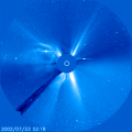
The expanding cloud could reach our planet as early as Wednesday and trigger geomagnetic storms. Sky watchers should be alert for auroras.
http://www.spaceweather.com/
John
 Topic 53 of 92 [Geo]: Earth and Sun Digest
 Response 80 of 85: John Tsatsaragos  (tsatsvol) * Wed, Jul 24, 2002 (18:10) * 10 lines
SOLAR ACTIVITY ALERT:
Sunspot 39 is remarkably active. In recent days it has unleashed two X-class solar flares, caused radio blackouts on Earth, and fueled an ongoing radiation storm. High solar activity will likely continue for the rest of the week at least.
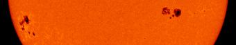
Two big spots appear on the Sun today: sunspot 39 (left) and 36 (right). Both pose a threat for powerful flares. You can see these active regions yourself, but never look directly at the Sun! Use safe solar projection techniques.
http://www.spaceweather.com/
John
 Topic 53 of 92 [Geo]: Earth and Sun Digest
 Response 81 of 85: John Tsatsaragos  (tsatsvol) * Wed, Jul 24, 2002 (18:17) * 18 lines
SAFE SUN WATCHING
Never view the Sun directly with the naked eye or with any unfiltered optical device, such as binoculars or a telescope!
If you're thinking of viewing the Sun, your first concern should always be eye safety. Serious eye damage can result from even a brief glimpse of our star -- Galileo looked at the Sun through a telescope 400 years ago and suffered permanent eye damage. If it happened to Galileo, it can happen to you!
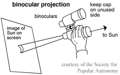
One safe way to observe sunspots or eclipses is to project an image of the Sun through a telescope or binoculars onto a white screen -- paper plates, walls and sidewalks all work nicely. If you're using a telescope, be sure that any small finder telescope is capped. If you're using binoculars, keep the cover on one of the two tubes. Never look through a telescope or binoculars to point them at the Sun -- partial or total blindness will almost surely result.
On the screen you should see a bright circle of light. This is the disc of the Sun. Adjust the distance between the screen and the telescope until the disk is about the size of a small paper plate. The image will probably be blurred; focus your telescope until the circle becomes sharp. Using this method you can see considerable detail in and around sunspot groups.
Pinhole projectors and certain types of solar filters can also afford a safe view of the Sun. Pinhole projectors usually produce a small and unsatisfying image, but they are better than nothing if you don't have a telescope or binoculars.
http://www.spaceweather.com/sunspots/doityourself.html
John
 Topic 53 of 92 [Geo]: Earth and Sun Digest
 Response 82 of 85: John Tsatsaragos  (tsatsvol) * Wed, Jul 24, 2002 (18:24) * 5 lines
It is JULY 24! LAHAINA NOON in Hilo, Hawaii!
Also, in all places of Earth that are on the same parallel.
John
 Topic 53 of 92 [Geo]: Earth and Sun Digest
 Response 83 of 85: Marcia  (MarciaH) * Fri, Jul 26, 2002 (13:01) * 9 lines
Thank you, John! Just like Vampires, we do not cast shadows in Hawaii on July 24th... but that is only at noon. Shortly thereafter, we begin to cast a shadow again just like every other mortal.
This story appeared during my computer absence. I'll post it now because it seems to fit
Shaquille O'Neal's stubby shadow is proof that our planet is tilted--and
summer has arrived in the northern hemisphere.
FULL STORY:
http://science.nasa.gov/headlines/y2002/21jun_shadows.htm?list89800
 Topic 53 of 92 [Geo]: Earth and Sun Digest
 Response 84 of 85: Marcia  (MarciaH) * Fri, Dec 13, 2002 (14:04) * 141 lines
Back to posting Donald Boone's hard work:
Earth and Sun Digest for December 12, 2002
Published weekly by Donald J. Boon, distributed free
Globally focused using the FIVE Rule
...at a Glance (with time ticking)
(All data are "near real time" from USGS and or timely from NOAA/NASA,
full details in tables)
Earthquakes of 5.0 to 5.9 mag thru Wednesday--12; four quakes of 6M or greater: 6.7 NEW IRELAND REGION, P.N.G., 6.3 IRIAN JAYA REGION, INDONESIA, 6.1 SOUTH OF FIJI ISLANDS, 6.0 SOUTHERN EAST PACIFIC RISE
California earthquakes in past week--188, no quakes of 4M or greater
Volcanic ash over 5 mi (8 km)--Ecuador
Sunspot No. high--189 on 9 December
Smallest to largest daily total sunspot area--860 on 5 December to 490 on 7 December
X-Class Solar Flares: none; last M-Class flares (5/day) 6 on 4 October
Planetary Geomagnetic Indices: high of 16 on 7 December; the last set of K-Indices of 4 or more (5 or more/24 hours)--from 26 thru 27 November
Moon for December per Astronomy Magazine
2 perigee, 4 new, 11 first quarter, 13 apogee, 19 full, 26 last quarter, 29 perigee
The apogee of the moon (251,602 miles far) is 13 December.
The second perigee (228,604 miles near) is 29 December.
The Earth and Sun by Date/Day
(Key: Date & day/ X3C or MC=solar flares, GS=Geomagnetic Storm; 6M=quakes; V8=volcanic eruption to 8 km
M02/6M, T03, W04/V8, Th05, F06, Sa07, Su08, M09, T10/6.1M,6.0M, W11/6.3M, Th12/6.7M
The peak of the Geminid Meteor Shower, which has already begun, is the morning of 14 December.
WILL THERE BE A NEW SEISMIC RECORD?
Monthly Summary of Earthquakes of 6 or greater Magnitude
in the World, per USGS/NEIC Preliminary Global Report
YEAR: 93 94 95 96 97 98 99 00 01 02August 2 14 16 6 7 8 9 12 8 12 with two 7M'sSeptember 4 8 8 9 7 4 12 7 10 13 with one 7MOctober 4 12 21 9 6 3 4 8 11 21 with one 7M November 0 7 10 6 7 4 15 15 10 11 with three 7M'sDecember 0 6 13 7 3 2 16 11 7 (6) Yr total 19 110 160 109 76 63 103 109 112 (128)Note: ( ) means incomplete.
Recent Volcanic Eruptions
ETNA Sicily, Italy 37.73�N, 15.00�E; summit elev. 3,315 m
as of 5 December explosive activity, ash emission and lava fountaining vigorous; on 8 December ash emission and lava fountaining changing to violent Strombolian explosions, the following day more ash emission
GUAGUA PICHINCHA north-central Ecuador 0.17�S, 78.60�W; summit elev. 4,784 m
eruption on 7 December at 2120 with ash cloud
KARYMSKY Kamchatka Peninsula, Russia 54.05�N, 159.43�E; summit elev. 1,536 m
during 29 November to 6 December seismicity indicating ash-and-gas explosions ~2.5 km and 5- to 10-minute-long vigorous gas emissions, on 1 December ash plume seen rising to 2 km
KAVACHI Solomon Islands 9.02�S, 157.95�E; summit elev. -20 m (submarine)
during October to November the top broke sea surface to 10 m
KILAUEA Hawaii, USA 19.43�N, 155.29�W; summit elev. 1,222 m
during 4-10 December lava into the sea from two lava deltas
KLIUCHEVSKOI Kamchatka Peninsula, Russia 56.06�N, 160.64�E; summit elev. 4,835 m
on 3 December a gas-and-steam plume to ~6.1 km
PAGO New Britain, Papua New Guinea 5.58�S, 150.52�E; summit elev. 742 m
on 10 December lava slow flow, variable amounts of steam and blue vapor(juvenile volcanic gas)
RABAUL New Britain Island, Papua New Guinea 4.271�S, 152.203�E; summit elev. 688 m
through 11 December slow, convoluted ash plumes to several hundred meters with a small amount of ash in the plumes
REVENTADOR Ecuador 0.078�S, 77.656�W, summit elev. 3,562 m
low-level seismicity through 8 December, white emission columns 3 December and again on 7 December rising to 4.1 km
SHIVELUCH Kamchatka Peninsula, Russia 56.653�N, 161.360�E; summit elev. 3,283 m
seismicity decreasing during 29 November to 6 December, nine ash-and-gas explosions to 5.3 km
SOUFRI�RE HILLS Montserrat, West Indies 16.72�N, 62.18�W; summit elev. 1,052 m
activity during 29 November to 6 December moderate, average of one moderate-sized pyroclastic flow per day
TUNGURAHUA Ecuador 1.47�S, 78.44�W; summit elev. 5,023 m
during 4-9 December emissions of steam, gas, and ash, highest ash cloud was on 4 December to 8.5 km
Ash data is summarized from the weekly GVN/USGS report at
http://www.volcano.si.edu/gvp/reports/usgs/index.cfm
All ash elevations are in km above sea level (a.s.l.).
EARTH
FIVE Index of Global earthquakes of 5.0 magnitude or greater
(More information available at http://quake.wr.usgs.gov/
(6.0 or greater are highlighted in red.) Others are
Japan Region and South Pacific.
DATE-(UTC)-TIME LAT LON Depth Mag. REGIONyear mm dd hh:mm:ss.s deg deg km (READ UP for latest report.) Quake magnitude at last dotReports overlap prior one, except Monthly 6M Report02/12/12 10:19:407.71S156.15E33.05.6SOLOMON ISLANDS02/12/12 08:30:424.71S153.17E33.06.7NEW IRELAND REGION, P.N.G.02/12/12 04:03:1631.71S67.07W126.05.0SAN JUAN PROVINCE, ARGENTINA02/12/11 12:26:380.09N123.32E143.85.4MINAHASSA PENINSULA, SULAWESI02/12/11 10:00:313.65S135.17E10.05.9IRIAN JAYA REGION, INDONESIA02/12/11 03:49:403.75S135.13E10.06.3IRIAN JAYA REGION, INDONESIA02/12/10 21:02:2334.31N141.46E33.05.6OFF E COAST OF HONSHU, JAPAN02/12/10 13:51:2936.16N7.44W29.35.1STRAIT OF GIBRALTAR02/12/10 05:32:5751.60N176.92W33.05.1ANDREANOF ISL, ALEUTIAN IS.02/12/10 04:27:5424.07S179.13E531.06.1SOUTH OF FIJI ISLANDS02/12/10 03:09:3817.77N100.89W82.85.1GUERRERO, MEXICO02/12/10 01:28:3349.98S114.04W10.06.0SOUTHERN EAST PACIFIC RISE02/12/09 09:35:0837.98N20.17E30.05.1A IONIAN SEA02/12/08 08:16:4912.40N144.13
33.05.1A SOUTH OF MARIANA ISLANDS02/12/07 06:22:407.51S127.68E147.55.1A BANDA SEAblu]02/12/05 17:28:0618.93S174.92W122.25.1B TONGA ISLANDS02/12/05 11:14:286.41S153.43E33.05.6A NEW BRITAIN REGION, P.N.G.02/12/05 17:28:0618.93S174.92W122.25.1B TONGA ISLANDS
Note: A degree of latitude is about 69 miles. A degree of longitude falls to 0 mi at the poles.
United States Quakes this past week
with quakes that might be felt:
02/12/12 05:58:3737.53N118.55W11.73.5 CENTRAL CALIFORNIA02/12/11 18:46:1742.48N126.65W10.04.1OFF COAST OF OREGON02/12/11 14:25:2339.36N99.40W5.02.8KANSAS02/12/10 21:47:1532.22N115.80W7.04.0 BAJA CALIFORNIA, MEXICO02/12/10 21:04:0032.23N115.80W7.04.8 BAJA CALIFORNIA, MEXICO02/12/10 05:32:5751.60N176.92W33.05.1ANDREANOF ISL, ALEUTIAN IS.02/12/09 04:31:5444.59N129.44W10.04.2A OFF COAST OF OREGON02/12/09 04:30:4744.29N129.66W10.03.8B OFF COAST OF OREGON02/12/09 04:27:5244.51N129.40W10.04.3B OFF COAST OF OREGON02/12/09 04:21:4844.55N129.18W10.03.7B OFF COAST OF OREGON02/12/09 04:04:4044.60N129.49W10.04.2B OFF COAST OF OREGON02/12/09 03:53:0344.47N129.53W10.03.7B OFF COAST OF OREGON02/12/09 03:46:3144.48N129.47W10.04.4A OFF COAST OF OREGONAlaska Quakes (3-4M) Summary by location (total) CENTRAL ALASKA (4)FOX ISLANDS, ALEUTIAN ISLANDS{1)NORTHERN ALASKA(1)
SUN
Sunspot numbers for the past week 12/4 5 6 7 8 9 10 11 144 153 112 106 150 189 142 171Planetary geomagnetic A Indices for same period 12 9 10 16 12 8 7 6
SPECIAL REPORT
Moon and Volcanic Activity
Volcano Eruptions, By Issue of Weekly Earth and Sun Digest (earliest issue first; * issue closest to a close perigee; FM=full moon, NM=new moon):
January 10*FM, 11, 10, 12, 10*FM
February 14, 9, 11, 13*FM
March 11, 8, 9, 10*FM
April 10, 8, 8, 8
May 12, 7, 8, 11, 9
June 15, 12, 11, 10
July 10, 8, 10, 11
August 14, 10*NM, 11, 12, 13
September 10 (combined issue)*NM, 9, 9
October 9*NM, 7, 13, 13, 13
November 17*NM, 10, 12, 11
December 12*NM, 12
To be in this count the volcano had to be erupting ash or in active lava flow. Not all listed volcanoes met this criterion and were excluded. Late reporting of volcanic activity did not exclude a volcano, as happened with Indonesia, but the report was included the date it was received. Many volcanoes appear in several issues
The FIVE Rule of the Earth and Sun Digest:
FIVE quakes of 5.x magnitude in FIVE Days
can cause a volcano to erupt ash and gas FIVE miles
to the jet streams, where it can circle the globe in FIVE days.
Questions and comments help me serve you better.
Donald J. Boon, editor, donaldboon@comcast.net
 Topic 53 of 92 [Geo]: Earth and Sun Digest
 Response 85 of 85: Marcia  (MarciaH) * Fri, Dec 13, 2002 (14:09) * 3 lines
I have obviously spent too much time in Daniel Boone's land. Donald, I am sorry I misspelled your last name.
Boon Boon Boon Boon Boon...
Geo conference  Main Menu